Wentworth, New Hampshire
Wentworth is a town in Grafton County, New Hampshire, United States. The population was 911 at the 2010 census.[1] The town is home to Plummer's Ledge Natural Area, and part of the White Mountain National Forest is in the northeast. The town has a picturesque common, presided over by a Federal style church and bordered by antique homes.
Wentworth, New Hampshire | |
|---|---|
Town | |
 Wentworth Common | |
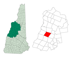 Location in Grafton County, New Hampshire | |
| Coordinates: 43°52′08″N 71°54′36″W | |
| Country | United States |
| State | New Hampshire |
| County | Grafton |
| Incorporated | 1766 |
| Government | |
| • Board of Selectmen | Morgan Currier, Chair Omer C. Ahern Jr. Francis Muzzey |
| Area | |
| • Total | 42.0 sq mi (108.7 km2) |
| • Land | 41.4 sq mi (107.3 km2) |
| • Water | 0.5 sq mi (1.3 km2) 1.21% |
| Elevation | 630 ft (192 m) |
| Population (2010) | |
| • Total | 911 |
| • Density | 22/sq mi (8.4/km2) |
| Time zone | UTC-5 (Eastern) |
| • Summer (DST) | UTC-4 (Eastern) |
| ZIP code | 03282 |
| Area code(s) | 603 |
| FIPS code | 33-80500 |
| GNIS feature ID | 0873752 |
| Website | www |
History
It was granted by Governor Benning Wentworth on November 1, 1766 to John Page and 60 others. Named for the governor himself,[2] Wentworth was settled and incorporated the same year. Many of the settlers arrived from Massachusetts, particularly Salisbury. With a pretty New England common set atop an elevated tongue of land, the village has been noted since the 19th century for its charm; while in "... beauties of landscape, Wentworth has a more than ordinary share." [3]
Farmers cultivated the rich soil on the intervales. The Boston, Concord & Montreal Railroad diagonally crossed the town. With abundant water power from the Baker River, Wentworth developed into a lumber producing town with nine sawmills. But disaster struck on August 6, 1856, when dams on the Upper and Lower Baker ponds in Orford breached during a flood, releasing a wall of water down Pond Brook to the Baker River. It raced three miles (4.8 km) down the steep, rocky channel, then undermined and washed away Wentworth's riverside mills, houses, barns, sheds and roads. It widened the river by nearly 90 feet (27 meters).[3]
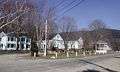 Wentworth Common
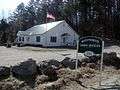 Town offices
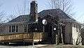 Webster Memorial Library
Geography
According to the United States Census Bureau, the town has a total area of 42.0 square miles (108.8 km2), of which 41.4 square miles (107.2 km2) is land and 0.5 square miles (1.3 km2), or 1.21%, is water.[4] The town is drained by the Baker River and the South Branch Baker River. The highest point in Wentworth is Carr Mountain, at 3,453 feet (1,052 m) above sea level.
The town is crossed north to south by New Hampshire Route 25 and New Hampshire Route 118. New Hampshire Route 25A starts at Routes 25 and 118 at the town center and proceeds west into Orford.
Demographics
| Historical population | |||
|---|---|---|---|
| Census | Pop. | %± | |
| 1790 | 241 | — | |
| 1800 | 488 | 102.5% | |
| 1810 | 645 | 32.2% | |
| 1820 | 807 | 25.1% | |
| 1830 | 924 | 14.5% | |
| 1840 | 1,119 | 21.1% | |
| 1850 | 1,197 | 7.0% | |
| 1860 | 1,055 | −11.9% | |
| 1870 | 971 | −8.0% | |
| 1880 | 939 | −3.3% | |
| 1890 | 698 | −25.7% | |
| 1900 | 617 | −11.6% | |
| 1910 | 595 | −3.6% | |
| 1920 | 507 | −14.8% | |
| 1930 | 459 | −9.5% | |
| 1940 | 491 | 7.0% | |
| 1950 | 413 | −15.9% | |
| 1960 | 300 | −27.4% | |
| 1970 | 376 | 25.3% | |
| 1980 | 527 | 40.2% | |
| 1990 | 630 | 19.5% | |
| 2000 | 798 | 26.7% | |
| 2010 | 911 | 14.2% | |
| Est. 2017 | 947 | [5] | 4.0% |
| U.S. Decennial Census[6] | |||
As of the census[7] of 2000, there were 798 people, 310 households, and 220 families residing in the town. The population density was 19.2 people per square mile (7.4/km²). There were 437 housing units at an average density of 10.5 per square mile (4.1/km²). The racial makeup of the town was 97.62% White, 0.38% African American, 0.25% Asian, 0.13% from other races, and 1.63% from two or more races. Hispanic or Latino of any race were 0.38% of the population.
There were 310 households out of which 31.9% had children under the age of 18 living with them, 60.0% were married couples living together, 7.4% had a female householder with no husband present, and 29.0% were non-families. 21.3% of all households were made up of individuals and 8.4% had someone living alone who was 65 years of age or older. The average household size was 2.57 and the average family size was 3.04.
In the town, the population was spread out with 25.8% under the age of 18, 5.8% from 18 to 24, 29.6% from 25 to 44, 24.7% from 45 to 64, and 14.2% who were 65 years of age or older. The median age was 40 years. For every 100 females, there were 100.4 males. For every 100 females age 18 and over, there were 101.4 males.
The median income for a household in the town was $44,219, and the median income for a family was $47,917. Males had a median income of $31,250 versus $24,500 for females. The per capita income for the town was $18,258. About 6.1% of families and 7.9% of the population were below the poverty line, including 9.7% of those under age 18 and 2.6% of those age 65 or over.
Government
Wentworth uses a town meeting form of government administered by a three-member Board of Selectmen serving staggered three-year terms, with one seat elected each year. In the New Hampshire General Court, Wentworth is in House District 6 and represented by James D. Aguiar (D) and Charles J. Brosseau (R). Wentworth is in Senate District 2 and represented by Jeanie Forrester (R).
Climate
| Climate data for Wentworth, New Hampshire | |||||||||||||
|---|---|---|---|---|---|---|---|---|---|---|---|---|---|
| Month | Jan | Feb | Mar | Apr | May | Jun | Jul | Aug | Sep | Oct | Nov | Dec | Year |
| Average high °F (°C) | 26.8 (−2.9) |
29.6 (−1.3) |
39.6 (4.2) |
52.1 (11.2) |
65.7 (18.7) |
73.6 (23.1) |
78 (26) |
75.4 (24.1) |
67.2 (19.6) |
56.6 (13.7) |
43 (6) |
30.7 (−0.7) |
53.2 (11.8) |
| Average low °F (°C) | 6.9 (−13.9) |
8.7 (−12.9) |
19.8 (−6.8) |
30.8 (−0.7) |
41.5 (5.3) |
50.1 (10.1) |
54.5 (12.5) |
52.8 (11.6) |
45.3 (7.4) |
36.1 (2.3) |
26.9 (−2.8) |
13.2 (−10.4) |
32.2 (0.1) |
| Average precipitation inches (mm) | 2.1 (53) |
2.2 (56) |
2.4 (61) |
2.7 (69) |
3.4 (86) |
3.8 (97) |
3.5 (89) |
4.0 (100) |
3.2 (81) |
3.3 (84) |
3.5 (89) |
2.8 (71) |
36.8 (930) |
| Source: Weatherbase[8] | |||||||||||||
Photo gallery
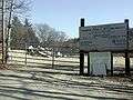 Transfer station
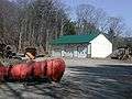 Town garage
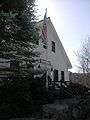 Post Office
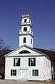 Congregational Church
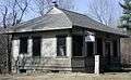 Wentworth Historical Museum
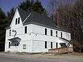 Town Hall
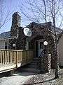 Webster Memorial Library
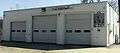 Wentworth Vol. Fire Department
Notable people
- Charles Henry Turner, US congressman
- Thomas Whipple, Jr., US congressman
References
- United States Census Bureau, U.S. Census website, 2010 Census figures. Retrieved March 23, 2011.
- New Hampshire Economic and Labor Market Information Bureau Profile
- Austin J. Coolidge & John B. Mansfield, A History and Description of New England; Boston, Massachusetts
- "Geographic Identifiers: 2010 Demographic Profile Data (G001) - Wentworth town, New Hampshire". United States Census Bureau. Retrieved November 13, 2011.
- "Annual Estimates of the Resident Population: April 1, 2010 to July 1, 2017 (PEPANNRES): Minor Civil Divisions – New Hampshire". Archived from the original on February 13, 2020. Retrieved November 14, 2018.
- "Census of Population and Housing". Census.gov. Retrieved June 4, 2016.
- "U.S. Census website". United States Census Bureau. Retrieved 2008-01-31.
- "Weatherbase". Retrieved 2008-04-17.
External links
- Town of Wentworth official website
- Webster Memorial Library
- Wentworth Elementary School
- Baker River Valley Snowmobile Club
- New Hampshire Economic and Labor Market Information Bureau Profile
Places adjacent to Wentworth, New Hampshire | |
|---|---|
Municipalities and communities of Grafton County, New Hampshire, United States | ||
|---|---|---|
| City | 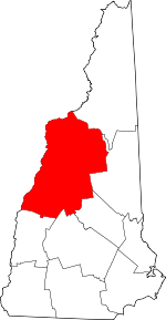 Map of New Hampshire highlighting Grafton County | |
| Towns |
| |
| Township | ||
| CDPs | ||
| Other villages | ||
| Authority control |
|
|---|