Benton, New Hampshire
Benton is a town in Grafton County, New Hampshire, United States. The population was 364 at the 2010 census.[1] Located in the White Mountains, Benton is largely surrounded by the White Mountain National Forest. The town is crossed by the Appalachian Trail.
Benton, New Hampshire | |
|---|---|
Town | |
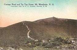 Mount Moosilauke in 1912 | |
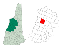 Location in Grafton County, New Hampshire | |
| Coordinates: 44°06′11″N 71°54′06″W | |
| Country | United States |
| State | New Hampshire |
| County | Grafton |
| Incorporated | 1764 |
| Government | |
| • Board of Selectmen | William Darcy, Chair Regina Elliott Carol Vincelette |
| Area | |
| • Total | 48.4 sq mi (125.3 km2) |
| • Land | 48.2 sq mi (124.7 km2) |
| • Water | 0.2 sq mi (0.6 km2) 0.48% |
| Elevation | 1,272 ft (388 m) |
| Population (2010) | |
| • Total | 364 |
| • Density | 7.5/sq mi (2.9/km2) |
| Time zone | UTC-5 (Eastern) |
| • Summer (DST) | UTC-4 (Eastern) |
| ZIP code | 03785 |
| Area code(s) | 603 |
| FIPS code | 33-05060 |
| GNIS feature ID | 0873544 |
| Website | www |
History
The town was granted by Governor Benning Wentworth on January 31, 1764 to Theophilus Fitch and others.[2] It was named Coventry after Coventry, Connecticut, hometown to many of the settlers, who arrived shortly after the beginning of the Revolution.[3] At the suggestion of Governor Isaac Hill, the name was changed on December 4, 1840 to Benton,[4] in honor of Thomas Hart Benton, the Missouri senator who championed American westward expansion.
With a rough and mountainous terrain, the town was not suited for agriculture. But Benton had water power sites and abundant forests. By 1859, when the population was 478, there were five sawmills producing a large quantity of lumber. The Boston, Concord & Montreal Railroad ran through the town, which once included the village of Glencliff.[3]
Atop Mount Moosilauke in 1860 was built The Prospect House, later renamed The Tip Top House, a stone hotel with accommodations for 35 hikers. A carriage road was built to the summit in 1870, so the hotel was enlarged in 1872 to accommodate 50 guests. In 1920, the hotel and land were given to Dartmouth College, but in 1942, The Tip Top House burned.[5]
Geography
According to the United States Census Bureau, the town has a total area of 48.4 square miles (125 km2), of which 48.2 sq mi (125 km2) is land and 0.2 sq mi (0.52 km2) is water, comprising 0.48% of the town. It is drained by the Oliverian Brook and Wild Ammonoosuc River. Benton lies almost fully within the Connecticut River watershed, although a small part of the southeast corner is in the Merrimack River watershed.[6] The highest point in town is the summit of Mount Moosilauke, at 4,802 feet (1,464 m) above sea level.
Benton is crossed by New Hampshire Route 116.
Demographics
| Historical population | |||
|---|---|---|---|
| Census | Pop. | %± | |
| 1840 | 413 | — | |
| 1850 | 478 | 15.7% | |
| 1860 | 459 | −4.0% | |
| 1870 | 375 | −18.3% | |
| 1880 | 378 | 0.8% | |
| 1890 | 244 | −35.4% | |
| 1900 | 209 | −14.3% | |
| 1910 | 219 | 4.8% | |
| 1920 | 177 | −19.2% | |
| 1930 | 255 | 44.1% | |
| 1940 | 262 | 2.7% | |
| 1950 | 247 | −5.7% | |
| 1960 | 172 | −30.4% | |
| 1970 | 194 | 12.8% | |
| 1980 | 333 | 71.6% | |
| 1990 | 330 | −0.9% | |
| 2000 | 314 | −4.8% | |
| 2010 | 364 | 15.9% | |
| Est. 2017 | 370 | [7] | 1.6% |
| U.S. Decennial Census[8] | |||
As of the census[9] of 2000, there were 314 people, 91 households, and 59 families residing in the town. The population density was 6.5 people per square mile (2.5/km2). There were 155 housing units at an average density of 3.2 per square mile (1.2/km2). The racial makeup of the town was 97.45% White, 0.32% Asian, and 2.23% from two or more races.
There were 91 households, out of which 30.8% had children under the age of 18 living with them, 56.0% were married couples living together, 6.6% had a female householder with no husband present, and 34.1% were non-families. 28.6% of all households were made up of individuals, and 11.0% had someone living alone who was 65 years of age or older. The average household size was 2.43 and the average family size was 2.95.
In the town, the population was spread out, with 18.8% under the age of 18, 4.5% from 18 to 24, 22.3% from 25 to 44, 22.0% from 45 to 64, and 32.5% who were 65 years of age or older. The median age was 48 years. For every 100 females, there were 78.4 males. For every 100 females age 18 and over, there were 75.9 males.
The median income for a household in the town was $34,167, and the median income for a family was $40,417. Males had a median income of $28,125 versus $22,188 for females. The per capita income for the town was $13,220. About 3.8% of families and 8.8% of the population were below the poverty line, including none of those under age 18 and 13.0% of those age 65 or over.
See also
References
- United States Census Bureau, American FactFinder, 2010 Census figures. Retrieved March 23, 2011.
- Article in Statistics and Gazetteer of New-Hampshire (1875)
- Austin J. Coolidge & John B. Mansfield, A History and Description of New England; Boston, Massachusetts 1859
- http://www.nh.searchroots.com/documents/grafton/History_Benton_NH.txt
- Frederick Wilkinson Kilbourne, Chronicles of the White Mountains; Houghton Mifflin Company, Boston and New York 1916
- Foster, Debra H.; Batorfalvy, Tatianna N.; Medalie, Laura (1995). Water Use in New Hampshire: An Activities Guide for Teachers. U.S. Department of the Interior and U.S. Geological Survey.
- "Annual Estimates of the Resident Population: April 1, 2010 to July 1, 2017 (PEPANNRES): Minor Civil Divisions – New Hampshire". Archived from the original on February 13, 2020. Retrieved November 14, 2018.
- "Census of Population and Housing". Census.gov. Retrieved June 4, 2016.
- "U.S. Census website". United States Census Bureau. Retrieved 2008-01-31.
External links
- Town of Benton official website
- New Hampshire Economic and Labor Market Information Bureau Profile
- Mount Moosilauke at HiketheWhites.com
- Benton (N.H.) Records,1804-1857 at Dartmouth College Library
Places adjacent to Benton, New Hampshire | |
|---|---|
Municipalities and communities of Grafton County, New Hampshire, United States | ||
|---|---|---|
| City |  Map of New Hampshire highlighting Grafton County | |
| Towns |
| |
| Township | ||
| CDPs | ||
| Other villages | ||
| Authority control |
|
|---|