Uncompahgre National Forest
Uncompahgre National Forest is a U.S. National Forest covering 955,229 acres (1,492.55 sq mi, or 3,865.68 km²) [1] in (in descending order of land area) parts of Montrose, Mesa, San Miguel, Ouray, Gunnison, Hinsdale, San Juan, and Delta Counties in western Colorado. Only its headquarters is in Delta County, in the city of Delta. It borders the San Juan National Forest to the south.
| Uncompahgre National Forest | |
|---|---|
 Wetterhorn Peak in Uncompahgre National Forest | |
 | |
| Location | Colorado, United States |
| Nearest city | Montrose, CO |
| Coordinates | 37.983°N 107.782°W |
| Area | 955,229 acres (3,865.67 km2) |
| Established | June 14, 1905 |
| Governing body | U.S. Forest Service |
| Website | Grand Mesa Uncompahgre and Gunnison National Forests |
Within the national forest boundaries can be found the arid Uncompahgre Plateau and the northern portion of the San Juan Mountains. The forest contains three alpine wilderness areas, Uncompahgre (formerly the Big Blue Wilderness), Mount Sneffels and Lizard Head.
The Uncompahgre National Forest is managed jointly with the Grand Mesa and Gunnison National Forests headquartered in Delta. There are local ranger district offices located in Montrose, Gunnison, and Norwood.
Recreation
The varied climate, sparse population, and abundance of sun make the Uncompahgre National Forest popular with jeepers, atv'ers, sight seers, and hikers. A common recreational activity within the Forest boundaries is scenic driving, thanks in part to the Million Dollar Highway.
There are several dirt roads within the Uncompahgre; some are mining roads left from the 1800s mineral rush, others are occasionally used by the Forest Service. Paved roads include the San Juan Skyway, Alpine Loop, the Unaweep-Tabeguache Scenic and Historic Byway and Owl Creek Pass, which is gravel.
 Colorado with Uncompahgre National Forest in red
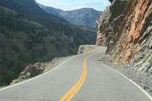 The Million Dollar Highway along the Uncompahgre Gorge, just south of Ouray, Colorado
Wilderness areas
There are three officially designated wilderness areas lying within Uncompahgre National Forest that are part of the National Wilderness Preservation System. One of them lies mostly in a neighboring National Forest, while another one extends onto land that is managed by the Bureau of Land Management (as indicated).
- Lizard Head Wilderness (mostly in San Juan NF)
- Mount Sneffels Wilderness
- Uncompahgre Wilderness (partly on BLM land)
See also
- Grand Mesa Scenic and Historic Byway
References
- Table 6 - NFS Acreage by State, Congressional District and County - United States Forest Service - September 30, 2007
External links
- Grand Mesa, Uncompahgre and Gunnison National Forests (United States Forest Service)
- GORP
- GORP list of campgrounds

| Authority control |
|
|---|