Cherokee National Forest
The Cherokee National Forest is a large National Forest created on June 14, 1920 and managed by the U.S. Forest Service and encompassing some 655,598 acres (2,653.11 km2).
| Cherokee National Forest | |
|---|---|
 South Fork of Citico Creek in the Cherokee National Forest | |
 | |
| Location | Tennessee, United States |
| Nearest city | Johnson City, TN |
| Coordinates | 36°29′N 82°05′W |
| Area | 655,598 acres (2,653.11 km2)[1] |
| Established | June 14, 1920[2] |
| Governing body | U.S. Forest Service |
| Website | Cherokee National Forest |
Location
The Cherokee National Forest headquarters are located in Cleveland, Tennessee.
The Cherokee National Forest mostly lies within eastern Tennessee, along the border with North Carolina, and comprises nearly the entire border area except for sections within the Great Smoky Mountains National Park and the Copper Basin. The Cherokee National Forest has two separate sections: a northern region to the northeast of the Great Smoky Mountains National Park and a southern section to the southwest of the Smokies.[3]
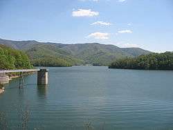
The Cherokee National Forest contains such notable sites as the Ocoee River (site of the 1996 Olympic whitewater events); 150 miles (240 km) of the Appalachian National Scenic Trail; Citico Creek Wilderness; Big Frog Mountain within Big Frog Wilderness, and surrounds both the Tennessee Valley Authority Watauga Reservoir and Wilbur Reservoir.
The forest is located in parts of ten counties in Tennessee and one county in North Carolina. In descending order of forestland area they are Polk, Monroe, Carter, Unicoi, Cocke, Johnson, Greene, Sullivan, Washington and McMinn counties in Tennessee and Ashe County in North Carolina.[4]
Wildlife
The forest is home to mammalian species such as black bear, raccoon, coyote, skunk, opossum, beaver, two species of squirrel, bobcat, chipmunk, river otter, two species of fox, woodchuck, and white-tailed deer.
Birdwatchers commonly view species of juncos, mourning doves, chimney swifts, eastern phoebes, barn swallows, blue jays, indigo buntings, cardinals, towhees, sparrows, chickadees, and warblers. Raptors include turkey vultures, hawks, eagles, and peregrine falcons.
Reptiles include timber rattlesnake, northern copperhead, eastern box turtle, common snapping turtle, and southeastern five-lined skink. Amphibians of frogs, toads, and salamanders are all common residents. Notable species of salamander include Jordan's salamander and hellbender.
Recreation
Recreation opportunities in the Cherokee National Forest are diverse. The forest's fast-flowing rivers support trout fishing. Rainbow trout are stocked in many streams and rivers. Brook trout and brown trout are also present. Bass, bluegill and crappie are found in the forest's lakes, which are also open to wind surfing, water skiing and boating.
Trails criss-cross the forest. In addition to the Appalachian Trail, these include the John Muir Recreation trail, other hiking trails, and some trails designed for equestrian use. Bicycle trails are being developed.
Camping is available in RV campgrounds and tent-only camping areas, and primitive tent camping is allowed throughout much of the forest.
The Unicoi Mountains are a mountain range rising along the border between Tennessee and North Carolina in the southeastern United States. They are part of the Blue Ridge Mountain Province of the Southern Appalachian Mountains. The Unicois are located immediately south of the Great Smoky Mountains and immediately west of the Cheoah Mountains. Most of the range is protected as a national forest, namely the Cherokee National Forest on the Tennessee side and the Nantahala National Forest on the North Carolina side— although some parts have been designated as wilderness areas and are thus more strictly regulated.
Wilderness areas

There are eleven official wilderness areas in Cherokee National Forest, which are all part of the National Wilderness Preservation System. Three of these extend into neighboring National Forests (and also into neighboring states, where the forest changes names):
- Bald River Gorge Wilderness
- Big Frog Wilderness (Cherokee NF in Tennessee and Chattahoochee NF in Georgia)
- Big Laurel Branch Wilderness
- Citico Creek Wilderness
- Cohutta Wilderness (Chattahoochee NF in Georgia and Cherokee NF in Tennessee)
- Gee Creek Wilderness
- Joyce Kilmer-Slickrock Wilderness (Nantahala NF in North Carolina and Cherokee NF in Tennessee)
- Little Frog Mountain Wilderness
- Pond Mountain Wilderness
- Sampson Mountain Wilderness
- Unaka Mountain Wilderness
References
- "Land Areas of the National Forest System" (PDF). U.S. Forest Service. January 2012. Retrieved June 30, 2012.
- "The National Forests of the United States" (PDF). ForestHistory.org. Archived from the original (PDF) on October 28, 2012. Retrieved July 30, 2012.
- "Table 6 - NFS Acreage by State, Congressional District and County". Fs.fed.us. Retrieved 2013-10-26.
- "Table 6 - NFS Acreage by State, Congressional District and County". United States Forest Service. September 30, 2007.
External links

- Official website

| Authority control |
|
|---|