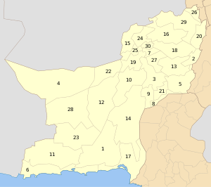
Sujawal District
Sujawal District (also spelled Sajawal; Sindhi: ضلعو سجاول, Urdu: ضلع سجاول) is a district of the Sindh province of Pakistan.[2] It is located at 24°36'23" of North and 68°4'19" of East[3] and is bordered in the northwest by the Indus river which separates it from Thatta District. The district has an area of 7335 km².
Sujawal District ضلعو سجاول | |
|---|---|
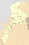
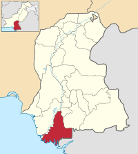 Map of Sindh with Sujawal District highlighted | |
| Country | Pakistan |
| Province | Sindh |
| Capital | Sujawal |
| Established | 12 October 2013 |
| Area | |
| • Total | 7,335 km2 (2,832 sq mi) |
| Population (2017)[1] | |
| • Total | 780,000 |
| • Density | 110/km2 (280/sq mi) |
| Time zone | UTC+5 (PST) |
| Number of Tehsils | 4 |
| Website | borsindh.gov.pk/ |
Administration
Sujawal District is subdivided into five tehsils:
- Jati,
- Kharo Chan,
- Mirpur Bathoro,
- Shah Bandar
- and Sujawal.[4]
History & Geography
The decision to divide Thatta District into two districts by the provincial government was made on 12 October 2013 through a notification issued by Revenue Department of Sindh. The provincial revenue department said…
A new district encompassing Sujawal, Kharochhan (barring 10 dehs), Mirpur Bathoro, Jati and Shah Bundar tehsils (talukas) would be Sindh’s 28th district to be called Sujawal. Its headquarters will be located in Sujawal tehsil (taluka). The new district has been established under Section 6 of the Sindh Land Revenue Act, 1967.[5]
According to the notification the right side of Indus River will comprise old Thatta district and the left side will come under the jurisdiction of newly created Sujawal. The Thatta District (area wise among the largest districts of the province), will have half the size in its new boundaries, comprising Thatta, Mirpur Sakro, Keti Bunder and Ghorabari tehsils (talukas). And some areas of Kharochhan tehsil (taluka) have also been included in new Thatta District. The historical city of Thatta, which was once the capital of Sindh, was carved out from Karachi as a separate city in August 1948. It was the second largest district in Sindh, in terms of area, covering over 17,335 square kilometers before recently separation into two parts. Provincial Revenue Department of Sindh Notification 12 October 2013. There are two Provincial Assembly seats Constituency PS-86 and Constituency PS-87 and one National Assembly seat Constituency NA-238 in newly formed districts Sujawal.[6][7]
Demography and languages
According to the 1998 census, the total population for the talukas of Jati, Kharo Chan, Mirpur Bathoro, Shah Bunder and Sujawal was 530,000. The predominant first language is Sindhi, accounting for 98.6% of the population.[8]
References
- "DISTRICT WISE CENSUS RESULTS CENSUS 2017" (PDF). www.pbscensus.gov.pk. Archived from the original (PDF) on 2017-08-29.
- "Thatta Split to Make Sujawal 28th district of Sindh". Dawn News. Retrieved 25 October 2013.
- "Location of Sujawal - Falling Rain Genomics". Falling Rain Genomics. Retrieved 25 October 2013.
- "Sujawal summary" (PDF). Retrieved 2018-09-04.
- Provincial Revenue Department of Sindh Notification 12 October 2013. Cited in: "New Formation of Districts". Pak Times. Retrieved 25 October 2013.
- Provincial Revenue Department of Sindh, Pakistan's Notification on 12 October 2013
- "New formation of Both Districts (Thatta & Sujawal)". The Pioneer. Retrieved 25 October 2013.
- 1998 District census report of Thatta. Census publication. 54. Islamabad: Population Census Organization, Statistics Division, Government of Pakistan. 1999. table 10.
External links
Provincial capital: Karachi | ||
| Banbhore | 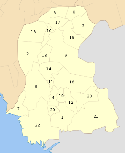 | |
| Hyderabad | ||
| Karachi | ||
| Larkana | ||
| Mirpur Khas |
| |
| Sukkur | ||
| Shaheed Benazir Abad |
| |
| Disputed | ||
List of Districts of Pakistan | ||||||||||||||||||||||||||
|---|---|---|---|---|---|---|---|---|---|---|---|---|---|---|---|---|---|---|---|---|---|---|---|---|---|---|
| ||||||||||||||||||||||||||
| ||||||||||||||||||||||||||
| ||||||||||||||||||||||||||
| ||||||||||||||||||||||||||
| ||||||||||||||||||||||||||
| ||||||||||||||||||||||||||
| ||||||||||||||||||||||||||
| ||||||||||||||||||||||||||
| ||||||||||||||||||||||||||
_Districts.svg.png)