Astore District
Astore (Urdu: ضلع استور) is one of the ten districts of Gilgit-Baltistan, Pakistan. The district contains the Astore Valley (with the town of Astore) and is bounded to the west by Diamer District (from which it was separated in 2004), to the north by Gilgit District, to the east by Skardu District and to the south by Khyber-Pakhtunkhwa and Neelum District of Kashmir. According to the 1998 census of Pakistan the population was 71,666.
Astore District ضلع استور | |
|---|---|
District | |
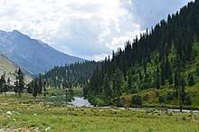
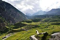 The Rama Valley near Astore | |
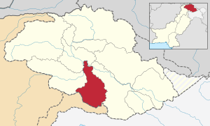 map of Gilgit-Baltistan (in yellow) whereas Astore district location is orange colored . | |
| Country | Pakistan |
| Region | Gilgit-Baltistan |
| Area | |
| • Total | 5,092 km2 (1,966 sq mi) |
| Population (1998) | |
| • Total | 71,666 |
| Time zone | UTC+5 (PST) |
| Number of Tehsils | 2 |
| Website | http://visitgilgitbaltistan.gov.pk/astore/district-astore/ |
The valley
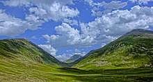
The Astore valley has an area of 5,092 km² and an altitude of 2,600 metres (8,500 ft). The valley has an approximately 250 square kilometres (97 sq mi) of glacier cover.[1] The nearest glacier after entering the valley is Harcho [2] and the most easily accessible glacier is Siachen.[3]
Accessibility
Astore is connected to Gilgit which is well connected by air with Islamabad and by road with Islamabad/Rawalpindi, Skardu and Chitral. It connects it with the Indian held Kashmir, Northwest connects with Azad Kashmir, in the East it connects with the Skardu, in the West it connects to outskirts of Chilas. There are two ways to access to Astore, first is via Deosai 143 kilometres (89 mi) from Skardu city[4], but it is can not be use from November to June due to heavy snowfall and second way, for all seasons, is via Jaglot 128 kilometres (80 mi) from Gilgit city.[5]
History
According to the Imperial Gazetteer of India, around 1600:
Ghāzī Mukhpun, a Persian adventurer, is said to have married a princess of the Skārdu reigning family. The four sons born of this union became Rās of Skārdu, Astor, Rondu, and Kharmang respectively, and from them are descended the families of the present chiefs of those places. The independence of Astor ceased at the Dogra conquest.[6]
Climate
Astore valley has a moderate climate during summer. In winter it can snow up to 2 to 3feet (60-90;cm) in the main valleys and up to 4-5;feet (100;150;cm) in the mountains. In Mirmalik valley it snows up to 6 feet (1.8 m) in February.
Languages
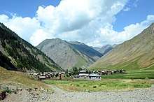
The main language spoken in the valley is Shina. Urdu, which is the National language of Pakistan, is the second most frequently spoken language. There are different dialect of Shina spoken in the region. Since Astore has a history of modest tourist traffic in the summer months, local guides and police in Tarashing or Astore may speak some English.
Education
According to the Alif Ailaan Pakistan District Education Rankings 2015, Astore is ranked 32 out of 148 districts in terms of education. For facilities and infrastructure, the district is ranked 114 out of 148 and the first lady Governor of Pakistan (Gilgit-Baltistan) Dr. Shama Khalid belonged to Astore District.[7]
Transport
There were some negative perceptions in past due to rough mode of transport but nowadays there are paved roads connecting Gilgit and Islamabad through the Karakorum Highway. Landslides and rockfall may be an issue in some areas of the Indus Valley. There is a permanent road through Gilgit as well as seasonal road access via Deosai Plateau to Skardu. Here you can obtain all types of vehicles (Jeeps, taxis, wagons, SUVs) and hire jeeps and SUVs at affordable prices. The most used vehicles are Jeeps and SUVs with a local preference for Pajeros and Landcruisers.
Places of interest
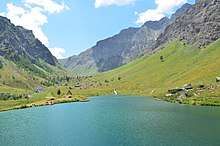
Astore lies about the massive base of Nanga Parbat, the 9th highest peak in the world. To the south of the Nanga Parbat massif lies Rama Valley, which is home to Rama Lake, with basic facilities for visitors. It has a hotel called the PTDC, constructed by the government of Pakistan. Astore valley is a unique area for tourists to visit, surrounded by the high peaks of the far western Himalaya. Nearby the two river junction the village Louse, popular for apples, apricot, cherry and other fruits especially the wild almond oil. Louse a small village with literacy rate of about 95%, the only biggest power house for electricity supply up to 1000 kW to whole district approx since 1987, nearby Louse a peaks include Nanga Parbat, Shaigiri, Rupal Peak, Chongra Peak and Laila Peak (Rupal Valley). Astore Valley ascends from the Indus River Valley near Jaglot, Pakistan..
Deosai plains are the highest plateau in himalayas and are most picturesque with a bowl shaped lake, wild flowers, and a habitat of brown bear. The easiest route from Astore is via, Gorikot, (tarzay sultan abad) Gudai, Chilum and then a track leads to this area with little steep hike. It has been declared a Natural park, a special status to preserve its flora and fauna.
Rupal Valley is one of the prominent tourism spots of Astore Valley. it lies in the east of Nanga Parbat, the killer mountain (8126m). Moreover, a huge amount of water from Nanga Parbat Glacier, named Rupal River passes through Tarishing and meet with Nala Rattu at Rehmanpur. Then it flows towards east and meet with Nala Gudai at the starting point of Gorikot and become a major river of Astore Valley. This river falls in Indus River at Bunji, one of Astore Valley's village.
Allah Wali jeel also called "Allah named Lack" is one of another ancient tourism spot of Astore Valley. It is at the end of Perishing valley in Gotomsar town, 45 minute drive away from the Astore (HQ). The name Allah written by river is famous because the river passes only through the vast aisle in the huge greenfield, This aisle is in zigzag manner and name of Allah becomes obvious if it is looked from some altitude. The greenfield is nearly 5,000 m2 bounded by the high altitude mountains. There is Rest House build by the government to provide night stay accommodation and kitchen facilities for both national and international tourists. The broad greenfield is attractive for sports activities. In each year an official sports[football, cricket, volleyball and swimming] tournament event is held in July and august.
References
- Sher Muhammad, Lide Tian, Asif Khan, Early twenty-first century glacier mass losses in the Indus Basin constrained by density assumptions, Journal of Hydrology, Volume 574, 2019, Pages 467-475
- MUHAMMAD, S., TIAN, L., & NÜSSER, M. (2019). No significant mass loss in the glaciers of Astore Basin (North-Western Himalaya), between 1999 and 2016. Journal of Glaciology, 65(250), 270-278. doi:10.1017/jog.2019.5
- Muhammad, S. and Tian, L. (2016) ‘Changes in the ablation zones of glaciers in the western Himalaya and the Karakoram between 1972 and 2015’, Remote Sensing of Environment. Elsevier Inc., 187, pp. 505–512. doi: 10.1016/j.rse.2016.10.034.
- "Distance from Skardu via Deosai Plains". Google Maps. Retrieved 4 August 2019.
- "Distance from Gilgit via Jaglot". Google Maps. Retrieved 4 August 2019.
- Gilgit - Imperial Gazetteer of India, v. 12, p. 239 According to the Imperial Gazetteer, which was compiled in the first decade of the twentieth century, the marriage took place over three hundred years previously.
- "Individual district profile link, 2015". Alif Ailaan. Archived from the original on 2016-03-26. Retrieved 2015-05-07.
| Wikimedia Commons has media related to Astore District. |
| Passes | |
|---|---|
| Valleys |
|
| Cities and towns |
|
| Rivers, glaciers and lakes | |
| Architecture | |
| See also | |