Qambar Shahdadkot District
Qambar Shahdadkot District (Sindhi: ضلعو قمبر شهداد ڪوٽ ) is a district of Sindh, Pakistan. District Qambar Shahdadkot, with headquarters at Qambar, was established on 13 December 2004. Taluka Qambar and Shahdadkot were part of Larkana district since long before they were combined and made one district for administrative purposes. At first it was named only Qambar but because of dissent from the people of Shahdadkot city, the name Shahdadkot was added. Today, however, the locals of Shahdadkot demand a separate district comprising Shahdadkot, Qubo Saeed Khan and Sijawal Junejo as they face difficulties in governmental work because they must go a long distance to Qambar to get the work done because most government offices are there. The district was created in the tenure of Chief Minister Arbab Ghulam Rahim, who is accused of creating this district for political gains and to weaken the stronghold of Pakistan People's Party in the area because Shahdadkot has been the electoral constituency for Shaheed Benazir Bhutto. The creation of the district benefited Chandios, who are the landlords of Qambar Shahdadkot. In 2005, Nawab Shabbir Khan Chandio became the first elected nazim of the newly created district.
Shahdadkot District ضلعو قمبر شهداد ڪوٽ | |
|---|---|
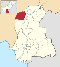 Map of Sindh with Qambar District highlighted | |
| Country | Pakistan |
| Province | Sindh |
| District created | 2004 |
| Headquarters | Qambar |
| Population (2017)[1] | |
| • Total | 1,341,042 |
| Time zone | UTC+5 (PST) |
| Website | www |
History
The district was split from Larkana District in December 2005. There was some controversy over the name of the district, with Qambar being favoured initially, but after protests from residents of Shahdadkot, it was renamed to Qambar-Shahdadkot District. The headquarters of the district is Qambar city.
Administrative divisions
The total area of District Qambar Shahdadkot is 1453383 acres. The district is divided into seven talukas: Qambar, Miro Khan, Shahdadkot, Warah, Sija Wal Junejo, Nasirabad and Qubo Saeed Khan. Taluka Qambar has the largest area, 522,462 acres. District Council Qambar Shahdadkot has 52 union councils, two municipal committees and seven town committees.
- Qambar
- Shahdadkot
- Warah
- Miro Khan
- Nasirabad
- Qubo Saeed Khan
- Sijawal Junejo
The district government comprises seven groups of offices i.e. health, education, works and services, finance and planning, community development, revenue and agriculture besides district administration comprising a District Nazim (mayor), Naib Nazim (deputy mayor) and District Coordination Officer.
Education
According to a survey conducted by Sindh Education Management Information System in 2010-11, there are 377 schools for boys, 306 schools for girls, and 997 co-ed schools. The boys' schools enroll 7538 students, and the girls' schools enroll 33,061. The total number of all enrolled students is 195,774. The total number of teachers in the district is 4239, of whom, 3411 are male and 828 are female. The student to teacher ratio is 46. The number of functional schools in urban areas is 91, and in rural areas it is 1439. The total number of closed schools in the district is 150. The total number of schools in Qambar Shahdadkot is 1680.
Geography
Qambar Shahdakot shares its borders with three districts of Balochistan on the west, Khuzdar, Jaffarabad and Jhal Magsi. Its southern borders are connected with district Dadu. District Larkana is on the east and district Jacobabad is on the north.
The district has a variety of features with its vast plains, agriculture land, the mighty mountain range of Kirthar and a number of wetlands including Hamal, Drigh and Langh lakes. The Khirthar extends southward for almost 300 km from the Mula River in east-central Balochistan to Cape Muari (Monze) west of Karachi on the Arabian Sea. Khirthar in Sindhi means 'milk-cream', which is contrary to the environment of the place. It is a range of limestone hills and mountains which is referred to as Hallar by the old writers, but it is commonly known as Kirthar today.
The Khirthar range also has a national park, which is the second largest wildlife park in the area. It is located between Karachi and Balochistan. This area is covered with limestone hills which rise from 4000 to nearly 8000 feet and are surrounded by the fossilized remnants of different times of history.
The inhabitants of the region are chiefly Balochi and Sindhi who belong to Brahui tribe and they survive by flock graze. Chhuttas of Balochistan, Chandios and Gainchos of Sindh also live in this area.
Rare species of animals are found in Khirthar National Park, including the Sindh wild goat, Indian fox, Egyptian vulture, Indian pangolin, desert wolf, Chinkara gazelle, honey badger, jackal, Asiatic leopard, Bonnelli's eagle, striped hyena, jungle cat, and a number of reptile and bird species.
Demographics
The following are the demographic indicators of the district. The population of the district was 1,487,770 as of 2015.[2]
The predominant first language is Sindhi, which in 1998 accounted for 98% of the total population in the talukas of Shahdadkot, Warah, Kamber Ali khan, Sijawal Junejo and Miro Khan.[3]
Industry
The Shahdadkot Textile Mills was situated in the north of Shahdadkot City. It employed around 4500 workers in the district which was previously part of Larkana. The mill was established in 1974 under the orders of Zulfikar Ali Bhutto, then prime minister of Pakistan. Iran had assisted Pakistan for the installation of the mill in Shahdadkot. The mill was started in 1978 and became the source of livelihood of many people living in all four provinces. The cloth from here was sent to Punjab for sale. The mill produced export quality cloth.
Due to political problems after Zulfikar Ali Bhutto's time and financial crisis to the mill, it could not pay salaries to its 4000 workers and this led to the downfall of the mill during Zia's regime. When Benazir Bhutto returned to the government in 1990, the mill again started to produce fine polyester productions of various designs. Abdul Fatah Bhatti, funded by Nisar Memon, a contractor from Karachi, was given complete authorization to operate in the mills. He even expelled the few remaining workers from the Mills and put up a notice of shutting down of the mills on July 8, 2007. Because of political and economic crisis, the mills and the industry in the district suffered and its infrastructure was sold for a petty amount. Now it wears a deserted look.
The present small industries are as follows: electronic goods, agricultural tools, construction material and food processing through bakeries and shops. The cottage industry of embroidery caps particularly in Shahdadkot Taluka has a good market in the district as well as outside the district.
References
| Wikimedia Commons has media related to Qambar Shahdadkot District. |
- "DISTRICT WISE CENSUS RESULTS CENSUS 2017" (PDF). www.pbscensus.gov.pk. Archived from the original (PDF) on 2017-08-29.
- "Sindh population surges by 81.5 pc, households by 83.9 pc". Thenews.com.pk. 2 April 2012. Retrieved 2013-04-21.
- PCO 1999, pp. 123–25.
Bibliography
- 1998 District census report of Larkana. Census publication. 30. Islamabad: Population Census Organization, Statistics Division, Government of Pakistan. 1999.
Provincial capital: Karachi | ||
| Banbhore | 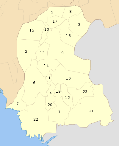 | |
| Hyderabad | ||
| Karachi | ||
| Larkana | ||
| Mirpur Khas |
| |
| Sukkur | ||
| Shaheed Benazir Abad |
| |
| Disputed | ||