Toba Tek Singh District
Toba Tek Singh District (Urdu: ضلع ٹوبہ ٹیک سنگھ) is a district of Faisalabad Division in the Punjab province of Pakistan. It is located between 30°33' to 31°2' Degree north latitudes and 72°08' to 72°48' Degree longitudes.[3] It became a separate district in 1982.[1]:1
Toba Tek Singh District | |
|---|---|
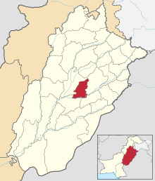 Location of TTS in Punjab. | |
| Country | Pakistan |
| Province | Punjab |
| Headquarters | Toba Tek Singh |
| Area [1]:1 | |
| • District | 4,364 km2 (1,685 sq mi) |
| Population | |
| • District | 2,190,015 |
| • Density | 500/km2 (1,300/sq mi) |
| • Urban | 441,930 |
| • Rural | 1,748,085 |
| Time zone | UTC+5 (PST) |
| Number of Tehsils | 4 |
Etymology
The city and district is named after a Sikh religious figure Tek Singh. Legend has it that Mr. Singh a kind-hearted man served water and provided shelter to the worn out and thirsty travelers passing by a small pond ("TOBA" in Punjabi) which eventually was called Toba Tek Singh, and the surrounding settlement acquired the same name.[3] There is also a park here named after the Sardar Tek Singh. There was a pond of water of "Sikh"
British Raj
Toba Tek Singh was developed by the British toward the end of the 19th Century when a canal system was built. People from all over the Punjab (currently Indian and Pakistani Punjab) moved there as farmlands were allotted to them. Most of the people who migrated there belonged to Lahore, Jalandhar, Hoshiarpur districts. The Imperial Gazetteer of India described the tehsil of Toba Tek Singh as follows:
Tehsil of the new Faisalabad District, Punjab, lying between 30°50' and 31°23' N. and 72° 20' and 72°54' E., with an area of 865 square miles (2,240 km2). The population in 1906 was 148,984. It contains 342 villages, including Toba Tek Singh (population, 1,874), the headquarters, and Gojra (2,589), an important grain market on the Wazirabad-Khanewal branch of the North-Western Railway. The land revenue and cesses in 1905-6 amounted to 470,000. The tehsil consists of a level plain, wholly irrigated by the Chenab Canal. The soil, which is very fertile in the east of the tehsil, becomes sandy towards the west. The boundaries of the tehsil were somewhat modified at the time of the formation of the new District of Faisalabad"[4] The predominantly Muslim population supported Muslim League and Pakistan Movement. After the independence of Pakistan in 1947, the minority Hindus and Sikhs migrated to India while the Muslim refugees from India settled in the Toba Tek Singh District.
After independence
During the 1970s, when many Pakistani cities were renamed to change names given after British Rulers to their original or native names or more acceptable names to local population like Montgomery was renamed to its old original name Sahiwal, Toba Tek Singh remained one of the very few cities to maintain its original name mainly because of reputation of Tek Singh. In 1982 Toba Tek Singh, formerly a subdivision, was separated from Faisalabad District and became a separate district.[3]
1970 Historical Kissan Conference, 200,000 Kissans (peasants) and progressive people from whole country gathered in Toba Tek Singh. The conference left a great impact on political history of Pakistan and led to Land reforms taken place in Bhutto Era.
Demography
Toba Tek Singh is located in central Punjab and occupies 3252 square kilometers and is made up of large areas of lowlands that flood frequently during the rainy season; the floods originate from the Ravi River that runs along the southern and southeastern borders. During the British Raj, Toba Tek Singh had a small Sikh population, much of which migrated to India after the partition, while many Muslim refugees from modern-day India settled in the Toba Tek Singh District.
According to the 1998 census of Pakistan the population was 905,580 of this, 720,601 were Muslim and 184,979 were non-Muslim, mainly Christian.[5] According to the 2008 estimate the population had risen to 1.39 million.[6]
According to the 1998 census, Punjabi was the predominant first language,[7] accounting for 98.9% of the district's population.[1]:19
Toba Tek Singh District is ranked fifth highest Human Development Index among 94 districts in Pakistan. [8]
Education
Toba Tek Singh has a high literacy rate counted at 25th position from all over Pakistan and 15th in Punjab, maintaining an Education score of 70.12 as published in District Education Ranking report by Alif Ailaan [9]
Administration
The district of Toba Tek Singh is administratively subdivided into four tehsils and 82 Union Council:[10]
| Name of Tehsil | No of Unions |
|---|---|
| Gojra | 24 |
| Kamalia | 13 |
| Toba Tek Singh | 30 |
| Pir Mahal | 15 |
| Total | 82 |
The district is represented in the National Assembly by three elected MNAs who represent the following constituencies:[11][12]
| Constituency | MNA | Party |
|---|---|---|
| NA-111 | Chaudhry Khalid Javaid Warraich | Pakistan Muslim League (N) |
| NA-112 | Muhammad Junaid Anwaar Chaudhry | Pakistan Muslim League (N) |
| NA-113 | Raiz Fatyna | Pakistan Tehrik Insaf) |
The district is represented in the provincial assembly by seven elected MPAs who represent the following constituencies:
| Constituency | MPA | Party |
|---|---|---|
| PP-84 | Ch. Bilal Asghar Warraich | Pakistan Muslim League (Q) |
| PP-85 | Abdul Qadeer Alvi | Pakistan Muslim League (N) |
| PP-86 | Saeed Ahmed Saeedi | Pakistan tehrek Insaf) |
| PP-87 | Lieutenant Colonel (R) Sardar Muhammad Ayub Khan Gadhi | Pakistan Muslim League (N) |
| PP-88 | Begum Nazia Raheel | Pakistan Muslim League (N) |
| PP-89 | Makhdoom Syed Ali Baba | Pakistan Muslim League (N) |
Until the year 2000, when the Divisions of Pakistan were abolished, Toba Tek Singh and Jhang districts were part of Faisalabad Division (this included Faisalabad District.
Major towns in Toba Tek Singh District are:
- Pir Mahal
- Gojra
- Kamalia
- Rajana
- Sandhilianwali
- Mongi Bangla
- Nawan Lahore
References
- 1998 District Census report of Toba Tek Singh. Census publication. 85. Islamabad: Population Census Organization, Statistics Division, Government of Pakistan. 2000.
- "DISTRICT AND TEHSIL LEVEL POPULATION SUMMARY WITH REGION BREAKUP" (PDF). Pakistan Bureau of Statistics. 2017. Retrieved 14 April 2018.
- Official Government website of Toba Tek Singh Archived 2008-03-24 at the Wayback Machine
- Toba Tek Singh – Imperial Gazetteer of India, v. 23, p. 406. Dsal.uchicago.edu. Retrieved on 2011-10-06.
- District Stats – District Government of Toba Tek Singh
- District Profile: Central Punjab- Toba Tek Singh
- The census report has "mother tongue", defined as the language of communication between parents and children.
- List of districts of Pakistan by Human Development Index
- "District Education Ranking" (PDF).
- Tehsils & Unions in the District of Toba Tek Singh – Government of Pakistan. Nrb.gov.pk. Retrieved on 2011-10-06.
- Legislators from Toba Tek Singh – Website of the Provincial Assembly of Punjab
- Election Results 2008 Archived 2011-07-26 at the Wayback Machine. .ecp.gov.pk. Retrieved on 2011-10-06.
External links
- Toba Tek Singh profile on Punjab's government website
Neighbourhoods of Toba Tek Singh | ||
|---|---|---|
Administrations: Toba Tek Singh District | ||
| Tehsils |
|  |
| Cities |
| |
| Towns and councils | ||
| Villages | ||
Website: Toba Tek Singh District at NRB | ||
Provincial capital: Lahore | ||
| Bahawalpur | .png) | |
| Dera Ghazi Khan | ||
| Faisalabad | ||
| Gujranwala | ||
| Lahore | ||
| Multan | ||
| Rawalpindi | ||
| Sargodha | ||
| Sahiwal | ||
| Sheikhupura | ||
See also: Districts of Punjab, India | ||