Battagram District
Battagram District (Pashto: بټګرام ولسوالۍ, Urdu: ضِلع بٹگرام) is a district in Hazara Division of Khyber Pakhtunkhwa province in Pakistan.[2][3][4] The headquarter is Battagram town, which is about 75-km from Mansehra.[2]
Battagram District ضلع بټګرام | |
|---|---|
| ضلع بٹگرام | |
 Location of Battagram District (highlighted in yellow) | |
| Coordinates: 34.41°N 73.1°E | |
| Country | Pakistan |
| Province | Khyber Pakhtunkhwa |
| Capital | Battagram |
| Established | July 1993 |
| Government | |
| • MNA | Muhammad Nawaz Khan Allai (2018-Present) |
| • MPA | Taj Muhammad khan (Trand) (2018-Present) |
| • MPA | Zubair khan (2018-Present) |
| Area | |
| • Total | 1,301 km2 (502 sq mi) |
| Elevation | 1,038 m (3,406 ft) |
| Population (2017)[1] | |
| • Total | 476,612 |
| • Density | 370/km2 (950/sq mi) |
| Time zone | UTC5 (PST) |
| Zip/Postal Code | 21040 |
| Area code(s) | 0997 |
| Number of Tehsils | 2 |
Overview and history
The district of Battagram is located at the latitude of 34.41 and longitude 73.1. It is surrounded by Kohistan District to the north, Mansehra District to the east, Kala Dhaka (now Torghar District) to the south and Shangla District to the west.[2]
It has a total land area of 1301 square kilometres. Battagram obtained the status of district in July 1993 when it was upgraded from a Tehsil and separated from Mansehra District.[5]
Demographics
The population of Battagram district, according to the 2017 census, is 476,612.[6] The population of the district over the years is shown in the table below.[7]
| Census Year | Population | Rural Area | Urban Area |
|---|---|---|---|
| 1961 | 94,357 | 94,357 | None |
| 1972 | 174,009 | 174,009 | None |
| 1981 | 339,119 | 339,119 | None |
| 1998 | 307,278 | 307,278 | None |
| 2017 | 476,612 | N/A | N/A |
The population counted in the 1998 census was 307,000.[8] The predominant language is Pashto, which according to the census of 1981 was the language of communication within 84% of households, whereas Hindko accounted for 3.6%.[9]
Administration
The district has geographical borders with the districts of Kohistan to the north, Mansehra to the east and southeast, Torghar to the south and Shangla to the west. The district consists of two sub-divisions or Tehsils, containing 20 in total. Union Councils:[10]
| Tehsil | No. of Unions | Name of Unions |
|---|---|---|
| Allai Tehsil | 8 | Banna, Bateela, Batkul‚ Biari, Jambera, Pashto, Rashang and Sakargah |
| Batagram Tehsil | 12 | Ajmera, Banian, Battagram, Batamori, Gijbori, Kuza Banda, Paimal Sharif, Peshora, Rajdhari, Shumlai, Thakot and Trand |
The district is represented in the provincial assembly by two MPAs from its constituencies PF-59 (Battagram-1) and PF-60 (Battagram-2).[11]
2005 earthquake
Battagram was one of the areas affected by the Pakistan earthquake of October 8, 2005 when more than 4,500 people were killed and approximately 35,000 were injured.[2][12] Many residents of the area were rendered homeless and without shelter. Since October 8, 2005, the NGOs and the governmental organization Earthquake Reconstruction and Rehabilitation Authority have been engaged in reconstruction work but as of 2009, the reconstruction work is not completed. In some cases residents have rebuilt houses themselves.[13]
References
- "DISTRICT WISE CENSUS RESULTS CENSUS 2017" (PDF). www.pbscensus.gov.pk. Archived from the original (PDF) on 2017-08-29. Retrieved 2017-09-01.
- "District Profile BATTAGRAM (PDF)" (PDF). www.erra.pk. Retrieved 2017-12-02.
- Correspondent, A (2017-09-29). "Hazara varsity campus sought in Battagram". DAWN.COM. Retrieved 2017-12-02.
- "Abaseen division to be approved after population census: Hoti". The Nation. Retrieved 2017-12-02.
- PCO 1998, p. 18.
- "Pakistan Tehsil Wise Census 2017 [PDF]" (PDF). www.pbscensus.gov.pk. Archived from the original (PDF) on 2017-11-07. Retrieved 2017-11-29.
- "AREA & POPULATION OF ADMINISTRATIVE UNITS BY RURAL/URBAN: 1951-1998 CENSUSES (PDF)" (PDF). www.pbs.gov.pk. Retrieved 2017-12-02.
- PCO 1998, p. 73.
- PCO 1981, p. 73.
- Tehsils & Unions in the District of Battagram – Government of Pakistan, NRB, archived from the original on 9 February 2012, retrieved 19 March 2012
- Constituencies and MPAs – Website of the Provincial Assembly of the NWFP, PANWFP, archived from the original on 28 April 2008, retrieved 19 March 2012
- "Aftermath: What if a killer earthquake were to strike Karachi - The Express Tribune". The Express Tribune. 2012-07-29. Retrieved 2017-12-02.
- "NRC PAKISTAN EARTHQUAKE SITUATION REPORT – WEEK ENDING 5TH FEB 2006" (PDF). Archived from the original (PDF) on 2011-06-08. Retrieved 2017-12-02.
Bibliography
- 1981 District Census report of Mansehra. District Census Report. 23. Islamabad: Population Census Organization, Statistics Division, Government of Pakistan. 1983.
- 1998 District Census report of Batagram. Census publication. 18. Islamabad: Population Census Organization, Statistics Division, Government of Pakistan. 1999.
| Wikimedia Commons has media related to Battagram District. |
Provincial capital: Peshawar | ||
| Divisions | Districts | 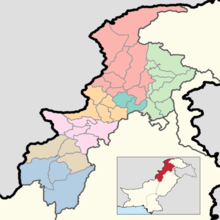 |
| Bannu | ||
| Dera Ismail Khan | ||
| Hazara | ||
| Kohat | ||
| Malakand | ||
| Mardan | ||
| Peshawar | ||
Administrative divisions of Battagram District | ||
|---|---|---|
| Capital | ||
| Tehsils | ||
| Union councils | ||
| Village Councils | ||