Swat District
Swat District (Pashto: سوات ولسوالۍ, pronounced [ˈswaːt̪]; Urdu: ضِلع سوات)[4] is a district in Malakand Division of Khyber Pakhtunkhwa province in Pakistan. Swat is renowned for its outstanding natural beauty. Centred upon the upper portions of the Swat River, Swat was a major centre of early Buddhist thought as part of the Gandhara kingdom, and today is littered with ruins from that era. Swat was home to the last isolated pockets of Gandharan Buddhism, which lasted until the 10th century, well after most of the area had converted to Islam.[5] Until 1969, Swat was part of the Yusafzai State of Swat, a self-governing princely state. The region was seized by the Pakistani Taliban in late 2007,[6] and its tourist industry decimated until Pakistani control over Swat was re-established in mid 2009.[7]
Swat سوات | |
|---|---|
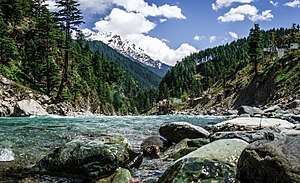 The Swat River flows through the Swat District | |
| Nickname(s): Switzerland of the East[1] | |

| |
| Coordinates: 35°12′N 72°29′E | |
| Country | |
| Province | |
| Capital | Saidu Sharif |
| Largest city | Mingora |
| Area | |
| • District | 5,337 km2 (2,061 sq mi) |
| Population | |
| • District | 2,309,570 |
| • Density | 430/km2 (1,100/sq mi) |
| • Urban | 695,900 |
| • Rural | 1,613,670 |
| Time zone | UTC+5 (PKT) |
| Area code(s) | Area code 0946 |
| Languages (1981) | 90.28% Pashto 8.67% Kohistani[3] |
Swat's capital is Saidu Sharif, though the largest city, and main commercial centre, is the nearby city of Mingora.[8] With a population of 2,309,570 according to the 2017 census, Swat is the 15th-largest district of Khyber Pakhtunkhwa. The region is inhabited largely by Yousafzai Pashtuns, who arrived in the valley from south of Kabul valley in 16 CE, except in the valley's uppermost reaches, where the Kohistani people dominate.[5]
Swat's average elevation is 980 m (3,220 ft),[5] resulting in a considerably cooler and wetter climate compared to most of Pakistan. With lush forests, verdant alpine meadows, and snow-capped mountains, Swat is one of the country's most popular tourist destinations.[9][10] Swat has many places for visiting like Kalam,Malamjabba,Mahodand. Swat has also many historical places like Butkara , Shingardar stupa ,Saidu stupa.
Etymology
The name "Swat" is of Sanskrit origin. One theory derives it from "Suvastu", the ancient name of the Swat River (Suastus in Greek literature);[11] "Suvastu" literally means "clear azure water", and is attested in the earliest Sanskrit text, the Rigveda.[12] Another theory derives the word Swat from the Sanskrit word "Shveta" (white), also used to describe the clear water of the Swat River.[11]
History
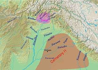
The earliest recorded history, mainly orally transmitted, was the settlement and societies of the Indo-Aryan peoples. According to E.R. Leach: "Swat lies on the edge of the Indian world".[13] These Indo-Aryan tribes of the Rig Veda, followed created the earliest settlement and cultures in Swat, some of these Indo-Aryan settlements, launched from Swat, gave rise or influenced the early cultures of ancient India, such as the Cemetery H culture, Copper Hoard culture and Painted Grey Ware culture toward northwest India. Later movements of the Indo-Aryan tribes saw the emergence of Nuristani or Dardic populations.[14]
In 327 BC, Alexander the Great fought his way to Odigram and Barikot and stormed their battlements. In Greek accounts these towns have been identified as Ora and Bazira. This area was then ruled over by the Indo-Greek Kingdom for centuries. Around the 2nd century BC, the area was occupied by Buddhists, who were attracted by the peace and serenity of the land. There are many remains that testify to their skills as sculptors and architects. Later some Swati entered the area along with Sultans from Kunar and their tribe was styled as Swatis. The originator of the present family of Swat was the Muslim saint Akhund Abdul Gaffur, more commonly known as Saidu Baba. He was a pious man and the people respected him so greatly that they called him Akhund Sahib.[15][16]
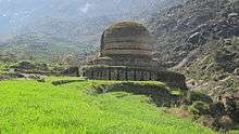
Buddhist heritage

Historically known as Uddiyana, Tantric Buddhism flourished under King Indrabhuti. However, there is an old and well-known scholarly dispute as to whether Uddiyana was in the Swat Valley, Orissa, or somewhere else. Padmasambhava (flourished eighth century AD), also called Guru Rimpoche, Tibetan Slob-upon (teacher), or Padma 'Byung-gas (lotus born), semi-legendary Indian Buddhist mystic who introduced Tantric Buddhism to Tibet was, according to tradition, native from Uddiyana.[17] He is revered as the second Buddha in Tibet. Padmasambhava is said to be the son of Indrabhuti, king of Swat in the early eighth century AD and one of the original Siddhas. Indrabhuti's sister, Lakshminkaradevi, is also said being an accomplished Siddha of the 9th century AD.[18]
Ancient Gandhara, the valley of Pekhawar, with the adjacent hilly regions of Swat, Buner, Dir, and Bajaur, was one of the earliest centers of Buddhist religion and culture following the reign of the Mauryan emperor Ashoka, in the third century BC. The name Gandhara first occurs in the Rigveda which is usually identified with the region[19]
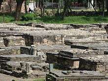
The Gandhara school is credited with the first representations of the Buddha in human form, rather symbolically as the wheel of the law, the tree, etc.
Hindu Shahi
Swat was ruled by the Hindu Shahi dynasty, who built an extensive array of temples and other architectural buildings, now in ruins. Sanskrit may have been the lingua franca of the locals.[20]
Hindu Shahi rulers built fortresses to guard and tax the commerce through this area. Their ruins can be seen in the hills of Swat: at Malakand pass at Swat's southern entrance.[21]
Advent of Islam by Mahmud of Ghazni
At the end of the Mauryan period (324–185 BC), Buddhism spread in the whole Swat Valley, which became a very famous center of Buddhist religion.
After a Buddhist phase the Hindu religion reasserted itself, so that at the time of the Muslim conquest (1000 AD) the population was solidly Hindu.[16]:19
In 1023, Mahmud of Ghazni attacked Swat and crushed the last Buddhist King, Raja Gira in battle. y.[22]
Taliban destruction of Buddhist relics
Swat Valley, located in the Khyber Pakhtunkhwa Province, has many Buddhist carvings, statues, and stupas. The town of Jehanabad contains a Seated Buddha statue.[23] Kushan-era Buddhist stupas and statues in Swat Valley were demolished by the Taliban, and after two attempts by the Taliban,[24] the Jehanabad Buddha's face was dynamited.[25][26][27] Only the Bamiyan Buddhas in Afghanistan, which the Taliban also demolished, were larger than the Buddha statue in Swat.[28] The government did nothing to safeguard the statue after the initial attempt at destroying the Buddha, which did not cause permanent harm; when the second attack took place on the statue, the feet, shoulders, and face were demolished.[29] Islamists (particularly the Taliban) and looters destroyed many of Pakistan's Buddhist artifacts, which dated to the Buddhist Gandhara civilization.[30] The Taliban deliberately targeted Gandhara Buddhist relics for destruction.[31] Gandhara artifacts were thereafter plundered by thieves and smugglers.[32] In 2009, the Archbishop of the Roman Catholic Diocsece of Lahore, Lawrence John Saldanha, wrote a letter to Pakistan's government denouncing the Taliban activities in Swat Valley, including their destruction of Buddha statues and their attacks on Christians, Sikhs, and Hindus.[33] A group of Italians helped repair the Buddha.[34]
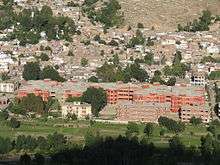
Geography
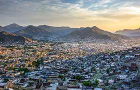
.jpg)
Swat is surrounded by Chitral, Upper Dir and Lower Dir in the West, Gilgit-Baltistan in North Kohistan, Buner and Shangla in the East and South East. The southern tehsil of Buner was granted the status of a separate district in 1991.[35] Swat Valley is located in northern Khyber Pakhtunkhwa and enclosed by sky-high mountains.
Physical Features: Swat can be divided into two physical regions:
- Mountainous Ranges.
- Plains.
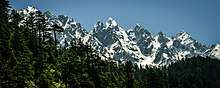
Mountainous ranges
.jpg)
As mentioned above, Swat lies in the lap of mountainous ranges, which are the offshoots of Hindukush, so the larger part of Swat is covered with high mountains and hills, the crests of which are hidden by everlasting snow. Though these gigantic ranges run irregularly: some to the west while the others to the east, the general direction is North-South.
Plains
The length of the valley from Landakay to Gabral is 91 miles. Two narrow strips of plains run along the banks of Swat River from Landakay to Madyan. Beyond Madyan in Kohistan-e-Swat, the plain is too little to be mentioned. So far as the width concerns, it is not similar, it varies from place to place. We can say that the average width is 5 miles. The widest portion of the valley is between Barikot and Khwaza Khela. The widest viewpoint and the charming sight where a major portion of the valley is seen is at Gulibagh on the main road, which leads to Madyan.
Economy
Approximately 38% of economy of Swat depends on Tourism[36] and 31% depends on Agriculture.[37]
Agriculture
Gwalerai village located near Mingora is one of those few villages which produces 18 varieties of apples due to its temperate climate in summer. The apple produced here is consumed in Pakistan as well as exported to other countries. It is known as ‘the apple of Swat’.[38] Swat is famous for peach production mostly grown in the valley bottom plains and accounts for about 80% of the peach production of the country. Mostly marketed in the national markets with a brand name of "Swat Peaches". The supply starts from April and continues till September because of a diverse range of varieties grown.
Demographics
The population of Swat District is 2,309,570 as per the 2017 census, making it the third-largest district of Khyber Pakhtunkhwa after Peshawar District and Mardan District.[39] Swat is populated mostly by mainly Yousafzai Pashtuns and Kohistani communities. The language spoken in the valley is Pashto, with a minority of Torwali and Kalami speakers in the Swat Kohistan region of Upper Swat.
Education
According to the Alif Ailaan Pakistan District Education Rankings for 2017, Swat District with a score of 53.1, is ranked 86 out of 155 districts in terms of education. Furthermore, school infrastructure score is 90.26 ranking the district at number 31 out of 155 districts.[40]
Administrative divisions
The District of Swat is subdivided into 7 Tehsils[42] i.e.
Each Tehsil comprises certain numbers of Union councils. There are 65 Union councils in District Swat: 56 rural and 9 urban.
According to Khyber Pakhtunkhwa Local Government Act 2013.[43] There were new system introduced called as Local Governments which have District Swat has 67 Wards, of which total amount of Village Councils is 170, and Neighbourhood Councils is 44.[44]
Politics
The region elects three male members of the National Assembly of Pakistan (MNAs), one female MNA, seven male members of the Provincial Assembly of Khyber Pakhtunkhwa (MPAs)[45] and two female MPAS. In the 2002 National and Provincial elections, the Muttahida Majlis-e-Amal, an alliance of religious political parties, won all the seats.
Notable people
- Wāli of Swat
- Jamila Ahmad
- Anwar Ali
- Nazia Iqbal
- Ghazala Javed
- Afzal Khan Lala
- Haider Ali Khan
- Malak Jamroz Khan
- Rahim Khan
- Ancestors of Bollywood actor Salman Khan hail from Swat Valley
- Nasirul Mulk
- Badar Munir
- Murad Saeed
- Shaheen Sardar Ali
- Rahim Shah
- Malala Yousafzai
- Ziauddin Yousafzai
- Mubarika Yusufzai
- Sherin Zada
See also
References
- Steven stee 2013.
- "DISTRICT AND TEHSIL LEVEL POPULATION SUMMARY WITH REGION BREAKUP: KHYBER PAKHTUNKHWA" (PDF). Pakistan Bureau of Statistics. 3 January 2018. Retrieved 23 April 2018.
- Stephen P. Cohen (2004). The Idea of Pakistan. Brookings Institution Press. p. 202. ISBN 0815797613.
- Malala Yousafzai 2013.
- Mohiuddin, Yasmeen Niaz (2007). Pakistan: A Global Studies Handbook. ABC-CLIO. ISBN 9781851098019.
- Abbas, Hassan (24 June 2014). The Taliban Revival: Violence and Extremism on the Pakistan-Afghanistan Frontier. Yale University Press. ISBN 9780300178845.
- Craig, Tim (9 May 2015). "The Taliban once ruled Pakistan's Swat Valley. Now peace has returned". Washington Post. ISSN 0190-8286. Retrieved 11 February 2018.
- "Pakistan troops seize radical cleric's base: officials" Archived 2 December 2007 at the Wayback Machine, Agence France Presse article, 28 November 2007, accessed same day
- Khaliq, Fazal (17 January 2018). "Tourists throng Swat to explore its natural beauty". DAWN.COM. Retrieved 10 February 2018.
- "The revival of tourism in Pakistan". Daily Times. 9 February 2018. Retrieved 12 February 2018.
- Sultan-i-Rome (2008). Swat State (1915-1969) from Genesis to Merger: An Analysis of Political, Administrative, Socio-political, and Economic Development. Oxford University Press. p. 13. ISBN 978-0-19-547113-7.
- Susan Whitfield (2018). Silk, Slaves, and Stupas: Material Culture of the Silk Road. University of California Press. p. 136. ISBN 978-0-520-95766-4.
- https://books.google.ae/books?id=OlU7AAAAIAAJ&newbks=0&printsec=frontcover&pg=PA115&dq=swat+hindu&hl=en&redir_esc=y#v=onepage&q=swat%20hindu&f=false
- https://books.google.ae/books?id=tzU3RIV2BWIC&newbks=0&printsec=frontcover&pg=PA310&dq=swat+aryan&hl=en&redir_esc=y#v=onepage&q=swat%20aryan&f=false
- S.G. Page 398 and 399, T and C of N.W.F.P by Ibbetson page 11 etc
- Fredrik Barth, Features of Person and Society in Swat: Collected Essays on Pathans, illustrated edition, Routledge, 1981
- "Students' Britannica India". Retrieved 27 January 2016.
- Buddhist Art & Antiquities of Himachal Pradesh: Up to 8th Century A.D., by Omacanda Hāṇḍā Edition: illustrated Published by Indus Publishing, 1994 Page 89
- Architecture and Art Treasures in Pakistan By F. A. Khan, published by Elite Publishers, 1969
- Sorrow and Joy Among Muslim Women The Pushtuns of Northern Pakistan By Amineh Ahmed Published by Cambridge University Press, 2006 Page 21.
- Swat: An Afghan Society in Pakistan: Urbanisation and Change in Tribal Environment By Inam-ur-Rahim, Alain M. Viaro Published by City Press, 2002 Page 59
- Proceedings of the Second International Hindukush Cultural Conference By Elena Bashir, Israr-ud-Din Contributor Elena Bashir, Israr-ud-Din Published by Oxford University Press, 1990, Page 50
- Jeffrey Hays. "EARLY HISTORY OF BUDDHISM". Retrieved 27 January 2016.
- "Taliban defeated by the quiet strength of Pakistan's Buddha".
- Malala Yousafzai (8 October 2013). I Am Malala: The Girl Who Stood Up for Education and Was Shot by the Taliban. Little, Brown. pp. 123–124. ISBN 978-0-316-32241-6.
The Taliban destroyed the Buddhist statues and stupas where we played Kushan kings haram Jehanabad Buddha.
- Wijewardena, W.A. (17 February 2014). "'I am Malala': But then, we all are Malalas, aren't we?". Daily FT.
- Wijewardena, W.A (17 February 2014). "'I am Malala': But Then, We All Are Malalas, Aren't We?". Colombo Telegraph.
- "Attack on giant Pakistan Buddha". BBC NEWS. 12 September 2007.
- "Another attack on the giant Buddha of Swat". AsiaNews.it. 10 November 2007.
- "Taliban and traffickers destroying Pakistan's Buddhist heritage". AsiaNews.it. 22 October 2012.
- "Taliban trying to destroy Buddhist art from the Gandhara period". AsiaNews.it. 27 November 2009.
- Rizvi, Jaffer (6 July 2012). "Pakistan police foil huge artefact smuggling attempt". BBC News.
- Felix, Qaiser (21 April 2009). "Archbishop of Lahore: Sharia in the Swat Valley is contrary to Pakistan's founding principles". AsiaNews.it.
- Khaliq, Fazal (7 November 2016). "Iconic Buddha in Swat valley restored after nine years when Taliban defaced it". DAWN.
- 1998 District Census report of Buner. Census publication. 98. Islamabad: Population Census Organization, Statistics Division, Government of Pakistan. 2000. p. 1.
- https://korbah.com/hotels/?location_name=Swat&location_id=9694&start=&end=&date=19%2F01%2F2020+12%3A00+am-20%2F01%2F2020+11%3A59+pm&room_num_search=1&adult_number=1&child_number=0&price_range=0%3B23250&taxonomy%5Bhotel_facilities%5D=
- Chief Editor. "Swat Economy". kpktribune.com. Retrieved 17 February 2016.
- Amjad Ali Sahaab. "Gwalerai — The little village behind Swat's famous apples". dawn.com. Retrieved 17 February 2016.
- "Swat District – Population of Cities, Towns and Villages 2017-2018". Pakistan's Political Workers Helpline. 27 May 2018. Retrieved 20 January 2019.
- "Pakistan District Education Rankings 2017" (PDF). elections.alifailaan.pk. Alif Ailaan. Retrieved 19 November 2019.
- Claus, Peter J.; Diamond, Sarah; Ann Mills, Margaret (2003). South Asian Folklore: An Encyclopedia : Afghanistan, Bangladesh, India, Nepal, Pakistan, Sri Lanka. Taylor & Francis. p. 447. ISBN 9780415939195.
- http://lgkp.gov.pk/wp-content/uploads/2015/04/Village-Neighbourhood-Councils-Detatails-Annex-D.pdf
- http://lgkp.gov.pk/wp-content/uploads/2013/12/Local-Government-Elections-Rules-2013.pdf
- "Village/Neighbourhood Council". Retrieved 27 January 2016.
- "Constituencies and MPAs – Website of the Provincial Assembly of the N-W.F.P". Archived from the original on 28 December 2007.
External links
| Wikimedia Commons has media related to Swat District. |
| Wikivoyage has a travel guide for Swat. |
Bibliography
- Malala Yousafzai (8 October 2013), I Am Malala: The Girl Who Stood Up for Education and Was Shot by the Taliban, Little, Brown, ISBN 9780316322416
Provincial capital: Peshawar | ||
| Divisions | Districts | 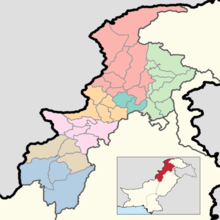 |
| Bannu | ||
| Dera Ismail Khan | ||
| Hazara | ||
| Kohat | ||
| Malakand | ||
| Mardan | ||
| Peshawar | ||