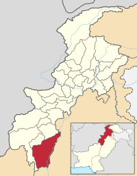
Dera Ismail Khan District
Dera Ismail Khan District (Pashto: ډېره اسماعیل خان ولسوالي, Urdu: ضلع ڈیره اسماعیل خان, Saraiki: ضلع ڈېره اسماعیل خان ; often abbreviated as D.I. Khan) is a district in Dera Ismail Khan Division of Khyber Pakhtunkhwa province in Pakistan. The capital of the district is the town of Dera Ismail Khan. The district has an area of 9,334 km2 (3,604 sq mi) and a population of 852,995 as of the 1998 Census.
Dera Ismail Khan District ضلع ڈیره اسماعیل خان | |
|---|---|
 Map of Dera Ismail Khan | |
| Country | Pakistan |
| Province | Khyber Pakhtunkhwa |
| Founded by | Sardar Ismail Baloch |
| Headquarters | Dera Ismail Khan |
| Government | |
| • District Nazim | Azizullah Alizai (PTI) |
| • District Naib Nazim | Ismail Baloch from Paroa |
| Area | |
| • Total | 9,334 km2 (3,604 sq mi) |
| Population (2017)[1] | |
| • Total | 1,695,688 |
| • Density | 180/km2 (470/sq mi) |
| Time zone | UTC+5 (PST) |
| Main language(s) | Saraiki, Pashto |
Geography
The district of Dera Ismail Khan is bounded on the east by the Bhakkar and Dera Ghazi Khan districts of Punjab. Eastern portions of the district along the Indus River are characterized by fertile alluvial plains, while lands farther from the river consist of clay soil cut by ravines from rainfall. The district is bound on the southwest by a thin strip of South Waziristan district of the Federally Administered Tribal Areas, which separates DI Khan from the Takht-e-Sulaiman Mountain in neighbouring Baluchistan province. In the northwest is the northwest by Tank District.[2]
DI Khan is separated from the Marwat plains of the Lakki Marwat district by a spur of clay and sandstone hills that stretch east from the Sulaiman Mountains to the Indus River known as the Sheikh Badin Hills. The highest peak in the range is the limestone Sheik Badin Mountain, which is protected by the Sheikh Badin National Park. Near the Indus River is a spur of limestone hills known as the Kafir Kot hills, where the ancient Hindu complex of Kafir Kot is located.[2] D I khan is also considered the center of Pakistan because of its location between Bhakkar of South Punjab, Mianwali of North Punjab, Zhob of Balochistan and South Waziristan of Pakistan tribal belt.
Education
There are many educational institutions in the region some of these are highlighted.
- Gomal University Two campuses in Dera Ismail Khan
- St. Helen's High School & College
- Qurtuba University
- Gomal Medical College
- University Wensam College
- Punjab College Meraj Campus
- Dar-e-Arqam School Dera Ismail Khan
- The City School Dera Ismail Khan
- Government College of Technology Dera Ismail Khan campus
- Beaconhouse School System
Overseas Pakistan Foundation School
- Educare School
- Knowledge Home
- LEEDS School & College
Dera Ismail Khan mines
- Dera Ismail Khan mine
- Kathgarh coal mine
History
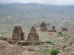
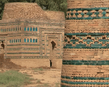
The Dera Ismail Khan District is littered with ruins from ancient civilizations. DI Khan is home to the collection of Hindu ruins at two separate sites 20 miles apart,[2] jointly known as Kafir Kot.
The region came under the influence of the Nanda Empire of ancient India from 300 BCE, and with the rise of Chandragupta Maurya, the region came under the complete control of the Mauryan Empire. Afterward, the region was briefly and nominally controlled by the Shunga Empire. However, with the decline of the Shungas, the region passed to local Hindu and Buddhist rulers, and interrupted by foreign rulers. Many of these foreign rulers, like the Indo-Parthians, Sakas, and Kushans converted to Hinduism and Buddhism, and promoted these Indian religions throughout Central and South Asia. The region reached its height under the Buddhist ruler Kanishka the Great. After the fall of the Kushans, the region came under the control of the Gupta Empire of ancient India. During the period, Hindu and Buddhist art and architecture flourished in the area.[3]
With the decline of the imperial Guptas, the Hindu Shahis came to rule the area. The Hindu Shahis built two massive forts in the northern edges of Dera Ismail Khan. The forts were later renamed as "Kafirkots" (forts of the infidel). These Hindu Shahi forts were known for high towers and steep defensive walls. The Hindus also built many Hindu temples around the area, however, much of them are now in rubble. The Hindu Shahis remained in control of the area until their defeat by the Turkic Muslim army of Ghaznavids.[3]
The district is part of what was historically territory inhabited by the Baluch people during medieval India, who were invited to settle the region by Shah Husseyn, of the Langah Sultanate of Multan. These Baluch settlers were displaced by, or assimilated into, later waves of Pashtun settlement.[2]
DI Khan was created as an administrative unit of British India, part of the Derajat Division of the North-West Frontier Province. It was formerly divided into two almost equal portions by the Indus River, which intersected it from north to south. To the west of the Indus, the characteristics of the country resembled those of Dera Ghazi Khan. To the east of the present bed of the river there is a wide tract known as the Kachi, exposed to river action. Beyond this, the country rises abruptly, and a barren, almost desert plain stretches eastwards, sparsely cultivated, and inhabited by nomadic tribes. In 1901 the trans-Indus tract was allotted to the newly formed North-West Frontier Province, the cis-Indus tract remaining in the Punjab jurisdiction. The cis-Indus portions of the DI Khan and Bannu districts now comprise the new Punjab district of Mianwali. Wheat and wool were exported. In 1901 it contained an area of 8,814 km2 (3,403 sq mi) and a population of 252,379. In 1947 it became part of the newly independent Pakistan.
In 2016, 191,000 acres in the district were brought under cultivation with completion of the Gomal Zam Dam, and a series of irrigation canals partially funded by the United States Government.[4]
Language distribution
The main language of the district is a dialect of Saraiki. Its local name was "Hindko", but the term "Saraiki" has gained popularity in recent decades,[5] alongside a growing identification with the goals of the Saraiki language movement.[6] In the census of 1998, 72.5% of the population reported their first language[7] as Saraiki, while Pashto (primarily spoken in the north-west) accounted for 22.0% and Urdu represented 3.26%.[8]
Politics
The district is represented in the National assembly by Two elected MNAs who represent the following constituencies:[9]
| Constituency | MNA | Party |
|---|---|---|
| NA-38 | Ali Amin Khan | PTI |
| NA-39 | Muhammad Yaqoob Shiekh | PTI |
The district is represented in the provincial assembly by five elected MPAs who represent the following constituencies:[9]
| Constituency | MPA | Party |
|---|---|---|
| PK-95 | Ehtesham Javed Akbar Khan | Independent |
| PK-96 | Ahmad Karim Kundi | Pakistan Peoples Party |
| PK-97 | Faisal Amin Gandapur | PTI |
| PK-98 | Maulana Lutf ur rehman | JUI(F) |
| PK-99 | Aghaz Ikramullah Gandapur | PTI |
- Sobat is a famous dish in Dera Ismail Khan.
- Sohan Halwa of Dera Ismail Khan is considered best in all Pakistan.
- Dhakki Date is famous for its taste and size in whole Pakistan and also transported to many other countries such as India. Bahria Town Islamabad is filled with Dhakki's date.
Sports
Football is a famous game in Dera Ismail Khan. Other games including Cricket, Hockey, Badminton and many more.Ali Amin Khan has also provide platform to better sports in this region.In 2017 he had introduced a Tennis ball cricketleague.league was named as Dera Premiere League and the teams from different geographical regions of Pakistan had competed. Season two will also be held soon in 2018.DPL become the Pakistan's biggest Tape ball cricket tournament. Cricket team of Dera Ismail Khan being Dera Ismail Khan cricket team. Some cultural games(Kabaddi,mailay and most popular is"Kodi"which is played by three sportsmen called Pehlwaan one runs while two other have to catch him in a big circular ground encircled by spectators) are still popular among native Saraiki people since decades.
Administration
The district is subdivided into five tehsils which contain a total of 47 Union Councils:[10]
| Name of tehsil | No. of Unions |
|---|---|
| Dera Ismail Khan | 21 |
| Kulachi | 4 |
| Daraban | 4 |
| Paroa | 7 |
| Paharpur | 11 |
New tehsil has been included in district by merger of FATA that is Darazinda so now it has 6 tehsils
Notable people
Sportsmen
Politicians
- Malik Tahir Waeeem
- Mufti Mahmud
- Shaista Khan Baloch
- Sardar Imtiaz Khan Baloch
- Fazl-ur-Rehman
- Atta ur Rehman Khan
- Ali Amin Khan
- Faisal Karim Kundi
- Sardar Inayatullah Khan Gandapur
- Aurangzeb Khan(Chief minister of NWFP)
- Sardar Abdur Rashid Khan
- Maulana Lutf ur Rehman
- Sami Ullah
- Sardar Ikramullah Gandapur
- Israr Ullah Khan Gandapur
- Umar Farooq Miankhel
- Khalifa Abdul Qayyum
- Mureed Kazim
- Aghaz Ikramullah Gandapur
- Fazal Karim
- Asadullah
- Waqar Ahmed Khan
- Muhammad Yaqoob Sheikh
- Late Javeed Akbar Khan Ex MPA
- Ahtisham Javeed Akbar MPA PK 95
=Others
- Attaullah Khan Atta
- Molana Ahmed Shoaib Khan
- Saeed Ahmad Akhtar
- Mazhar Alam
- Cllr Gohar Almass MEE
- Hector Lachlan Stewart MacLean
- Ved Prakash Malik
- Muhammad Sirajuddin Naqshbandi
- Ghulam Mohammad Qasir
- Edmund Costello
- Sher Shah Suri
- Wing Commander Nouman Ali Khan
- Peer Ahmad Shah
- Waqar Ahmed Seth
- Judge Muhammad Bashir
Entertainment
- Marina Khan
- Musarat Shaheen
See also
References
- "DISTRICT WISE CENSUS RESULTS CENSUS 2017" (PDF). www.pbscensus.gov.pk. Archived from the original (PDF) on 2017-08-29. Retrieved 2017-11-06.
- Tolbort, T (1871). The District of Dera Ismail Khan, Trans-Indus. Retrieved 12 December 2017.
- https://www.google.com/books/edition/Ancient_Pakistan/R4jiAAAAMAAJ?hl=en&gbpv=1&bsq=Dera+Ismail+Khan+hindu+shahi&dq=Dera+Ismail+Khan+hindu+shahi&printsec=frontcover
- https://pk.usembassy.gov/us-government-helping-bring-water-191000-acres-dera-ismail-khan-tank/
- Shackle, Christopher (1980). "Hindko in Kohat and Peshawar". Bulletin of the School of Oriental and African Studies. 43 (3): 484. doi:10.1017/S0041977X00137401. ISSN 0041-977X.
- Shackle, Christopher (1983). "Language, Dialect and Local Identity in Northern Pakistan". In Wolfgang-Peter Zingel; Stephanie Zingel-Avé Lallemant (eds.). Pakistan in its fourth decade: current political, social and economic situation and prospects for the 1980s. Mitteilungen des Deutschen Orient-Instituts. 23. Hamburg: Deutsches Orient-Institut. pp. 175–87.
- defined as the language for communication between parents and children
- 1998 District Census report of Dera Ismail Khan. Census publication. 50. Islamabad: Population Census Organization, Statistics Division, Government of Pakistan. 1999. p. 20.
- Constituencies and MNAs of the National Assembly of the Pakistan
- Tehsils & Unions in the District of D.I. Khan – Government of Pakistan Archived February 9, 2012, at the Wayback Machine
Provincial capital: Peshawar | ||
| Divisions | Districts | 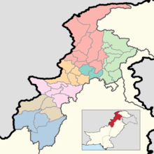 |
| Bannu | ||
| Dera Ismail Khan | ||
| Hazara | ||
| Kohat | ||
| Malakand | ||
| Mardan | ||
| Peshawar | ||