Khuzdar District
Khuzdar (Balochi and Brahui: هزدار،خزدار ; Urdo: خضدار) is a district in the Balochistan province of Pakistan. Its capital is the city of Khuzdar.
Khuzdar District | |
|---|---|
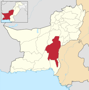 Map of Balochistan with Khuzdar District highlighted | |
| Country | Pakistan |
| Province | Balochistan |
| Established | 1974 |
| Administrative centre | Kalat Division |
| Government | |
| • Commissioner | Mohammad Hashim Ghalzai |
| • Police Commissioner / Deputy Inspector General of Police | Mohammad Zafar Ali |
| Area | |
| • Total | 35,380 km2 (13,660 sq mi) |
| Population (2017)[2] | |
| • Total | 802,207 |
| • Density | 23/km2 (59/sq mi) |
| Time zone | UTC+5 (PST) |
| Number of Tehsils | 4 |
Until its establishment as a district in 1974 it was part of Kalat District. In November 1992 part of the territory of Khuzdar was split off to form the new district of Awaran.[3]
Overview
Towns and cities in Balochistan are not as big as compared to other provinces generally due to scarcity of water and abundance of arid and wastelands. Khuzdar, though one of the important cities of Balochistan is a small sized city located in Khuzdar District in Balochistan, Pakistan. The city of Khuzdar is situated on National Highway linking Pakistan, Iran and Turkey. It is about 400 km from Karachi and 300 km from Quetta, both of them being main cities of the country.
During the Arab rule this region formed the province of Turan and Khuzdar was the capital. It was an important cantonment and was the headquarters of the Arab General Commanding the Indian frontier. Later Khuzdar became a part of the Kalat State. It was the scene of a battle between the people of Jhalawan and the Khan of Kalat in 1869. The Khan of Kalat Mir Khuda Khan was victorious and built here a fort of painted pottery. Close to the town are the ruins of an old fort built by the Arabs. Khuzdar is the capital of Khuzdar district. It is a district and divisional headquarters town in Balochistan. Previously party of the Kalat district, Khuzdar was upgraded as a separate district on 1 March 1974. The district is subdivided into four tehsils: Khuzdar, Zehri, Naal and Wadh. It is at the apex of a narrow valley at an elevation of 1,237 m (4.000 feet). Over 99% of the people of the area are Muslims. The population of Khuzdar district is estimated to be over 525,000 in 2005. The major tribes in the district are Bizenjo, Mardoi Jattak, Hasni, Siapad, Nausherwani, moosiani Zehri, Mengal, Zarakzai, Ahmadzai' Rekizai ' Sasoli ' Kurd' . A large military complex is near completion near Khuzdar, which would make it the second largest Cantonment in Balochistan after Quetta. A university is at the outskirts of Khuzdar,[4] known as the heart of Balochistan. The city of Khuzdar is situated on National Highway linking Pakistan, Iran and Turkey. The city has an airport near the university. The former college, now university is constructed on the foot-hills and is spread over an area of 200 acres (0.81 km2).
Administration
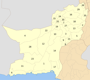
The district is administratively subdivided into five tehsils, which include 34 union councils:[5]
The Union Council for each tehsil is given below:
- Khuzdar – Baghbana, Balina Khattan, Faizabad, Ferozabad, Gazgi, Khand, Parko, Sasol, Tootak, Zeedi, Zerina Khattan
- Moola – Abad KarKh, Moola, Sun Chakoo, Kharzan
- Nall – Durnaili, Goni Gresha, Hazar Ganji, Killi Alam Khan, Kocho, Nal, Ornach, Sar Raij
- Wadh – Arenji, Badari, Loop, Pesi Kapper, Saroona, Shah Noorani, Wadh, Waheer
- Zehri – Chashma, Ghat, Noorgama Zehri
Source: (Local Government, Balochistan, 2005)
Demography
The population in 1998 was 417,000, 28% of which was urban.[6] In 2012 it was estimated to be over 925,000. 99% are Muslim.[7] The majority of the population is made up of Brahui-speaking tribes,[8] and according to the 1981 census Brahui was the first language in 82% of households, followed by Balochi with 13%.[9] In the 1998 census, which did not gather data for Brahui, 96.7% of the population reported their language as Balochi, and 1.0% – as Punjabi.[10]
Education
According to the Pakistan District Education Rankings 2017, district Khuzdar is ranked at number 122 out of the 141 ranked districts in Pakistan on the education score index. This index considers learning, gender parity and retention in the district.
Literacy rate in 2014–15 of population 10 years and older in the district stands at 45% whereas for females it is only 26%.[11]
Post primary access is a major issue in the district with 87% schools being at primary level. Compare this with high schools which constitute only 5% of government schools in the district. This is also reflected in the enrolment figures for 2016–17 with 23,848 students enrolled in class 1 to 5 and only 698 students enrolled in class 9 and 10.
Gender disparity is another issue in the district. Only 30% schools in the district are girls’ schools. Access to education for girls is a major issue in the district and is also reflected in the low literacy rates for females.
Moreover, the schools in the district lack basic facilities. According to Alif Ailaan district education rankings 2017, the district is ranked at number 127 out of the 155 districts of Pakistan for primary school infrastructure. At the middle school level, it is ranked at number 133 out of the 155 districts. These rankings take into account the basic facilities available in schools including drinking water, working toilet, availability of electricity, existence of a boundary wall and general building condition. More than 4 out of 5 schools do not have electricity in them. 1 out 3 schools lack a toilet and 1 out of 2 do not have a boundary wall. 1 out of 3 schools do not have clean drinking water.
The main issues reported in Taleem Do! App for the district is the unavailability of schools. The schools available are reported to have a lack of teachers.
References
- 1998 Census report, p. 1.
- "DISTRICT WISE CENSUS RESULTS CENSUS 2017" (PDF). www.pbscensus.gov.pk. Archived from the original (PDF) on 2017-08-29. Retrieved 2017-09-03.
- 1998 Census report, pp. 1, 8.
- Balochistan University of Engineering & Technology Khuzdar
- "Tehsils & Unions in the District of Khuzdar - Government of Pakistan". Archived from the original on 2008-05-28. Retrieved 2008-02-18.
- 1998 Census report, pp. 15, 18.
- 1998 Census report, p. 18.
- 1998 Census report, p. 8.
- These figures are for the combined population of Khuzdar and Wadh subdivisions and excludes the Awaran subdivision (1981 Census report, p. 84).
- 1998 Census report, pp. 19–20.
- Pakistan Bureau of Statistics (2016). Pakistan Social and Living Standards Measurement Survey 2014-15. [online] Islamabad: Government of Pakistan, p.111. Available at: http://www.pbs.gov.pk/sites/default/files//pslm/publications/PSLM_2014-15_National-Provincial-District_report.pdf [Accessed 6 Aug. 2018].
Bibliography
- 1981 District census report of Khuzdar. Census publication. 12. Islamabad: Population Census Organization, Statistics Division, Government of Pakistan. 1983.
- 1998 District census report of Khuzdar. Census publication. 108. Islamabad: Population Census Organization, Statistics Division, Government of Pakistan. 2000.
External links
| Wikimedia Commons has media related to Khuzdar District. |