Kasur District
Kasur District or Qasoor District (Punjabi and Urdu: ضِلع قصُور), is a district located in Lahore Division of Punjab, Pakistan. It came into existence on 1 July 1976.[1]:1 Prior to its creation, it was a tehsil of the Lahore District.
Kasur District ضِلع قصُور Qasoor District | |
|---|---|
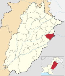 Location of Kasur District (highlighted in red) within Punjab. | |
| Country | |
| Province | |
| Headquarters | Kasur |
| Government | |
| • District Coordination Officer | Saira Omer |
| • District council chairman | Rana Sikandar Hayat |
| Area | |
| • Total | 3,995 km2 (1,542 sq mi) |
| Population (2017)[2] | |
| • Total | 3,454,996 |
| • Density | 860/km2 (2,200/sq mi) |
| Time zone | UTC+5 (PST) |
| Tehsils | Kasur Kot Radha Kishan Pattoki Chunian |
The district capital is Kasur city, the birth city of the Sufi poet Bulleh Shah, who is well known in that region as well as in the whole of Pakistan. The total area of the district is 4,796 square kilometres.[3]
History
In ancient time, Kasur was known for its education and fish. The history of Kasur is more than 1,000 years. Kasur region was agricultural region with forests during the Indus Valley Civilization. The Vedic period is characterized by Indo-Aryan culture that migrated from Central Asia and settled in Punjab region. The Kambojas, Daradas, Kaikayas, Pauravas, Yaudheyas, Malavas and Kurus migrated, settled and ruled ancient Punjab region. After overrunning the Achaemenid Empire in 331 BCE, Alexander marched into present-day Punjab region with an army of 50,000. The Kasur region was ruled by Maurya Empire, Indo-Greek kingdom, Kushan Empire, Gupta Empire, White Huns, Kushano-Hephthalites and Shahi kingdoms.
In 997 CE, Sultan Mahmud Ghaznavi, took over the Ghaznavid dynasty empire established by his father, Sultan Sebuktegin, In 1005 he conquered the Shahis in Kabul in 1005, and followed it by the conquests of Punjab region. The Delhi Sultanate and later Mughal Empire ruled the region. The Punjab region became predominantly Muslim due to missionary Sufi saints whose dargahs dot the landscape of the Punjab region.
The Mughal Empire ruled Kasur for 200 years. After and during the decline of the Mughal Empire, the Sikhs took over the Kasur District. The agriculture lands were given to leaders and supporters of the Sikh army. Most of the Punjab region was annexed by the East India Company in 1849, and was one of the last areas of the South Asia to fall under British colonial rule. During the British Raj, the irrigation canals were built that irrigated large areas barren lands of the Kasur District.
The predominantly Muslim population supported Muslim League and Pakistan Movement. After the independence of Pakistan in 1947, the minority Hindus and Sikhs migrated to India while the Muslim refugees from India settled in the Kasur District.
Demography
According to the 1998 census, Punjabi is the most widely spoken first language[4] (88%), whereas Urdu was the first language of 6.2% of the population. The district is unusual in that Urdu accounts for a greater proportion of speakers in rural (7.3%) than in urban areas (2.6%).[1]:23–24
Development
The Bambawali-Ravi-Bedian Canal was built in Kasur district increasing the agricultural development of the area. There has been commercial and industrial development but the area remain mainly agricultural. Pakistan Army built Cantonment area for an infantry brigade in the district.
Administrative divisions
The district is administratively subdivided into 4 tehsils[5] and 125 Union Councils:[6] the total area of ksur is 3995 km2
Physical features
The district is bounded by the Ravi River in the north-west and river Sutlej in the south-east. Whereas the old course of Beas River bifurcates the district into two equal parts locally known as Hither and Uthar or Mithan Majh. Both of the areas have a height differential of approximately 5.5 meters. The natural surface elevation of the district is 198 meters above the sea level, having a general slope from north-east to south- west. Whereas the east and west ends of the district comprise the flood plains of the rivers Satluj and Ravi, characterized by breaching of looping river Channels braided around meander bars. Kasur district is attached with Lahore from east, attached with Nankana Sahib from north, attached with Faisalabad from west and attached with Okara and India from south.
Topography
Topographically speaking, Kasur District lies between the river Satluj which flows along its boundaries with India and river Ravi which flows its boundary with Nankana Sahib District. The districts may be divided into two parts, a low lying or riverine area along the two bordering rivers and upland, away from the rivers. The riverine area is generally inundates during monsoon season. The water level in this area is higher than in the upland. The soil is sandy. The upland is flat plains sloping from north-west to south-west. The general height of the area is from 150 to 200 meters above the sea level.
Flora
Flora of the district has been greatly modified by human agency of the old open forests of small trees and shrubs; there remains only a few Rakhs or portions of forest which are kept as gazing ground for cattle etc. Amongst trees the most important are Kikar (Acacia arabica), Shisham or Tahli (Dalbergia sissoo), Beri (Zizyphus jajaba), Toot (Morus marlaccae), Sharin (Albizzia lebbek), Dharek (Malia azerdaracb), Phulahi (Acacia modesta), and Nim (Melia indica), Piple (Ficus indica) are planted for shade. The growth in Rakhs is composed mainly of three kinds of trees Jand (Prosopis spicigera), Karril (Capparis aphylla), and van or Jal (Salvadora obeoides). Occasionally pelu (acacia Loucophhloea) and Farash (Tamarix articulate) are also found. Pilchi (Tamarix gallio) is found on moist sandy soil along the rivers and is used for wicker-work, basket making etc.
Fauna
Wolf and jackal are the only wild animals of any importance. The former being met with occasionally in the low land wastes of Chunian Tehsil but jackal are found every where. Changa Manga reserve a thick forest is the only area in which a few Nelgai, pig, peafowl and here are found.
Places of interest
Kasur is adjacent to the border. It is a major tourist attraction because of the famous guard changing ceremony. Kasur is also famous for Kasuri Methi Kasuri Fish Kasuri Andrasy. The city is also the resting place of Sufi poet Bulleh Shah. Kasur is famous for its very tasty fish, a sweet dish called Andrassay, Falooda and Kasuri Methi.
- Balloki is famous for Ravi River is in Balloki. Many of the people came for visit of this village. Balloki Power Plant is also situated in Balloki.
- Phool Nagar industrial area
- Pattoki is the 7th dense industrial area of Pakistan
- Chunian is famous for its sugar mills. Abdullah sugar mill is the largest sugar mill of Pakistan
- Kot Radha Kishan is famous for being related to lord Kirashan and his beloved Radha (of hindu-ism) and industries
- Changa Manga The largest forest of Pakistan
The following are places of interest in the district:
- Shrine of Baba Bulleh Shah, Kasur City
- Shrine of Baba Sadar Dwan, Kasur city
- Kasur Railway Junction
- Kasur Museum
- Tomb Hazrat Baba Kamal Cishti in Kasur city
- Ganda Singh Wala Border, Pakistan-India Border
- Balloki Headworks & many resorts
- Changa Manga Forest, near Chunian Town
- Shrine of Hazrat Abdullah Shah Bukhari (Baba Sha Jhanda), near Pattoki city in the village also named after him
- Gurdwara Hardo Sahari and Samadh Pir Sahari Chhina Jatt. Village Hardo Sahari
Qadiwind is a historically significant to the Sikh religion. After the independence in 1947 the Sikhs there emigrated to East Punjab in India. Punjabi writer Baba Sohan Singh Sital was a resident of this village. His house and garden area was allotted to Muslim refugees from Mewat who came as part of independence. The majority population consists of Meo or Mewatis who migrated to 1947.[7]
Notable people
- Aseff Ahmad Daula, former Foreign Minister (PPPP)
- Tahir Aslam Gora, Pakistan-Canadian writer, broadcaster and translator.[8]
- Noor Jehan, playback singer and actress
- Ahmad Raza Khan Kasuri, former MNA.[8]
- Khurshid Mahmud Kasuri, former Foreign Minister and now member of PTI
- Malik Meraj Khalid, Speaker of the National Assembly twice, and Prime Minister of Pakistan in 1997.
- Bade Ghulam Ali Khan, Indian classical vocalist.[8]
- Barkat Ali Khan, classical vocalist.[8]
- Rana Muhammad Iqbal Khan, Pakistani politician who was the Speaker of the Provincial Assembly of the Punjab from 2008 to May 2018. Now MPA.
- Sardar Tufail Ahmad Khan, former MPA and MNA, Parliamentary Secretary and Chairman standing committee.
- Sardar Muhammad Arif Nakai, Ex-Chief Minister of Punjab, Pakistan.
- Bebe Nanaki, sister of Guru Nanak
- Moeenuddin Ahmad Qureshi Ex-vice-President of World Bank and Prime Minister of Pakistan in 1993.
References
- 1998 District Census report of Kasur. Census publication. 112. Islamabad: Population Census Organization, Statistics Division, Government of Pakistan. 2000.
- "DISTRICT WISE CENSUS RESULTS CENSUS 2017" (PDF). www.pbscensus.gov.pk. Archived from the original (PDF) on 29 August 2017. Retrieved 3 September 2017.
- "Kasur Police". Archived from the original on 4 January 2008. Retrieved 16 September 2008.
- "Mother tongue": defined as the language of communication between parents and children.
- List of Tehsils Archived 2010-12-30 at the Wayback Machine
- Tehsils & Unions in the District of Kasur Archived 2011-08-07 at the Wayback Machine
- "Gurudwara Bhai Bahlol at Qadiwind, Distt Kasur - Gateway to Sikhism". Allaboutsikhs.com. Retrieved 15 January 2013.
- Important Personalities Kasur District, official district website. Retrieved 24 October 2019
Provincial capital: Lahore | ||
| Bahawalpur | .png) | |
| Dera Ghazi Khan | ||
| Faisalabad | ||
| Gujranwala | ||
| Lahore | ||
| Multan | ||
| Rawalpindi | ||
| Sargodha | ||
| Sahiwal | ||
| Sheikhupura | ||
See also: Districts of Punjab, India | ||
Neighbourhoods of Kasur | ||
|---|---|---|
Administration: Kasur District | ||
| Tehsils |  | |
| Cities |
| |
| Towns and councils |
| |
| Localities |
| |
Website: Kasur District at NRB | ||