Sargodha District
Sargodha District (Urdu: ضِلع سرگودها), is a district of Punjab, Pakistan. The capital of the district is Sargodha. It is an agricultural district, wheat, rice, and sugarcane being its main crops. The Sargodha district and region is also famous for citrus fruit including Kinnow, orange and lemon. The district has an area of 5,864 km2.[3]
Sargodha District ضِلع سرگودها | |
|---|---|
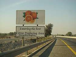 M-2 Motorway entering Sargodha District | |
 Flag  Seal | |
 Location of Sargodha District in Punjab | |
| Country | |
| Province | |
| Division | Sargodha |
| Headquarters | Sargodha |
| Government | |
| • Type | District Administration |
| • Deputy Commissioner | Abdullah Nayyar Sheikh |
| • Assistant Commissioner(s) | 7 ACs[1] |
| Area | |
| • District | 5,854 km2 (2,260 sq mi) |
| Population (2017)[2] | |
| • District | 3,903,588 |
| • Density | 670/km2 (1,700/sq mi) |
| • Urban | 1,091,045 |
| Time zone | UTC+5 (PST) |
| Postal Code | 40100 |
| Constituencies | NA-88, NA-89, NA-90, NA-91, NA-92 |
| Number of Tehsils | 7 |
| Website | http://www.sargodha.gop.pk/ |
Administration and Tehsils
Sargodha District is the administrative headquarter of Sargodha Division and handles the population of about 8.1 million.[2] Sargodha District is administratively divided into Seven Tehsils, which contain a total of 161 Union Councils,[4] population according to the 1998 census of Pakistan:[5]
| Tehsil | Population (1998) | No. of Unions |
|---|---|---|
| Bhera | 100,000 | 15 |
| Bhalwal | 820,000 | 53 |
| Kot Momin | 420,000 | 30 |
| Sahiwal | 236,001 | 14 |
| Sargodha | 1,081,000 | 62 |
| Shahpur | 274,000 | 16 |
| Silanwali | 255,000 | 16 |
Demographics
The population of Sargodha grew rapidly with the arrival of Muslim refugees from East Punjab, fleeing from the religious violence that followed the partition of India and the independence of Pakistan in 1947. According to the 1998 census of Pakistan the district had a population of 2,665,979 of which 27.96% lived in urban settlements.[6]
The most widely spoken language of the district is Punjabi, which according to the 1998 census is the first language[7] of 93% of the population, and Urdu – of 6%.[8]
Etymology
It is believed that there was an old pond in the middle of the town where an old Hindu monk or sadhu (godha) used to live. The Hindi word for pond is "ser".[9] Since the town had a modest population, people would refer the place as sergodha, the place where that famous Sadhu resided next to the pond.[10]
References
- https://m.facebook.com/deputycommissionersgd/
- "DISTRICT WISE CENSUS RESULTS CENSUS 2017" (PDF). www.pbscensus.gov.pk. Archived from the original (PDF) on 29 August 2017.
- District Wise – Sargodha Archived 2008-01-04 at Archive.today
- Tehsils & Unions in the District of Sargodha – Government of Pakistan Archived 9 February 2012 at the Wayback Machine. Nrb.gov.pk. Retrieved on 2012-07-01.
- 1998 Census figures. pportal.punjab.gov.pk
- Urban Resource Centre. urckarachi.org
- "Mother tongue": defined as the language of communication between parents and children and recorded of each individual.
- 1998 District Census report of Sargodha. Census publication. 36. Islamabad: Population Census Organization, Statistics Division, Government of Pakistan. 1999.
- Portrait of Pakistan. Ferozsons. Retrieved 31 December 2007.
The district derives its name for the headquarters town of Sargodha, which is a combination of "Sar" and "Godha". "Sar" is a Hindi word which denotes a water...
- Pakistan tourism directory. Holiday Weekly. Retrieved 31 December 2007.
Sargodha is a colony town established in 1903, but its origins are older. Sargodha is a combination of the words "Sar" meaning a pond and "Godha"...
Neighbourhoods of Sargodha | ||
|---|---|---|
Administrations: Sargodha Division and Sargodha District | ||
| Tehsils | 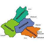 | |
| Cities |
| |
| Towns & councils | ||
| Localities |
| |
Website: Sargodha District at NRB | ||
Provincial capital: Lahore | ||
| Bahawalpur | .png) | |
| Dera Ghazi Khan | ||
| Faisalabad | ||
| Gujranwala | ||
| Lahore | ||
| Multan | ||
| Rawalpindi | ||
| Sargodha | ||
| Sahiwal | ||
| Sheikhupura | ||
See also: Districts of Punjab, India | ||