Dera Ghazi Khan District
Dera Ghazi Khan (ضِلع ڈيره غازى خان) is a district in the Punjab province of Pakistan. Its capital is Dera Ghazi Khan city.
Dera Ghazi Khan District ضِلع ڈيره غازى خان | |
|---|---|
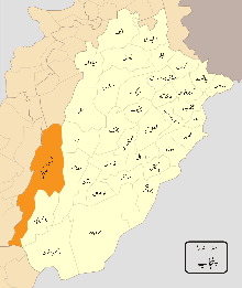 Location of Dera Ghazi Khan District (highlighted in orange) within Punjab. | |
| Country | |
| Province | |
| Divsion | Dera Ghazi Khan |
| Headquarters | Dera Ghazi Khan |
| Government | |
| • Commissioner | Mudasir Riaz |
| • Mayor | Shahid Hameed Chandia |
| • MNAs | Zartaj Gul(Constituency NA-191) |
| Area | |
| • Total | 11,294 km2 (4,361 sq mi) |
| Population | |
| • Total | 2,872,201 |
| • Density | 250/km2 (660/sq mi) |
| Time zone | UTC+5 (PST) |
| Number of Tehsils | 4 |
| Website | http://dgkhan.gop.pk/ |
The Sulaiman Mountains rise to a height of 10,000 feet (3,000 m) in the north of the district.[3]
Administration
The district is divided into Four tehsils [4][5] which are divided into a total of sixty Union Councils:[6]
| Tehsil | No. of Unions |
|---|---|
| Dera Ghazi Khan | 41 |
| Taunsa | 24 |
| Koh-e-sulaiman | 01 |
History
The city was founded at the close of the 15th century and named after Nawab Ghazi Khan Mirani, son of Nawab Haji Khan Mirani, a Balochi chieftain, who had declared independence from the Langah Dynasty's Sultans of Multan.[7] Together with two other Deras i.e. settlements, Dera Ismail Khan and Dera Fateh Khan, it gave its name to Derajat. Derajat eventually came into the possession of the British after the Sikh War in 1849 and was divided into two districts: Dera Ghazi Khan and Dera Ismail Khan.[7] After the independence, many of the city's Hindu residents settled in Derawal Nagar colony of Delhi, India.[8] The district of Rajanpur was later carved out of the Dera Ghazi Khan district.
Based on the surveys of 2004–2005, Dera Ghazi Khan district is considered one of the twenty poorest districts of Pakistan with about 51% of its population living under the poverty line.[9]
Dera Ghazi Khan Tehsil
As well as being district capital, Dera Ghazi Khan is also the capital of U/C Sabra Nachan.. Dera Ghazi Khan Tehsil, an administrative subdivision of the district. The city of Dera Ghazi Khan is itself administratively subdivided into seven Union Councils.[10]
Demography
According to the 1998 census, the most widely used first language[11] is Saraiki, spoken by 80% of the population, followed by Balochi with 14%, Urdu with 3.2% and Punjabi with 1.3%.[12]:21
See also
References
- https://www.punjab.gov.pk/dg_khan
- "DISTRICT WISE CENSUS RESULTS CENSUS 2017" (PDF). www.pbscensus.gov.pk. Archived from the original (PDF) on 29 August 2017. Retrieved 3 September 2017.
- Dera Ghazi Khan District – Imperial Gazetteer of India, v. 11, p. 248
- "Tehsils & Unions in the District of D.G. Khan – Government of Pakistan". Nrb.gov.pk. Archived from the original on 9 February 2012. Retrieved 24 March 2012.
- Pakistan Government – List of Tehsils Archived 5 March 2010 at the Wayback Machine
- Tehsils & Unions in the District of D.G. Khan Archived 9 February 2012 at the Wayback Machine
- Chisholm, Hugh, ed. (1911). . Encyclopædia Britannica. 8 (11th ed.). Cambridge University Press. p. 64.
- "Colonies, posh and model in name only!". NCR Tribune. Retrieved 16 December 2007.
- Haroon Jamal (June 2007). Income Poverty at District Level: An Application of Small Area Estimation Technique (PDF) (Report). Social Policy and Development Centre. pp. 15–18. Archived from the original (PDF) on 1 February 2014. Retrieved 28 January 2014.
- "Tehsils & Unions in the District of D.G. Khan – Government of Pakistan". Nrb.gov.pk. Archived from the original on 9 February 2012. Retrieved 24 March 2012.
- "Mother tongue": defined as the language of communication between parents and children, and recorded of each individual.
- 1998 District Census report of Dera Ghazi Khan. Census publication. 44. Islamabad: Population Census Organization, Statistics Division, Government of Pakistan. 1999.
Location
Places adjacent to Dera Ghazi Khan District | ||||||||||
|---|---|---|---|---|---|---|---|---|---|---|
| ||||||||||
External links
| Wikivoyage has a travel guide for Punjab (Pakistan). |
Provincial capital: Lahore | ||
| Bahawalpur | .png) | |
| Dera Ghazi Khan | ||
| Faisalabad | ||
| Gujranwala | ||
| Lahore | ||
| Multan | ||
| Rawalpindi | ||
| Sargodha | ||
| Sahiwal | ||
| Sheikhupura | ||
See also: Districts of Punjab, India | ||