Kharmang District
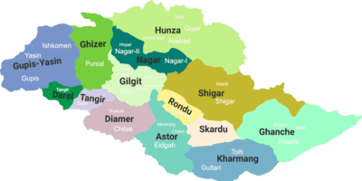
Kharmang District (Urdu:ضلع کھرمنگ) is a political sub-division of Pakistan. It is part of Baltistan and currently constitutes one of the ten districts of the Gilgit–Baltistan territory of Pakistan. It is bounded on the south by the Kargil and Leh of Ladakh, on the northeast by Ghanche District, on the north by Skardu District, and on the west by Astore District.
Kharmang District | |
|---|---|
 Districts of Gilgit-Baltistan (PAKISTAN) | |
| Coordinates: 34°56′40″N 76°13′21″E | |
| Country | Pakistan |
| Province | Gilgit-Baltistan |
| Headquarters | Gohari Madhupur & Madhupur |
| Area | |
| • Total | 7,909 km2 (3,054 sq mi) |
| Population | |
| • Estimate (1998) | 188,000 |
| Time zone | UTC+5:00 (PST) |
Kharmang District includes Kharmang Valley, one of the five main valleys in Baltistan region. The valley is 100 kilometres (62 mi) south-east of Skardu.
Education
According to Alif Ailaan Pakistan District Education Rankings 2017, Kharmang was ranked 119 out of 155 in school infrastructure and facilities score.[1]
References
- "Pakistan District Education Rankings 2017" (PDF). elections.alifailaan.pk. Retrieved 17 August 2019.
| Passes | |
|---|---|
| Valleys |
|
| Cities and towns |
|
| Rivers, glaciers and lakes | |
| Architecture | |
| See also | |
This article is issued from Wikipedia. The text is licensed under Creative Commons - Attribution - Sharealike. Additional terms may apply for the media files.