Madhyamgram railway station
Madhyamgram railway station is the railway station in the town of Madhyamgram. It serves the local areas of Madhyamgram, Badu and Sajirhat in the North 24 Parganas district, West Bengal, India. Many people use it every day, especially to travel to Kolkata during the peak periods. The Sodepur Road connects B.T. Road and Jessore Road through Madhyamgram.
Madhyamgram | |||||||||||
|---|---|---|---|---|---|---|---|---|---|---|---|
| Kolkata Suburban Railway Station | |||||||||||
 Madhyamgram railway station | |||||||||||
| Location | Madhyamgram, North 24 Parganas district, West Bengal India | ||||||||||
| Coordinates | 22.6946°N 88.4528°E | ||||||||||
| Elevation | 13 metres (43 ft) | ||||||||||
| Owned by | Indian Railways | ||||||||||
| Operated by | Eastern Railway | ||||||||||
| Platforms | 3 | ||||||||||
| Tracks | 3 | ||||||||||
| Construction | |||||||||||
| Structure type | At Grade | ||||||||||
| Parking | Not available | ||||||||||
| Other information | |||||||||||
| Status | Functional | ||||||||||
| Station code | MMG | ||||||||||
| Zone(s) | Eastern Railway | ||||||||||
| Division(s) | Sealdah | ||||||||||
| History | |||||||||||
| Opened | 1906 | ||||||||||
| Electrified | 1972 | ||||||||||
| Services | |||||||||||
| |||||||||||
| Location | |||||||||||
 Location of Madhyamgram railway station in West Bengal | |||||||||||
History
The main line of the Eastern Bengal Railway from Sealdah to Ranaghat, was opened in 1862 and extended the same year to Kushtia, now in Bangladesh.[1][2][3] In 1882–84 the Bengal Central Railway Company constructed two lines: one from Dum Dum to Khulna, now in Bangladesh, via Bangaon and the other linking Ranaghat and Bangaon.[2] The Madhyamgram railway station lies in the Dum Dum-Bangaon section and was opened in 1906..
Electrification
The Sealah-Dum Dum-Barasat-Ashok Nagar-Bangaon sector was electrified in 1972.[4]
Station complex
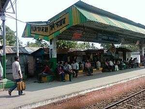
The structure of the station is not so large. There is only one entrance in platform no. 1. The computerised ticket counter is present in platform no. 1. All the Sealdah and Dum Dum bound trains arrive at platform no.1 and all the Bangaon, Gobardanga, Thakurnagar, Habra, Duttapukur, Basirhat and Hasnabad bound trains arrive at platform no. 2 and 3. There are many food stalls and vendors on both the platforms. A foot over bridge connects the two platforms. A level crossing exists at the southernmost end of the railway station. There is a Road Over Bridge to the north of the station and to the south, there exists the bridge over the Noai Canal.
Station layout
| G | Street Level | Exit/Entrance & Ticket Counter |
| P1 | FOB, Side platform, No-1 doors will open on the left/right | |
| Track 1 | Towards →Sealdah→ → | |
| Track 2 | → Towards ←Bangaon← ← | |
| FOB, Island platform, No- 2 doors will open on the left/right | ||
| Island platform, No- 3 doors will open on the left/right | ||
| Track 3 | ||
Metro Railway
Extension plan from Noapara to Barasat
The proposed Metro railway extension (Line 4) alignment pass through Dum Dum Cantonment and Jessore Road up to Biman Bandar station. From there, the line would run under Jessore Road until New Barrackpore before reaching the surface at Madhyamgram station. From Madhyamgram to Barasat, the alignment would be elevated. However, for crossing the existing Road Over Bridge at Madhyamgram and Barasat, the alignment would descend gradually to ground level and rise again on viaduct. This is supposed to be beneficial for the people of North 24 Parganas district and will bring them closer to Kolkata's Business district. This would reduce the heavy pressure on Sealdah–Barasat section of Eastern Railways. The Madhyamgram Metro railway station is to be constructed in the Madhyamgram-Barasat section.[5][6]
Work for the Noapara–Barasat (via NSC Bose Airport) metro extension has come to a halt as construction giant L&T has pulled out of the 17 km metro corridor project. L&T was unable to get on with the work due to the encroachment on railway land. L&T has moved out all major equipment from the project site at Barasat and has closed down two of the three site offices. The lone site office is locked.[7]
Madhyamgram track layout | |||||||||||||||||||||||||||||||||||||||||||||||||||||||||||||||||||||||||||||||||||||||||||||||||||||||||||||||||||||||
|---|---|---|---|---|---|---|---|---|---|---|---|---|---|---|---|---|---|---|---|---|---|---|---|---|---|---|---|---|---|---|---|---|---|---|---|---|---|---|---|---|---|---|---|---|---|---|---|---|---|---|---|---|---|---|---|---|---|---|---|---|---|---|---|---|---|---|---|---|---|---|---|---|---|---|---|---|---|---|---|---|---|---|---|---|---|---|---|---|---|---|---|---|---|---|---|---|---|---|---|---|---|---|---|---|---|---|---|---|---|---|---|---|---|---|---|---|---|---|---|
| |||||||||||||||||||||||||||||||||||||||||||||||||||||||||||||||||||||||||||||||||||||||||||||||||||||||||||||||||||||||
Station with three tracks and one side platforms and two Island platform | |||||||||||||||||||||||||||||||||||||||||||||||||||||||||||||||||||||||||||||||||||||||||||||||||||||||||||||||||||||||
See also
External links
- Madhyamgram railway station map

- Google. "Madhyamgram Railway station" (Map). Google Maps. Google.
References
- R.P. Saxena. "Indian Railway History timeline". IRFCA. Archived from the original on 14 July 2012. Retrieved 10 February 2012.
- "The Chronology of Railway development in Eastern Indian". railindia. Archived from the original on 16 March 2008. Retrieved 10 February 2012.
- J.H.E.Garrett. "Nadia, Bengal District Gazetteers (1910)". IRFCA. Retrieved 10 February 2012.
- "History of Electrification". IRFCA. Retrieved 28 August 2017.
- "Kolkata Metro Official Map".
- "Barasat Metro Progressing".
- "End of the road for Noapara–Barasat metro extension" (Web page). TOI. Times Of India, Kolkata. 2012. Retrieved 25 December 2012.
Railway stations in West Bengal | |
|---|---|
| Eastern Railway |
|
| South Eastern Railway |
|
| North East Frontier Railway |
|
| See also |
|