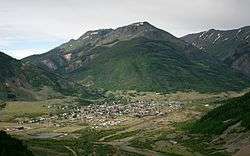
Silverton, Colorado
The town of Silverton is a Statutory Town that is the county seat of, and the only incorporated municipality in San Juan County, Colorado, United States.[8] Silverton is a former silver mining camp, most of which is now included in a federally designated National Historic Landmark District, the Silverton Historic District. The town population reached 637 in the U.S. Census 2010.[9]
Town of Silverton, Colorado | |
|---|---|
 | |
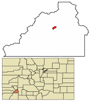 Location of Silverton in San Juan County, Colorado. | |
| Coordinates: 37°48′45″N 107°39′47″W | |
| Country | |
| State | |
| County[1] | San Juan County - seat[2] |
| Established | 1874 |
| Incorporated | November 15, 1885[3] |
| Government | |
| • Type | Statutory Town[1] |
| • Mayor | Shane Fuhrman |
| Area | |
| • Total | 0.85 sq mi (2.19 km2) |
| • Land | 0.85 sq mi (2.19 km2) |
| • Water | 0.00 sq mi (0.00 km2) |
| Elevation | 9,318 ft (2,840 m) |
| Population (2010) | |
| • Total | 637 |
| • Estimate (2018)[6] | 694 |
| • Density | 743.80/sq mi (287.05/km2) |
| Time zone | UTC-7 (Mountain (MST)) |
| • Summer (DST) | UTC-6 (MDT) |
| ZIP code[7] | 81433 (PO Box) |
| Area code(s) | 970 |
| FIPS code | 08-70580 |
| GNIS feature ID | 0204750 |
| Website | Town of Silverton |
Silverton is linked to Durango by the Durango and Silverton Narrow Gauge Railroad, a National Historic Landmark. Silverton no longer has active mining, but subsists by tourism, maintenance of US 550 (which links Montrose with Durango via Silverton), mine pollution remediation, and retirees. In 2002 an extreme ski mountain, Silverton Mountain, opened near the town.[10]
Geography
According to the United States Census Bureau, the town has a total area of 0.8 square miles (2.1 km2), all of it land. Silverton is one of the highest towns in the United States, at 9,318 feet (2,836 m) above sea level.
Climate
Silverton has an alpine subarctic climate (Köppen climate classification Dfc) with very cold, snowy winters and cool to warm summers with adequate precipitation year-round.
| Climate data for 1906-2005 Silverton, Colorado. | |||||||||||||
|---|---|---|---|---|---|---|---|---|---|---|---|---|---|
| Month | Jan | Feb | Mar | Apr | May | Jun | Jul | Aug | Sep | Oct | Nov | Dec | Year |
| Average high °F (°C) | 34.0 (1.1) |
36.6 (2.6) |
40.6 (4.8) |
47.3 (8.5) |
57.6 (14.2) |
67.9 (19.9) |
73.1 (22.8) |
70.5 (21.4) |
64.7 (18.2) |
55.1 (12.8) |
43.2 (6.2) |
35.1 (1.7) |
52.2 (11.2) |
| Average low °F (°C) | −1.9 (−18.8) |
1.0 (−17.2) |
8.1 (−13.3) |
18.5 (−7.5) |
26.4 (−3.1) |
31.9 (−0.1) |
37.9 (3.3) |
37.2 (2.9) |
30.3 (−0.9) |
22.0 (−5.6) |
9.5 (−12.5) |
0.2 (−17.7) |
18.4 (−7.6) |
| Average precipitation inches (mm) | 1.68 (43) |
1.75 (44) |
2.30 (58) |
1.72 (44) |
1.46 (37) |
1.39 (35) |
2.72 (69) |
3.10 (79) |
2.81 (71) |
2.34 (59) |
1.49 (38) |
1.73 (44) |
24.50 (622) |
| Average snowfall inches (cm) | 25.8 (66) |
25.3 (64) |
28.4 (72) |
17.3 (44) |
4.3 (11) |
0.3 (0.76) |
0.0 (0.0) |
0.0 (0.0) |
0.9 (2.3) |
8.5 (22) |
20.0 (51) |
24.0 (61) |
154.9 (393) |
| Source: The Western Regional Climate Center[11] | |||||||||||||
History
Silverton Historic District | |
 Grand Imperial Hotel, Silverton Historic District | |
  | |
| Location | Silverton, Colorado |
|---|---|
| Area | 530 acres (210 ha) (original) 695 acres (281 ha) (after increase) |
| Built | 1882 |
| Architect | Multiple |
| Architectural style | Late Victorian (original) Other (increase) |
| NRHP reference No. | 66000255 (original) 97000247[12] (increase) |
| Significant dates | |
| Added to NRHP | October 15, 1966 |
| Boundary increase | April 03, 1997 |
| Designated NHLD | July 04, 1961[13] |
Charles Baker's group of prospectors found traces of placer gold in the San Juan Mountains in 1860 at Eureka, Colorado. Forced out by the Ute Tribe in 1861, who had been awarded the area in a US treaty. The prospectors returned in 1871, when lode gold was found in the Little Giant vein at Arrastre Gulch. The miners were allowed to stay after the Brunot Treaty of 13 September 1873. In exchange for giving up four million acres (6,200 sq mi; 16,000 km2), the Southern Ute Indian Reservation received $25,000 per year (or about $534,000 per year today, adjusted for inflation).[14]:49
In August 1873, George Howard and R. J. McNutt discovered the Sunnyside silver vein along Hurricane Peak. Gold was then discovered in 1882. The Sunnyside Mine was shut down after the 1929 stock market crash, but was acquired by Standard Metals Corp. in 1959, and reopened, finding gold in 1973 with the Little Mary vein. Half of Colorado's gold production in the 1970s came from the Sunnyside. Disaster occurred on 4 June 1978, when the water from Lake Emma collapsed a mine shaft (when miners weren't present), and then traveled quickly through the tunnels, finally shooting out of a portal along Cement Creek with a force that toppled a 20-ton locomotive.[15] The mine reopened after two years, but was acquired by Echo Bay Mines in 1986, which operated the mine for another five years.[14]:50–51,60,123[16] The nearby Gold King mine breached and spilled into Cement Creek, causing the 2015 Gold King Mine waste water spill.
In the early 1960s Kendall Mountain Ski Area opened by the Grand Imperial Hotel.
Demographics
| Historical population | |||
|---|---|---|---|
| Census | Pop. | %± | |
| 1900 | 1,360 | — | |
| 1910 | 2,153 | 58.3% | |
| 1920 | 1,150 | −46.6% | |
| 1930 | 1,301 | 13.1% | |
| 1940 | 1,127 | −13.4% | |
| 1950 | 1,375 | 22.0% | |
| 1960 | 822 | −40.2% | |
| 1970 | 797 | −3.0% | |
| 1980 | 794 | −0.4% | |
| 1990 | 716 | −9.8% | |
| 2000 | 531 | −25.8% | |
| 2010 | 637 | 20.0% | |
| Est. 2018 | 694 | [6] | 8.9% |
| U.S. Decennial Census[17] | |||
As of the census[18] of 2000, there were 531 people, 255 households, and 149 families residing in the town. The population density was 656.0 people per square mile (253.1/km²). There were 430 housing units at an average density of 531.2 per square mile (205.0/km²). The racial makeup of the town was 97.36% White, 0.75% Native American, 0.38% Pacific Islander, 0.75% from other races, and 0.75% from two or more races. Hispanic or Latino of any race were 7.72% of the population.
There were 255 households out of which 24.7% had children under the age of 18 living with them, 43.5% were married couples living together, 9.4% had a female householder with no husband present, and 41.2% were non-families. 36.9% of all households were made up of individuals and 4.7% had someone living alone who was 65 years of age or older. The average household size was 2.06 and the average family size was 2.63.
In the town, the population was spread out with 20.7% under the age of 18, 4.0% from 18 to 24, 28.4% from 25 to 44, 39.9% from 45 to 64, and 7.0% who were 65 years of age or older. The median age was 44 years. For every 100 females, there were 108.2 males. For every 100 females age 18 and over, there were 110.5 males.
The median income for a household in the town was $30,486, and the median income for a family was $39,375. Males had a median income of $30,588 versus $19,886 for females. The per capita income for the town was $16,839. About 14.0% of families and 21.6% of the population were below the poverty line, including 29.4% of those under age 18 and 7.1% of those age 65 or over.
The local school system has a total of 53 K-through-12 students as of November 2006.
Notable people
- Robert Baer, author and former case officer at the Central Intelligence Agency briefly retired here.[19]
- Anton Larson, Trooper in Teddy Roosevelt's Rough Riders, Spanish–American War
- Arthur Pink, evangelical pastor and writer, lived in Silverton briefly
- Harold Ross, founding editor of The New Yorker who was a native of Aspen, Colorado
- Bill Alsup, former IndyCar driver
In popular culture
In the novel The Christopher Killer by Alane Ferguson, the main setting is in Silverton.
Country singer C. W. McCall recorded "The Silverton," about the Silverton and Durango Railroad, on his 1975 album Black Bear Road.
Night Passage (1957) was filmed in Silverton and Durango, Colorado.[20]
Shaun White's secret training facility for the Vancouver Olympics (2010) called "Project X" was located on Silverton Mountain.[21]
The board game Silverton by Mayfair Games is named after this location.[22]
See also
- Durango and Silverton Narrow Gauge Railroad
- Hardrock Hundred Mile Endurance Run
- Million Dollar Highway
- Old Hundred Gold Mine
- San Juan Mountains
- San Juan Skyway National Scenic Byway
- Shenandoah-Dives (Mayflower) Mill
- Alpine Loop National Back Country Byway
References
- "Active Colorado Municipalities". State of Colorado, Department of Local Affairs. Archived from the original on 2009-12-12. Retrieved 2007-09-01.
- "Colorado County Seats". State of Colorado, Department of Public Health and Environment. Retrieved 2007-12-31.
- "Colorado Municipal Incorporations". State of Colorado, Department of Personnel & Administration, Colorado State Archives. 2004-12-01. Retrieved 2007-09-02.
- "2016 U.S. Gazetteer Files". United States Census Bureau. Retrieved Jul 25, 2017.
- "US Board on Geographic Names". United States Geological Survey. 2007-10-25. Retrieved 2008-01-31.
- "Population and Housing Unit Estimates". Retrieved March 12, 2020.
- "ZIP Code Lookup". United States Postal Service. Archived from the original (JavaScript/HTML) on 2010-11-22. Retrieved 2008-01-02.
- "Find a County". National Association of Counties. Retrieved 2011-06-07.
- "Annual Estimates of the Population for All Incorporated Places: April 1, 2000 to July 1, 2005". 2005 Population Estimates. United States Census Bureau, Population Division. Archived from the original (CSV) on
|archive-url=requires|archive-date=(help). Retrieved 2019-11-30. - Hansman, Heather (2018-12-04). "Put Silverton Mountain On Your Bucket List". REI Co-op Journal. Retrieved 2019-07-16.
- "Seasonal Temperature and Precipitation Information". Western Regional Climate Center. Retrieved March 29, 2013.
- "National Register Information System". National Register of Historic Places. National Park Service. January 23, 2007.
- "Silverton Historic District". National Historic Landmark summary listing. National Park Service. Archived from the original on 2008-01-04. Retrieved 2007-10-13.
- Voynick, S.M., 1992, Colorado Gold, Missoula: Mountain Press Publishing Company, ISBN 0878424555
- "Animas River: EPA's Colorado mine disaster plume flows west toward Grand Canyon". 2015-08-08.
- "Sunnyside Mine group (American Tunnel Mine; American Tunnel; Gold King Mine; Washington Mine; Belle Creole; Gold Prince; Brenneman Mine; Mogul Mine), Bonita Peak, Gladstone, Eureka Mining District, San Juan Co., Colorado, USA".
- "Census of Population and Housing". Census.gov. Retrieved June 4, 2015.
- "U.S. Census website". United States Census Bureau. Retrieved 2008-01-31.
- Ex-spy feels at home in mountain town | Wyoming News | trib.com Retrieved 2016-11-14.
- Rowan, Terry (2013). The American Western A Complete Film Guide. Lulu Press, Inc. Page 286. ISBN 9781300418580.
- "Olympic gold shines on Silverton " " Local News". www.silvertonstandard.com. Retrieved 2018-09-24.
- "Silverton board game at Boardgamegeek.com". Retrieved 2018-11-09.
External links
- Silverton Chamber of Commerce Website
- CDOT map of the Town of Silverton
- Silverton Town Government Website
- Silverton history and photos at Western Mining History
- Silverton Historic District photos and documentation from Historic American Buildings Survey
- Silverton, Colorado photograph by Ansel Adams in 1951
- The Silverton Branch of the D&RGW
- Silverton Standard Newspaper Website
Municipalities and communities of San Juan County, Colorado, United States | ||
|---|---|---|
| Town |  Map of Colorado highlighting San Juan County | |
| Unincorporated communities | ||
| Ghost towns | ||
| Topics | |
|---|---|
| Lists by state |
|
| Lists by insular areas | |
| Lists by associated state | |
| Other areas | |
| Related | |
| |

| Authority control |
|
|---|