Raton, New Mexico
Raton (/rəˈtoʊn/ rə-TONE)[2] is a city and the county seat of Colfax County in northeastern New Mexico. The city is located just south of Raton Pass. The city is also located approximately 6.5 miles south of the New Mexico/ Colorado border and 85 miles west of Texas.
Raton, New Mexico | |
|---|---|
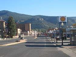 Downtown Raton (2010) | |
 Location within Colfax County and New Mexico | |
| Coordinates: 36°53′49″N 104°26′24″W | |
| Country | United States |
| State | New Mexico |
| County | Colfax |
| Area | |
| • Total | 8.0 sq mi (20.6 km2) |
| • Land | 8.0 sq mi (20.6 km2) |
| • Water | 0.0 sq mi (0.0 km2) |
| Elevation | 6,680 ft (2,036 m) |
| Population (2010) | |
| • Total | 6,885 |
| • Estimate (2018)[1] | 6,035 |
| • Density | 870/sq mi (330/km2) |
| Time zone | UTC−7 (Mountain (MST)) |
| • Summer (DST) | UTC−6 (MDT) |
| ZIP code | 87740 |
| Area code | 575 |
| FIPS code | 35-62060 |
| GNIS feature ID | 0902335 |
| Website | ratonnm |
History
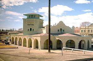
_IMG_4971.JPG)
Ratón is the Spanish word for mouse.
Raton Pass had been used by Spanish explorers and Indians for centuries to cut through the rugged Rocky Mountains, and the mountain branch of the Santa Fe Trail cuts through the city, along what is now Business I-25.
The post office at this location was named Willow Springs from 1877 to 1879, Otero from 1879 to 1880, then renamed Raton in 1880.[3]:286
Raton was founded at the site of Willow Springs, a stop on the Santa Fe Trail. The original 320 acres (129.5 ha) for the Raton townsite were purchased from the Maxwell Land Grant in 1880. In 1879, the Atchison, Topeka and Santa Fe Railway bought a local toll road and established a busy rail line. Raton quickly developed as a railroad, mining and ranching center for the northeast part of the New Mexico territory, as well as the county seat and principal trading center of the area.
The city is mentioned in Jack Kerouac's novel On the Road.
Geography
Raton is located at 36°53′49″N 104°26′24″W (36.897082, -104.439912).[4] According to the United States Census Bureau, the city has a total area of 8.0 square miles (20.6 km2), all land.[5] The Raton Range and Raton Peak are located immediately north of the town. The Raton Range is a 75-mile-long (121 km) ridge that extends east from the Sangre de Cristo Mountains. Raton Pass and the Raton Basin are also named for the Raton Range.
Geology


Raton is one of the famous sites for viewing the K-T Boundary, also known as the K-Pg Boundary or Cretaceous-Paleogene Boundary, or the Iridium Layer.[6] There is a well-preserved sequence of rocks spanning the Cretaceous–Paleogene boundary in Climax Canyon Park, a Raton city park to the west of town.[6][7] Geographic Coordinates: 36°54′13.99″N 104°27′0.75″W
The rocks have been studied for evidence of the iridium anomaly cited as evidence of a large meteorite impact at the end of the Cretaceous.[6][8] It is interpreted to have caused the Cretaceous–Paleogene extinction event which killed off non-avian dinosaurs, as well as many other species of flora and fauna 66 million years ago.[8] The K-T Boundary is represented in the rock strata by a 1-cm thick tonstein clay layer which has been found to contain anomalously high concentrations of iridium.[6][9]
Demographics
| Historical population | |||
|---|---|---|---|
| Census | Pop. | %± | |
| 1890 | 1,255 | — | |
| 1900 | 3,540 | 182.1% | |
| 1910 | 4,539 | 28.2% | |
| 1920 | 5,544 | 22.1% | |
| 1930 | 6,090 | 9.8% | |
| 1940 | 7,607 | 24.9% | |
| 1950 | 8,241 | 8.3% | |
| 1960 | 8,146 | −1.2% | |
| 1970 | 6,962 | −14.5% | |
| 1980 | 8,225 | 18.1% | |
| 1990 | 7,372 | −10.4% | |
| 2000 | 7,282 | −1.2% | |
| 2010 | 6,885 | −5.5% | |
| Est. 2018 | 6,035 | [1] | −12.3% |
| U.S. Decennial Census[10] | |||
As of the United States Census[11] of 2000, there were 7,282 people, 3,035 households, and 1,981 families residing in the city. The population density was 992.4 people per square mile (383.1/km²). There were 3,472 housing units at an average density of 473.2 per square mile (182.6/km²). The racial makeup of the city was 78.04% White, 0.23% African American, 1.59% Native American, 0.40% Asian, 0.01% Pacific Islander, 16.19% from other races, and 3.53% from two or more races. Hispanic or Latino of any race were 56.96% of the population.
There were 3,035 households out of which 30.7% had children under the age of 18 living with them, 47.0% were married couples living together, 12.9% had a female householder with no husband present, and 34.7% were non-families. 30.6% of all households were made up of individuals and 14.1% had someone living alone who was 65 years of age or older. The average household size was 2.35 and the average family size was 2.92.
In the city, the population was spread out with 25.1% under the age of 18, 7.8% from 18 to 24, 24.9% from 25 to 44, 23.9% from 45 to 64, and 18.4% who were 65 years of age or older. The median age was 40 years. For every 100 females, there were 94.5 males. For every 100 females age 18 and over, there were 92.1 males.
The median income for a household in the city was $27,028, and the median income for a family was $31,762. Males had a median income of $24,946 versus $18,433 for females. The per capita income for the city was $14,223. About 14.8% of families and 17.4% of the population were below the poverty line, including 25.2% of those under age 18 and 10.4% of those age 65 or over.
In the United States Census of 2010,[12] the population of Raton had dropped to 6,885, and was estimated to have dropped to 6,066 by July 1, 2018.
Transportation
Rail
- Raton Amtrak Station is a stop on the Southwest Chief route.
Recreation
Sugarite Canyon State Park is located 12 miles (19 km) northeast of Raton at an elevation of 8,800 feet (2,700 m). Activities there include camping, fishing, and hiking.
The NRA Whittington Center is located 15 miles (24 km) southwest of Raton. It is the largest NRA shooting range in the US. It hosts national competitions. High-powered rifle and skeet shooting are possible.
Run to Raton, a motorcycle rally that includes camp outs, vendors, free music, and a pin up contest, takes place every July.
Raton was the site of New Mexico's first horse racetrack, La Mesa Park, which closed in 1992.
Raton is home to the International Balloon Rally, a hot air balloon gathering, held on the Fourth of July weekend.
Notable people
- Tom W. Blackburn, Western writer who also wrote the lyrics to "The Ballad of Davy Crockett"
- Edwin Fullinwider, Olympic fencer
- Noel Mazzone, offensive coordinator for the University of Arizona football team
- Paul L. Modrich received the Nobel Prize in Chemistry in 2015
- John Morrow, United States Representative from New Mexico
- John R. Sinnock, US Mint engraver known for work on the FDR dime
- Petro Vlahos, three-time Academy Award-winning Hollywood special effects pioneer
- Robert W. Warren, Attorney General of Wisconsin
- Bennie L. Woolley, Jr., racehorse trainer who won the 2009 Kentucky Derby
- Notable group
- The Fireballs, rock and roll group who had a #1 hit with 1963's "Sugar Shack" and #9 hit with "Bottle of Wine"
References
- https://www.census.gov/quickfacts/fact/table/ratoncitynewmexico/PST045218
- Cross, Mark H. "Encyclopedia of Santa Fe". Retrieved 2017-05-23.
- Julyan, Robert (1998). The Place Names of New Mexico (Revised ed.). Albuquerque: University of New Mexico Press. ISBN 0-8263-1689-1.
- "US Gazetteer files: 2010, 2000, and 1990". United States Census Bureau. 2011-02-12. Retrieved 2011-04-23.
- "Geographic Identifiers: 2010 Demographic Profile Data (G001): Raton city, New Mexico". U.S. Census Bureau, American Factfinder. Archived from the original on February 12, 2020. Retrieved October 21, 2014.
- Pillmore, C.L.; Fleming, R. Farley (1990). "The Cretaceous-Tertiary Boundary in the Raton Basin, New Mexico and Colorado" (PDF). New Mexico Geological Society Guidebook. 41st Field Conference, Southern Sangre de Cristo Mountains, New Mexico (Southern Sangre de Cristo Mountains): 327–331. Retrieved 5 November 2014.
- Raton, City Manager (2014). Old Raton Pass City Park Map and Brochure (Paper Re-Print ed.). Raton, New Mexico: Raton Visitor Center. pp. 1–2.
- Asimov, Isaac (14 April 1989). "Theory Has Impact on Dinosaur Doom". Los Angeles Times. Retrieved 5 November 2014.
- Renne, Paul R.; Deino, Alan L.; Hilgen, Frederik J.; Kuiper, Klaudia F.; Mark, Darren F.; Mitchell, William S.; Morgan, Leah E.; Mundil, Roland; Smit, Jan (7 February 2013). "Time Scales of Critical Events Around the Cretaceous-Paleogene Boundary" (PDF). Science. 339 (6120): 684–687. Bibcode:2013Sci...339..684R. doi:10.1126/science.1230492. PMID 23393261.
- "Census of Population and Housing". Census.gov. Retrieved June 4, 2015.
- "U.S. Census website". United States Census Bureau. Retrieved 2008-01-31.
- "QuickFacts Raton, New Mexico". United States Census Bureau. Retrieved 2019-01-22.
Further reading
Conway, Jay T. (1930). - A brief community history of Raton, New Mexico, 1880-1930: Commemorating Her Fiftieth Birthday. - Raton, New Mexico: Gazette Print. OCLC 21705239.
External links
| Wikimedia Commons has media related to Raton, New Mexico. |
- City of Raton official website
- Raton Municipal Airport
- Raton Chamber & Economic Development Council

- . Encyclopædia Britannica (11th ed.). 1911.
Municipalities and communities of Colfax County, New Mexico, United States | ||
|---|---|---|
| City | 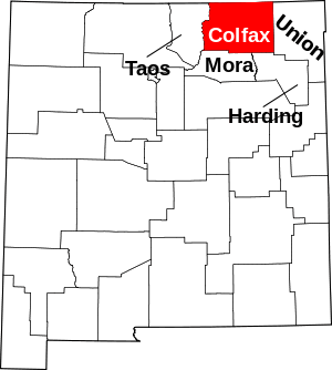 Map of New Mexico highlighting Colfax County | |
| Town | ||
| Villages | ||
| CDP | ||
| Other unincorporated communities | ||
| Ghost towns | ||
Santa Fe (capital) | ||
| Topics |
| |
| Society | ||
| Regions |
| |
| Cities | ||
| Counties | ||

| Authority control |
|
|---|