Los Alamos, New Mexico
Los Alamos (Spanish: Los Álamos, meaning "The Cottonwoods" or "The Poplars")[3] is a town in Los Alamos County, New Mexico, United States, that is recognized as the development and creation place of the atomic bomb—the primary objective of the Manhattan Project by Los Alamos National Laboratory during World War II. The town is located on four mesas of the Pajarito Plateau, and has a population of 12,019.[2] It is the county seat and one of two population centers in the county known as census-designated places (CDPs); the other is White Rock.
Los Alamos, New Mexico | |
|---|---|
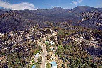
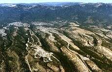 A westward aerial view of Los Alamos | |
| Nickname(s): Atomic City; The Hill; Site Y; Secret City (past) | |
| Motto(s): "Where discoveries are made" | |
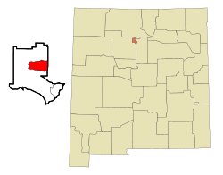 Location of Los Alamos, New Mexico | |
 Los Alamos, New Mexico Location in New Mexico  Los Alamos, New Mexico Location in the contiguous United States | |
| Coordinates: 35°53′28″N 106°17′52″W | |
| Country | |
| State | |
| County | Los Alamos |
| Area | |
| • Total | 11.1 sq mi (28.8 km2) |
| • Land | 11.1 sq mi (28.8 km2) |
| • Water | 0.0 sq mi (0.0 km2) |
| Elevation | 7,320 ft (2,231 m) |
| Population (2010)[2] | |
| • Total | 12,019 |
| • Density | 1,080/sq mi (417.1/km2) |
| Time zone | UTC−7 (Mountain (MST)) |
| • Summer (DST) | UTC−6 (MDT) |
| ZIP codes | 87544, 87547 |
| Area code(s) | 505 |
| FIPS code | 35-42320 |
| GNIS feature ID | 0901357 |
History
The ruins of permanent Puebloan settlements, such as those located in nearby Bandelier National Monument and Tsankawi, and numerous other sites such as cliff dwellings indicate that the area has been inhabited during various eras since around 1150 AD. The first settlers on the plateau are thought to be Keres speaking Native Americans around the 10th century. Around 1300, Tewa settlers immigrated from the Four Corners Region and built large cities but were driven out within 50 years by Navajo and Apache raids and by drought.
In the late 19th century, homesteaders utilized the land for ranching. Most homesteaders built simple log cabins that they only lived in during warm weather to feed livestock. Many of the homesteaders later moved down to the warmer Rio Grande Valley. In 1917, homesteader Harold H. Brook sold part of his land and buildings to Ashley Pond II, a businessman from Detroit who founded the Los Alamos Ranch School. The area was used to teach young men basic ranching and other outdoor survival skills.
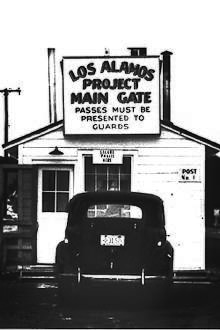
In 1943, during World War II, the United States Department of War exercised eminent domain over the Ranch School and all remaining homesteads in the area so that the relatively isolated location could be used for the secretive Manhattan Project, which ultimately developed the world's first nuclear weapons.[4] Facilities for research and development were quickly built and scientists and engineers from all over the world were assigned to the project, however all information about the town and project was held secretively away from public awareness. Los Alamos was referred to under the code name "Site Y" by military personnel, and was known only as "The Hill" by many in nearby Santa Fe. The specific location of the project and all of its residents was also concealed by designating its mailing address as PO Box 1663, Santa Fe, NM. All incoming truckloads were falsely labeled as common items in order to conceal the true nature of their contents, and any outbound correspondence by those working and living in Los Alamos was censored by military officials. Not until after the bombing of Hiroshima was information about the purpose of the Manhattan Project released to the public.
In the years after World War II, the laboratory was established as a research government facility under the Department of Energy, and is now known as Los Alamos National Laboratory.
Geography
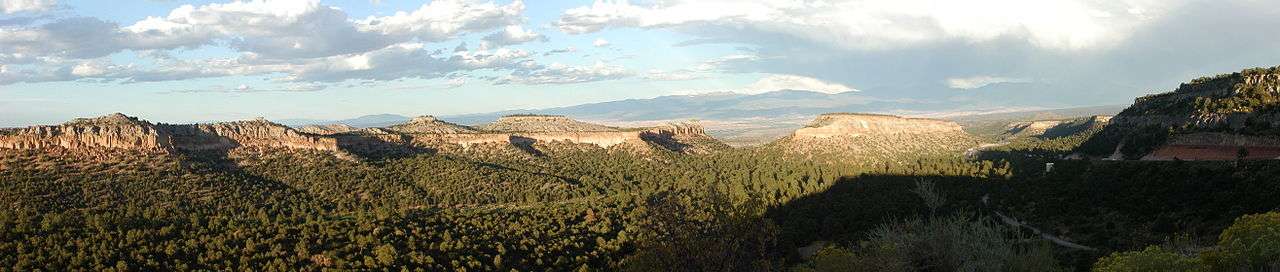
Los Alamos is located in northern New Mexico between the Rio Grande and the eastern rim of the Valles Caldera on the Pajarito Plateau, approximately 35 mi (56 km) to the northwest of Santa Fe. The elevation at the post office is 7,320 feet (2,230 m) and total land area is 11.14 square miles (28.9 km2).
The Los Alamos Townsite and White Rock are located on flat mesa tops separated by steep canyons. This location was chosen for its relative inaccessibility to help protect the secret activities of the Manhattan Project.
The town of Los Alamos was built on four mesas—Barranca Mesa, North Mesa, Los Alamos Mesa and South Mesa—along with the connecting communities at the base of the mountain. Los Alamos National Laboratory occupies half of South Mesa, Two Mile Mesa, Frijoles Mesa, Mesita de Buey and several nearby areas in the region (in the valleys and at the base of the mountain). White Rock lies at the top of White Rock Canyon.
Much of Los Alamos County is within the Española Ranger District of the Santa Fe National Forest.
Climate
Los Alamos has a borderline cool semi-arid climate (Köppen BSk)/humid continental climate (Dfb)[5][6] with four distinct seasons. Summer days are moderately warm in the 70s and 80s, but infrequently reach 90 °F (32.2 °C).[5]
| Climate data for Los Alamos, New Mexico (1942-2006) | |||||||||||||
|---|---|---|---|---|---|---|---|---|---|---|---|---|---|
| Month | Jan | Feb | Mar | Apr | May | Jun | Jul | Aug | Sep | Oct | Nov | Dec | Year |
| Record high °F (°C) | 65 (18) |
69 (21) |
73 (23) |
80 (27) |
92 (33) |
95 (35) |
94 (34) |
91 (33) |
90 (32) |
84 (29) |
72 (22) |
64 (18) |
95 (35) |
| Average high °F (°C) | 40 (4) |
43 (6) |
50 (10) |
59 (15) |
68 (20) |
78 (26) |
81 (27) |
78 (26) |
73 (23) |
62 (17) |
49 (9) |
41 (5) |
60 (16) |
| Daily mean °F (°C) | 29 (−2) |
33 (1) |
38 (3) |
46 (8) |
56 (13) |
65 (18) |
68 (20) |
66 (19) |
60 (16) |
50 (10) |
38 (3) |
30 (−1) |
48 (9) |
| Average low °F (°C) | 19 (−7) |
22 (−6) |
27 (−3) |
34 (1) |
43 (6) |
52 (11) |
56 (13) |
54 (12) |
48 (9) |
38 (3) |
27 (−3) |
20 (−7) |
37 (3) |
| Record low °F (°C) | −18 (−28) |
−17 (−27) |
−3 (−19) |
8 (−13) |
24 (−4) |
32 (0) |
40 (4) |
31 (−1) |
25 (−4) |
6 (−14) |
−14 (−26) |
−13 (−25) |
−18 (−28) |
| Average precipitation inches (mm) | 0.9 (23) |
0.8 (20) |
1.1 (28) |
1.0 (25) |
1.2 (30) |
1.3 (33) |
3.0 (76) |
3.7 (94) |
1.8 (46) |
1.5 (38) |
0.9 (23) |
0.9 (23) |
18.1 (460) |
| Average snowfall inches (cm) | 12.0 (30) |
9.3 (24) |
10 (25) |
4.5 (11) |
0.6 (1.5) |
0.0 (0.0) |
0.0 (0.0) |
0.0 (0.0) |
0.0 (0.0) |
2.0 (5.1) |
5.0 (13) |
10.6 (27) |
54.0 (137) |
| Average precipitation days | 5 | 6 | 7 | 6 | 7 | 7 | 13 | 15 | 8 | 6 | 5 | 5 | 90 |
| Source 1: Western Regional Climate Center - Temperature [7] | |||||||||||||
| Source 2: Western Regional Climate Center - Precipitation [8] | |||||||||||||
Wildlife and vegetation
Los Alamos' geographical location causes its wildlife and vegetation to be diverse compared to surrounding areas in the state. "The variation in elevation creates precipitation and temperature gradients that support a wide diversity of plant communities..."[9] There are six different plant communities within the county; each is home to unique flora and fauna.[9] Ponderosa pine trees are the most common trees at the elevation of Los Alamos (7,000 and 8,000 feet (2,100 and 2,400 m)). Common shrubs in the area include sagebrush, Gambel oak, and wild rose.[9]
Black bears (brown-color variation), elk, mule deer, bobcats, gray foxes, skunks and chipmunks are examples of mammals living in the area.[10] "Over 200 species of birds have been reported" in the Pajarito Ornithological Survey conducted by LANL.[11] Among these are broad-tailed hummingbirds, hairy woodpeckers, zone-tailed hawks, common ravens, western bluebirds, and great horned owls.[11]
Wildfires
Wildfires have affected the county, but the most destructive to the townsite was the Cerro Grande Fire of May 2000, which caused an estimated $1 billion in damages and destroyed more than 400 homes. The town was evacuated for eight days. The Federal Emergency Management Agency (FEMA) built temporary housing on North Mesa for those who were displaced by the fire. Though there was no loss of life, other effects include damage to LANL facilities (nuclear material was not affected), flash-flooding, and erosion.
The Las Conchas Fire of June 26, 2011[12] burned about three times as many acres and also prompted evacuation of Los Alamos, but there was no damage to property in Los Alamos.[13]It was the biggest wildfire New Mexico had endured.[12]
| Wildfire (year) | Burned area | Cause |
|---|---|---|
| Water Canyon Fire (1954) | 3,000 acres (10 km2)[14] | trash/construction debris fire[14] |
| La Mesa Fire (1977) | 15,400 acres (60 km2)[14] | human-caused[14] |
| Dome Fire (1996) | 16,500 acres (65 km2) | abandoned campfire[15] |
| Oso Complex Fire (1998) | 5,200 acres (20 km2) | arson |
| Cerro Grande Fire (2000) | 48,000 acres (195 km2)[16] | controlled burn |
| Las Conchas Fire (2011) | 156,800 acres (635 km2)[17] | Power line[18] |
Wildfires have altered plant communities in the area. Plant species are migrating to cover burn areas.
Environmental remediation
Over two thousand sites in the area have been determined to have been impacted as a result of past activities at LANL. The location of these sites have been identified throughout the county, and are primarily (but not exclusively) on DOE property. Contaminated sites vary widely in significance. Corrective action and environmental restoration has been deemed necessary for certain areas; LANL takes part in this process.[19] Some residents have voiced concern about a lack of public participation and opportunity to comment on the clean-up schedule and funding.[20]
Demographics
The current population is 12,019 with a population density of 1,078.7 inhabitants per square mile (416.5/km2).[21] The median age is 40 years. 24.8% of the people are under the age of 18, 4.8% are ages 18 to 24, 29.2% are ages 25 to 44, 28.2% are ages 45 to 64, and 12.9% are ages 65 years or older. For every 100 females, there were 101.3 males.[22]
| Historical population | ||
|---|---|---|
| Year | Pop. | ±% |
| 1970 | 11,310 | — |
| 1980 | 11,039 | −2.4% |
| 1990 | 11,455 | +3.8% |
| 2000 | 11,909 | +4.0% |
| 2010 | 12,019 | +0.9% |
| 2015 | 11,814 | −1.7% |
Race
| Racial composition | 2010[21] |
|---|---|
| White | 85.9% |
| —Non-Hispanic | 74.8% |
| Hispanic or Latino (of any race) | 14.3% |
| Asian | 7.2% |
| American Indian and Alaska Native | 0.8% |
| Black or African American | 0.6% |
Los Alamos is demographically unique compared to its surrounding counties and the state as a whole. Over 35% of the population of surrounding counties (Rio Arriba, Santa Fe, and Sandoval) and the state of New Mexico are Hispanic or Latino, while only about 15% of Los Alamosans are Hispanic or Latino. The white and especially the Asian populations of Los Alamos are significantly higher than the rest of New Mexico.[21]
Culture
Notable people

- Hans Bethe, nuclear physicist, awarded 1967 Nobel Prize in Physics
- Richard Feynman, theoretical physicist, awarded 1965 Nobel Prize in Physics, shared with Sin-Itiro Tomonaga and Julian Schwinger[23]
- Kolinda Grabar-Kitarović, current president of Croatia; graduated from Los Alamos High School in 1986
- Michelle Lujan Grisham, current governor of New Mexico and former U.S. congresswoman
- Kevin R. Johnson, chief executive officer (CEO) of Starbucks Coffee Company; graduated from Los Alamos High School in 1978
- J. Robert Oppenheimer, theoretical physicist
- Frederick Reines, theoretical physicist, awarded 1995 Nobel Prize in Physics
Sports and recreation
The geography of Los Alamos lends itself to several sports and recreational activities. Skiing is possible on 10,440 ft. Pajarito Mountain between November and April. Snowshoeing is possible at Valles Caldera National Preserve and other locations weather permitting. On November 10, 2015, the National Park Service and the U.S. Department of Energy announced the establishment of Manhattan Project National Historical Park in Los Alamos, along with units in Hanford, Washington and Oak Ridge, Tennessee.
Los Alamos is host to several sporting events:
- Tour de Los Alamos (road cycling race)
- Run the Caldera Marathon
- Pajarito Punishment (mountain-biking race)
- Los Alamos Triathlon (Los Alamos Junior Triathlon)
- Jemez Mountain Trail Run
Economy
Los Alamos is the fifth-fastest-growing city in New Mexico, after Albuquerque, Rio Rancho, Las Cruces, and Ruidoso.
Income and poverty
The median household income in Los Alamos is $98,458, and per capita income is $54,067. Income is significantly higher than the rest of New Mexico.[21] Los Alamos has the highest millionaire concentration of any US city, with 12.4 percent of households having at least $1 million in assets.[24] This is a result of chemists, engineers, and physicists working at LANL since the Manhattan Project.[25] Only 6.6% of people are below the poverty line; half the rate of the United States, and one-third the rate of New Mexico.[21] As of January 2015, there were zero homeless individuals.[26]
Families and housing
There are 5,249 households and an average household size of 2.23 people. There are 5,863 housing units, and the median value of owner-occupied housing units is $281,500. Median gross rent is $921.[21]
31.4% of households have children under the age of 18 living with them, 56.4% are married couples living together, 6.5% have a female householder with no husband present, and 34.0% are non-families. 29.8% of all households are made up of individuals and 7.6% have someone living alone who is 65 years of age or older.
Principal employers
Los Alamos National Laboratory is the area's largest employer with approximately 10,500 employees, and is foundational to the economy of Los Alamos, with an annual budget of about $2.45 billion. Approximately 40% of the laboratory's employees live in Los Alamos, while the remainder commute from Santa Fe, Española, Taos, and Albuquerque. About 66% of the people who work in the national laboratories commute daily to the lab; some take the Atomic City Transit, Rail Runner Express, use the Park and Ride, or carpool with other employees.[27]
Other major employers in Los Alamos include Smith's Food and Drug, Los Alamos National Bank, Los Alamos Medical Center, National Security Technologies, Los Alamos County, Los Alamos Public Schools, and Del Norte Credit Union.[28]
Transportation
Los Alamos provides several transportation services:[29][30]
Roads
Los Alamos is relatively isolated, and can only be accessed from NM 4 from the south and NM 502 from the east.
NM 502 sees significantly more traffic because it connects with US 84/285, which delivers access to several Pueblo communities between Española and Santa Fe. Approximately 10,000 commuters use NM 502 daily. NM 502 begins at Pojoaque, and traverses San Ildefonso Pueblo and the Rio Grande.
Interstate 25 is the nearest major interstate highway, and passes through or near Santa Fe, Albuquerque and Denver.
There are three access roads between White Rock and Los Alamos—Main Hill Road, Jemez Road and Pajarito Road. Since the attacks of September 11, 2001, Pajarito Road has been restricted to LANL badge holders for security reasons.
Transit systems
- Atomic City Transit
- New Mexico Department of Transportation (NMDOT) Park-and-Ride
- New Mexico Rail Runner Express
Air
Los Alamos County Airport, located on the eastern edge of Los Alamos, is the only airport in the county. The main source of activity is from small private aircraft, with intermittent commercial commuter service.
Health care
The 47-bed acute-care facility known as Los Alamos Medical Center is the only hospital in Los Alamos and is a LifePoint Health hospital. The hospital provides "complete medical, surgical, obstetrical, pediatric, emergency, and diagnostic services"[31] and employs about 300 Northern New Mexicans.[32]
Medical Associates of Northern New Mexico (MANNM) is a group of medical providers that offers family medicine, internal medicine, cardiology, nephrology, and endocrinology among its many services.[33]
During the Cold War, workers at LANL were in contact with radiation and other toxins, causing many of these individuals illness. A non-profit organization called Cold War Patriots provides these individuals and their families with information about the healthcare benefits available to them.[34]
VLBA node
The radio telescope located in Los Alamos is one of ten dishes composing the Very Long Baseline Array (VLBA).
City and regional partnerships
Coworking
In June 2016 a collaboration was initiated between the County of Los Alamos, the Los Alamos Commerce & Development Corporation and the Los Alamos National Laboratory's Feynman Center for Innovation and Community Relations and Partnerships Office, to open a private, non-profit coworking space called ProjectY cowork Los Alamos,[35] which helped create educational programs for the two cities to learn more about each other's culture and communities.[36]
See also
- Bandelier National Monument, National Park Service unit
- Bradbury Science Museum
- Casa Mesita
- Ed Grothus
- Manhattan Project National Historical Park, National Park Service and Department of Energy unit
- Oak Ridge, Tennessee
References
- "U.S. Gazetteer Files: 2019: Places: New Mexico". U.S. Census Bureau Geography Division. Retrieved May 18, 2020.
- "Total Population: 2010 Census DEC Summary File 1 (P1), Los Alamos CDP, New Mexico". data.census.gov. U.S. Census Bureau. Retrieved May 18, 2020.
- Julyan, Robert Hixson (1998), The Place Names of New Mexico, Albuquerque: University of New Mexico Press, p. 208, ISBN 978-08263-1689-9
- https://www.lanl.gov/about/history-innovation/
- Bowen, Brent M. (May 1990). Los Alamos Climatology. Los Alamos: Los Alamos National Laboratory. pp. 3–5.
- Environmental Surveillance at Los Alamos during 2008. Los Alamos National Laboratory. September 2009. p. 32.
- "Period of Record General Climate Summary - Temperature". WRCC. Retrieved January 5, 2017.
- "Period of Record General Climate Summary - Precipitation". WRCC. Retrieved January 5, 2017.
- Foxx, Teralene; Craig, Martin; Dorothy, Noonan (2016). Plants of the Jemez Mountains, Volume 1. Los Alamos, NM: All Seasons Publishing. pp. 1–3. ISBN 978-0-963-90407-2.
- Findley, James S.; Arthur H., Harris; Don E., Wilson; Clyde, Jones (1975). Mammals of New Mexico. Albuquerque: University of New Mexico Press. pp. 289, 293, 319, 327. ISBN 0-8263-0369-2.
- Travis, James R. (October 1992). Atlas of the Breeding Birds of Los alamos County, New Mexico. Los Alamos: Los Alamos National Laboratory. pp. 2–3, 14, 51, 71, 87, 101, 145, 177.
- "Wildfires may contribute more to global warming than previously predicted | EarthSky.org". earthsky.org. Retrieved 2019-05-06.
- "Las Conchas Wildfire". Incident Information System. Archived from the original on 9 July 2011. Retrieved 6 July 2011.
- "Fuels Inventories in the Los Alamos National Laboratory". Los Alamos National Laboratory. March 1999. Retrieved January 10, 2016.
- Associated Press (April 29, 1996). "N.M. fire threatens Indian sites". Lawrence Journal-World. Retrieved January 10, 2016.
- "Lessons Learned From the Cerro Grande (Los Alamos) Fire" (PDF). United States General Accounting Office Testimony. US Government Accountability Office. Retrieved January 10, 2017.
- "Las Conchas Wildfire". Incident Information System. Retrieved August 14, 2011.
- "Investigators determine cause of Las Conchas Fire". New Mexico Fire Information. July 3, 2011. Archived from the original on July 15, 2011. Retrieved July 5, 2011.
- "Environmental Stewardship". LANL.gov. Los Alamos National Security for US Department of Energy. Retrieved 13 January 2018.
- o'neil, marie (3 January 2018). "doe/nmed host meeting on legacy waste clean-up". los alamos daily post.
- "Los Alamos CDP, New Mexico". State & County QuickFacts. U.S. Census Bureau.
- FlexKit. "Commercial & Residential Pressure Washing Services in Los Alamos, New Mexico | A Clean Slate". www.acleanslatenm.com. Retrieved 2019-05-06.
- "The Nobel Prize in Physics 1965". www.nobelprize.org.
- "Los Alamos ranked highest in wealthy households | LAMonitor.com". www.lamonitor.com. Retrieved 2019-04-18.
- Burney, Teresa (December 7, 2011). "Jobs Gained, Jobs Lost, and Millionaire-Making Jobs". Builder. 34 (12): 16.
- http://www.nmceh.org/pages/reports/2015%20Point%20In%20Time%20by%20County.pdf
- Energy, Los Alamos National Laboratory, Operated by Los Alamos National Security, LLC, for the U. S. Department of. "Transportation for Lab Employees". www.lanl.gov. Retrieved 2019-05-06.
- Search Results - Los Alamos, New Mexico - ReferenceUSA Current Businesses
- http://www.losalamosnm.us/transit/Documents/Los%20Alamos%20Transit%20Study_FINAL.pdf
- http://www.losalamoscountycompplan2016.com/documents/pdfs/white_papers/transportation_v4.pdf
- "About Us - Los Alamos Medical Center". www.losalamosmedicalcenter.com.
- "About Us | Los Alamos Medical Center". www.losalamosmedicalcenter.com. Retrieved 2019-05-06.
- "Services - Medical Associates of Northern New Mexico - Cardiology". www.mannm.com.
- https://www.coldwarpatriots.org/about/
- Writer, T. S. Last | Journal Staff. "Updated: Coworking spaces blooming in Los Alamos, elsewhere". www.abqjournal.com. Retrieved 2016-10-14.
- "Los Alamos - Sarov Sister Cities - Home". www.lasarov.org. Retrieved 2019-05-06.
External links
| Wikimedia Commons has media related to Los Alamos, New Mexico. |
| Wikivoyage has a travel guide for Los Alamos. |
- Los Alamos County website
- Los Alamos Chamber of Commerce
- Los Alamos Historical Society
- Bandelier National Monument
- h2g2 article on Los Alamos, New Mexico
- Los Alamos-Sarov Sister Cities website
- Los Alamos, NM at Curlie
Municipalities and communities of Los Alamos County, New Mexico, United States | ||
|---|---|---|
| CDPs |  Map of New Mexico highlighting Los Alamos County | |
Santa Fe (capital) | ||
| Topics |
| |
| Society | ||
| Regions |
| |
| Cities | ||
| Counties | ||

| Authority control |
|
|---|