Albuquerque, New Mexico
Albuquerque (/ˈælbəkɜːrki/ (![]()
![]()
Albuquerque, New Mexico | |
|---|---|
City | |
| City of Albuquerque | |
 | |
Seal | |
| Nicknames: ABQ, Burque, The 505, The Duke City, The Q | |
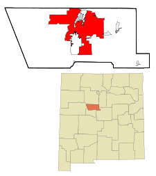 Location within Bernalillo County | |
 Albuquerque Location within New Mexico  Albuquerque Location within the United States | |
| Coordinates: 35°06′39″N 106°36′36″W | |
| Country | United States |
| State | New Mexico |
| County | Bernalillo |
| Founded | 1706 (as Alburquerque) |
| Incorporated | 1891 (as Albuquerque) |
| Named for | Francisco Fernández de la Cueva, Duke of Alburquerque |
| Government | |
| • Type | Mayor-council government |
| • Mayor | Tim Keller (D) |
| • City Council | Councilors
|
| • State House | Representatives
|
| • State Senate | State senators
|
| • U.S. House | Deb Haaland (D) Xochitl Torres Small (D) |
| Area | |
| • City | 189.5 sq mi (490.9 km2) |
| • Land | 187.7 sq mi (486.2 km2) |
| • Water | 1.8 sq mi (4.7 km2) |
| Elevation | 5,312 ft (1,619.1 m) |
| Population | |
| • City | 545,852 |
| • Estimate (2019)[2] | 560,513 |
| • Rank | US: 32nd |
| • Density | 2,900/sq mi (1,100/km2) |
| • Metro | 915,927 (60th) 1,171,991 (Albuquerque–Santa Fe–Las Vegas CSA) |
| Demonyms | Albuquerquean, Burqueño[3] |
| Time zone | UTC−7 (MST) |
| • Summer (DST) | UTC−6 (MDT) |
| ZIP Codes | 87101–87125, 87131, 87151, 87153, 87154, 87158, 87174, 87176, 87181, 87184, 87185, 87187, 87190–87199 |
| Area codes | 505, 575 |
| FIPS code | 35-02000 |
| GNIS feature ID | 928679 |
| Primary Airport | Albuquerque International Sunport ABQ (Major/International) |
| Secondary Airport | Double Eagle II Airport- KAEG (Public) |
| Website | cabq |
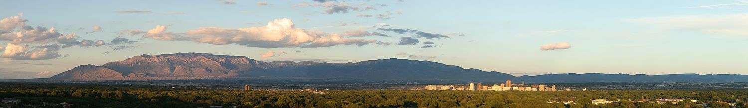
Albuquerque serves as the county seat of Bernalillo County,[8] and is in north-central New Mexico. The Sandia Mountains run along the eastern side of Albuquerque, and the Rio Grande flows north to south through its center, while the West Mesa and Petroglyph National Monument make up the western part of the city. Albuquerque has one of the highest elevations of any major city in the U.S., ranging from 4,900 feet (1,490 m) above sea level near the Rio Grande to over 6,700 feet (1,950 m) in the foothill areas of Sandia Heights and Glenwood Hills. The civic apex is found in an undeveloped area within the Albuquerque Open Space; there, the terrain rises to an elevation of approximately 6880+ feet (2,097 m).
The economy of Albuquerque centers on science, medicine, technology, commerce, education, entertainment, and culture outlets. The city is home to Kirtland Air Force Base, Sandia National Laboratories, Lovelace Respiratory Research Institute, Presbyterian Health Services, and both the University of New Mexico and Central New Mexico Community College have their main campuses in the city. Albuquerque is the center of the New Mexico Technology Corridor, a concentration of high-tech institutions, including the metropolitan area being the location of Intel's Fab 11X In Rio Rancho and a Facebook Data Center in Los Lunas, Albuquerque was also the founding location of MITS and Microsoft. Film studios have a major presence in the state of New Mexico, for example Netflix has a main production hub at Albuquerque Studios. There are numerous shopping centers and malls within the city, including ABQ Uptown, Coronado, Cottonwood, Nob Hill, and Winrock. The city is the location of a horse racing track and casino called The Downs Casino and Racetrack, and the Pueblos surrounding the city feature resort casinos, including Sandia Resort, Santa Ana Star, Isleta Resort, and Laguna Pueblo's Route 66 Resort.
The city hosts the International Balloon Fiesta, the world's largest gathering of hot-air balloons, taking place every October at a venue referred to as Balloon Fiesta Park, with its 47-acre launch field.[9] Another large venue is Expo New Mexico where other annual events are held, such as North America's largest pow wow at the Gathering of Nations, as well as the New Mexico State Fair. While other major venues throughout the metropolitan area include the National Hispanic Cultural Center, the University of New Mexico's Popejoy Hall, Santa Ana Star Center, and Isleta Amphitheater. Old Town Albuquerque's Plaza, Hotel, and San Felipe de Neri Church hosts traditional fiestas and events such as weddings, also near Old Town are the New Mexico Museum of Natural History and Science, Albuquerque Museum of Art and History, Indian Pueblo Cultural Center, Explora, and Albuquerque Biological Park. Located in Downtown Albuquerque are historic theaters such as the KiMo Theater, and near the Civic Plaza is the Al Hurricane Pavilion and Albuquerque Convention Center with its Kiva Auditorium. Due to its population size, the metropolitan area regularly receives most national and international music concerts, Broadway shows, and other large traveling events, as well as New Mexico music, and other local music performances.
Likewise, due to the metropolitan size, it is home to a diverse restaurant scene from various global cuisines, and the state's distinct New Mexican cuisine. Being the focus of the Middle Rio Grande Conservancy District gives an agricultural contrast, along acequias, to the otherwise heavily urban setting of the city. Crops such as New Mexico chile are grown along the entire Rio Grande, the red or green chile pepper is a staple of the aforementioned New Mexican cuisine. The Albuquerque metro is a major contributor of the Middle Rio Grande Valley AVA with New Mexico wine produced at several vineyards, it is also home to several New Mexican breweries. The river also provides trade access with the Mesilla Valley (containing Las Cruces, New Mexico and El Paso, Texas) region to the south, with its Mesilla Valley AVA and the adjacent Hatch Valley which is well known for its New Mexico chile peppers.
History
Petroglyphs carved into basalt in the western part of the city bear testimony to an early Native American presence in the area, now preserved in the Petroglyph National Monument.
The Tanoan and Keresan peoples had lived along the Rio Grande for centuries before European settlers arrived in what is now Albuquerque. By the 1500s, there were around 20 Tiwa pueblos along a 60-mile (97 km) stretch of river from present-day Algodones to the Rio Puerco confluence south of Belen. Of these, 12 or 13 were densely clustered near present-day Bernalillo and the remainder were spread out to the south.[10]
Two Tiwa pueblos lie specifically on the outskirts of the present-day city, both of which have been continuously inhabited for many centuries: Sandia Pueblo, which was founded in the 14th century,[11] and the Pueblo of Isleta, for which written records go back to the early 17th century, when it was chosen as the site of the San Agustín de la Isleta Mission, a Catholic mission.
The Navajo, Apache, and Comanche peoples were also likely to have set camps in the Albuquerque area, as there is evidence of trade and cultural exchange between the different Native American groups going back centuries before European arrival.[12]
Albuquerque was founded in 1706 as an outpost as La Villa de Alburquerque in the provincial kingdom of Santa Fe de Nuevo Mexico.[13] Albuquerque was a farming and shepherding community and strategically located trading and military outpost along the Camino Real, for the other already established Pueblo and Hispano communities in the area.[14]
After 1821, Mexico also had a military presence there. The town of Alburquerque was built in the traditional Spanish villa pattern: a central plaza surrounded by government buildings, homes, and a church. This central plaza area has been preserved and is open to the public as a cultural area and center of commerce. It is referred to as "Old Town Albuquerque" or simply "Old Town". Historically it was sometimes referred to as "La Placita" (Little Plaza in Spanish). On the north side of Old Town Plaza is San Felipe de Neri Church. Built in 1793, it is one of the oldest surviving buildings in the city.[15]
After the New Mexico Territory became a part of the United States, Albuquerque had a federal garrison and quartermaster depot, the Post of Albuquerque, from 1846 to 1867. During the Civil War, Albuquerque was occupied in February 1862 by Confederate troops under General Henry Hopkins Sibley, who soon afterward advanced with his main body into northern New Mexico. During his retreat from Union troops into Texas he made a stand on April 8, 1862, at Albuquerque and fought the Battle of Albuquerque against a detachment of Union soldiers commanded by Colonel Edward R. S. Canby. This daylong engagement at long range led to few casualties.
.jpg)
When the Atchison, Topeka and Santa Fe Railroad arrived in 1880, it bypassed the Plaza, locating the passenger depot and railyards about 2 miles (3 km) east in what quickly became known as New Albuquerque or New Town. The railway company built a hospital for its workers that was later a juvenile psychiatric facility and has now been converted to a hotel.[16] Many Anglo merchants, mountain men, and settlers slowly filtered into Albuquerque creating a major mercantile commercial center which is now Downtown Albuquerque. Due to a rising rate of violent crime, gunman Milt Yarberry was appointed the town's first marshal that year. New Albuquerque was incorporated as a town in 1885, with Henry N. Jaffa its first mayor. It was incorporated as a city in 1891.[17]:232–233 Old Town remained a separate community until the 1920s when it was absorbed by Albuquerque. Old Albuquerque High School, the city's first public high school, was established in 1879. Congregation Albert, a Reform synagogue established in 1897, is the oldest continuing Jewish organization in the city.[18]

By 1900, Albuquerque boasted a population of 8,000 inhabitants and all the modern amenities, including an electric street railway connecting Old Town, New Town, and the recently established University of New Mexico campus on the East Mesa. In 1902, the famous Alvarado Hotel was built adjacent to the new passenger depot, and it remained a symbol of the city until it was razed in 1970 to make room for a parking lot. In 2002, the Alvarado Transportation Center was built on the site in a manner resembling the old landmark. The large metro station functions as the downtown headquarters for the city's transit department. It also serves as an intermodal hub for local buses, Greyhound buses, Amtrak passenger trains, and the Rail Runner commuter rail line.
New Mexico's dry climate brought many tuberculosis patients to the city in search of a cure during the early 20th century, and several sanitaria sprang up on the West Mesa to serve them. Presbyterian Hospital and St. Joseph Hospital, two of the largest hospitals in the Southwest, had their beginnings during this period. Influential New Deal–era governor Clyde Tingley and famed Southwestern architect John Gaw Meem were among those brought to New Mexico by tuberculosis.

The first travelers on Route 66 appeared in Albuquerque in 1926, and before long, dozens of motels, restaurants, and gift shops had sprung up along the roadside to serve them. Route 66 originally ran through the city on a north–south alignment along Fourth Street, but in 1937 it was realigned along Central Avenue, a more direct east–west route. The intersection of Fourth and Central downtown was the principal crossroads of the city for decades. The majority of the surviving structures from the Route 66 era are on Central, though there are also some on Fourth. Signs between Bernalillo and Los Lunas along the old route now have brown, historical highway markers denoting it as Pre-1937 Route 66.
The establishment of Kirtland Air Force Base in 1939, Sandia Base in the early 1940s, and Sandia National Laboratories in 1949, would make Albuquerque a key player of the Atomic Age. Meanwhile, the city continued to expand outward into the Northeast Heights, reaching a population of 201,189 by 1960. In 1990, it was 384,736 and in 2007 it was 518,271. In June 2007, Albuquerque was listed as the sixth fastest-growing city in the United States.[19] In 1990, the U.S. Census Bureau reported Albuquerque's population as 34.5% Hispanic and 58.3% non-Hispanic white.[20]
On April 11, 1950, a USAF B-29 bomber carrying a nuclear weapon crashed into a mountain near Manzano Base.[21] On May 22, 1957, a B-36 accidentally dropped a Mark 17 nuclear bomb 4.5 miles from the control tower while landing at Kirtland Air Force Base. Only the conventional trigger detonated, the bomb being unarmed. These incidents were classified for decades.[22]
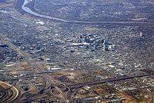
Albuquerque's downtown entered the same phase and development (decline, "urban renewal" with continued decline, and gentrification) as nearly every city across the United States. As Albuquerque spread outward, the downtown area fell into a decline. Many historic buildings were razed in the 1960s and 1970s to make way for new plazas, high-rises, and parking lots as part of the city's urban renewal phase. As of 2010, only recently has Downtown Albuquerque come to regain much of its urban character, mainly through the construction of many new loft apartment buildings and the renovation of historic structures such as the KiMo Theater, in the gentrification phase.
During the 21st century, the Albuquerque population has continued to grow rapidly. The population of the city proper was estimated at 528,497 in 2009, up from 448,607 in the 2000 census.[23] During 2005 and 2006, the city celebrated its tricentennial with a diverse program of cultural events.
The passage of the Planned Growth Strategy in 2002–2004 was the community's strongest effort to create a framework for a more balanced and sustainable approach to urban growth.[24]
Urban sprawl is limited on three sides—by the Sandia Pueblo to the north, the Isleta Pueblo and Kirtland Air Force Base to the south, and the Sandia Mountains to the east. Suburban growth continues at a strong pace to the west, beyond the Petroglyph National Monument, once thought to be a natural boundary to sprawl development.[25]
Because of less-costly land and lower taxes, much of the growth in the metropolitan area is taking place outside of the city of Albuquerque itself. In Rio Rancho to the northwest, the communities east of the mountains, and the incorporated parts of Valencia County, population growth rates approach twice that of Albuquerque. The primary cities in Valencia County are Los Lunas and Belen, both of which are home to growing industrial complexes and new residential subdivisions. The mountain towns of Tijeras, Edgewood, and Moriarty, while close enough to Albuquerque to be considered suburbs, have experienced much less growth compared to Rio Rancho, Bernalillo, Los Lunas, and Belen. Limited water supply and rugged terrain are the main limiting factors for development in these towns. The Mid Region Council of Governments (MRCOG), which includes constituents from throughout the Albuquerque area, was formed to ensure that these governments along the middle Rio Grande would be able to meet the needs of their rapidly rising populations. MRCOG's cornerstone project is currently the New Mexico Rail Runner Express. In October 2013, the Albuquerque Journal reported Albuquerque as the third best city to own an investment property.[26]
Geography
According to the United States Census Bureau, Albuquerque has a total area of 189.5 square miles (490.9 km2), of which 187.7 square miles (486.2 km2) is land and 1.8 square miles (4.7 km2), or 0.96%, is water.[27]
Albuquerque lies within the center of the Albuquerque Basin ecoregion, centered on the Rio Grande with its Bosque gallery forest, flanked easterly by the Sandia–Manzano Mountains and westerly by the West Mesa.[28][29] Located in central New Mexico, the city also has noticeable influences from the adjacent Colorado Plateau semi-desert, New Mexico Mountains forested with juniper and pine, and Southwest plateaus and plains steppe ecoregions, depending on where one is located.
Landforms and drainage
Albuquerque has one of the highest elevations of any major city in the United States, though the effects of this are greatly tempered by its southwesterly continental position. The elevation of the city ranges from 4,900 feet (1,490 m) above sea level near the Rio Grande (in the Valley) to over 6,700 feet (1,950 m) in the foothill areas of Sandia Heights and Glenwood Hills. At the airport, the elevation is 5,352 feet (1,631 m) above sea level.
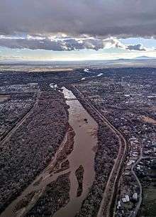
The Rio Grande is classified, like the Nile, as an "exotic" river. The New Mexico portion of the Rio Grande lies within the Rio Grande Rift Valley, bordered by a system of faults, including those that lifted up the adjacent Sandia and Manzano Mountains, while lowering the area where the life-sustaining Rio Grande now flows.
Geology
Albuquerque lies in the Albuquerque Basin, a portion of the Rio Grande rift.[30] The Sandia Mountains are the predominant geographic feature visible in Albuquerque. Sandía is Spanish for "watermelon", and is popularly believed to be a reference to the brilliant coloration of the mountains at sunset: bright pink (melon meat) and green (melon rind). The pink is due to large exposures of granodiorite cliffs, and the green is due to large swaths of conifer forests. However, Robert Julyan notes in The Place Names of New Mexico, "the most likely explanation is the one believed by the Sandia Pueblo Indians: the Spaniards, when they encountered the Pueblo in 1540, called it Sandia, because they thought the squash growing there were watermelons, and the name Sandia soon was transferred to the mountains east of the pueblo."[31] He also notes that the Sandia Pueblo Indians call the mountain Bien Mur, "big mountain."[31]
The Sandia foothills, on the west side of the mountains, have soils derived from that same rock material with varying sizes of decomposed granite, mixed with areas of clay and caliche (a calcium carbonate deposit common in the arid southwestern USA), along with some exposed granite bedrock.
Below the foothills, the area usually called the "Northeast Heights" consists of a mix of clay and caliche soils, overlaying a layer of decomposed granite, resulting from long-term outwash of that material from the adjacent mountains. This bajada is quite noticeable when driving into Albuquerque from the north or south, due to its fairly uniform slope from the mountains' edge downhill to the valley. Sand hills are scattered along the I-25 corridor and directly above the Rio Grande Valley, forming the lower end of the Heights.
The Rio Grande Valley, due to long-term shifting of the actual river channel, contains layers and areas of soils varying between caliche, clay, loam, and even some sand. It is the only part of Albuquerque where the water table often lies close to the surface, sometimes less than 10 feet (3.0 m).
The last significant area of Albuquerque geologically is the West Mesa: this is the elevated land west of the Rio Grande, including "West Bluff", the sandy terrace immediately west and above the river, and the rather sharply defined volcanic escarpment above and west of most of the developed city. The west mesa commonly has soils often referred to as "blow sand", along with occasional clay and caliche and even basalt, nearing the escarpment.
Potential and former native flora
Flora or vegetation surrounding the built portions of the city are typical of their desert southwestern and interior west setting, within the varied elevations and terrain. The limits are by significant urbanization, including much infill development occurring in the last quarter of the twentieth century.
Sandy soils include scrub and mesa vegetation such as sand sagebrush (Artemisia filifolia), fourwing saltbush (Atriplex canescens). Some similar grass and seasonal wildflower species occur that also occur in areas east of the Rio Grande, but in much lower densities. Sparsely as well, sandy soil grasses occur such as Indian ricegrass (Oryzopsis hymenoides), sand dropseed (Sporobolus cryptandrus), and mesa dropseed (Sporobolus flexuosus). Arroyos contain desert willow (Chilopsis linearis) while breaks and the prominent volcanic escarpment include threeleaf sumac with less frequent stands of oneseed juniper (Juniperus monosperma), netleaf hackberry (Celtis reticulata), mariola (Parthenium incanum), and beebrush or oreganillo (Aloysia wrightii). Isolated littleleaf sumac (Rhus microphylla) occurs on the hillsides above Taylor Ranch and at the Petroglyph National Monument Visitor's Center.[32]
Other areas of Albuquerque have more fine clay and caliche soils, plus more rainfall and slightly cooler temperatures, so natural vegetation is dominated by grassland species such as fluffgrass (Erioneuron pulchellum), purple threeawn (Hilaria mutica or Pleuraphis mutica), bush muhly (Muhlenbergia porteri), and black grama (Bouteloua eriopoda). Some woody plants occur in overall grassy areas, mainly fourwing saltbush (Atriplex canescens) and snakeweed (Gutierrezia microcephala). Isolated stands of creosote bush (Larrea tridentata) were reported by long-time residents on gravelly, desert pavement soils existing above arroyos and warm breaks, prior to urbanization in the Northeast Quadrant of Albuquerque.[33] Today only remnants of creosote bush scrub remain in similar soils in foothill areas of Kirtland Air Force Base according to "Biologic Surveys for the Sandia National Laboratories Coyote Canyon Test Complex – Kirtland Air Force Base Albuquerque, New Mexico (Marron and Associates, Inc., May 1994)",[34] then southward along sections of the western Manzano Foothills in Valencia County. In the lower foothills of the Sandia Mountains loose or granitic soils help provide habitat for other species, such as feather dalea (Dalea formosa), mariola (Parthenium incanum), and beebrush or oreganillo (Aloysia wrightii).[35]
Soaptree (Yucca elata) and broom dalea (Psorothamnus scoparius) are currently found or were once existing on sand hills and breaks on both sides of the Rio Grande Valley, roughly below the present-day locations of the Petroglyph Escarpment west of Coors Road and along Interstate 25 south of Sunport Boulevard.
The Rio Grande Valley proper bisects Albuquerque, and it has been urbanized the longest of all areas of the city. Some botanists and longtime residents [36] recall riparian vegetation, including screwbean mesquite or tornillo (Prosopis pubescens), Gooding's willow (Salix goodingii), and saint sacaton (Sporobulus wrightii). The present bosque or gallery forest of Rio Grande cottonwood (Populus deltoides var. wislizeni) and coyote willow (Salix exigua) is theorized to have been more savannah-like, prior to replanting in the 1930s. Grass and low cactus cover of many areas is typical of a broader region of the intermontane west riparian zones, such as saltgrass (Distychilis spp.) and alkali sacaton (Sporobulus airoides). Discontinuous, small stands of New Mexico olive (Forestiera pubescens var. neomexicana), Arizona walnut (Juglans major), and Arizona ash (Fraxinus velutina) can be seen near bosque areas and near former river bends in central New Mexico just north and south of the Albuquerque city limits in the Corrales bosque and along former channels of the Rio Grande in Valencia and Socorro counties. The forest now has a large proportion of non-native species including Siberian elm, Russian olive, saltcedar, mulberries, Ailanthus, and ravenna grass. Some restoration to native species is occurring, similar to the limited species of Populus and Salix used in the 1930s.
One prominent species of native Mountainous trees is the piñon pine. At the east end of the city, the Sandia foothills receive about 50 percent more precipitation than most of the city, and with granitic, coarse soils, rock outcrops, and boulders dominant, they have a greater and different diversity of flora in the form of savanna and chaparral, dominated by lower and middle zones of New Mexico Mountains vegetation, with a slight orientation at lower elevations. Dominant plants include shrub or desert live oak (Quercus turbinella), gray oak (Quercus grisea), hairy mountain mahogany (Cercocarpus breviflorus), oneseed juniper (Juniperus monosperma), piñon (Pinus edulis), threeleaf sumac (Rhus trilobata), Engelmann prickly pear (Opuntia engelmannii), juniper prickly pear (Opuntia hystricina var. juniperiana), and beargrass (Nolina greenei, formerly considered Nolina texana). Similar grasses occur that are native to the eastern half of the city, but often of a higher density owing to increased precipitation. The foothills of Albuquerque are much less urbanized, the vegetation altered or removed than anywhere else in the city, though the lower areas have been mostly developed in a more dense suburban pattern in mostly developed communities including North Albuquerque Acres, Tanoan, High Desert, Glenwood Hills, Embudo Hills, Supper Rock, and Four Hills.
Native and other fauna
An iconic bird often seen in Albuquerque is the greater roadrunner. Other birds include the common raven, American crow, great-tailed grackle, Gambel's and scaled quail, several species of hummingbirds, house finch, pigeon, mourning dove, white wing and European collared doves (both recent appearances), curve-billed thrasher, pinyon jay, and Cooper's, Swainson's, and red-tail hawks. The valley hosts sandhill cranes each winter.
Within city limits, the southwestern fence lizard and whiptails are common. Snakes include the New Mexico garter snake and the bullsnake in the Rio Grande Bosque, and at the edges of the city, the venomous Western diamondback rattlesnake. Woodhouse toads and non-native bullfrogs are common around the Rio Grande. Retention ponds within the city often serve as breeding pools for New Mexico spadefoot toads and tadpole shrimp ("Triops").
Commonly seen mammals include the coyote, rock squirrel, Gunnison's prairie dog, desert cottontail, and black-tailed jackrabbit. Striped skunks, raccoons, and several mouse species can be found in the city, and mule deer and woodrats occur in the foothills. The broader area is home to bobcat, black bear, and mountain lion, and is at the north end of the range of the ringtail and javelina.
Larger arthropods include the plains cicada, vinegaroon, desert centipede, white-lined sphynx (hummingbird moth), two-tailed swallowtail, fig beetle, New Mexico mantis, and harvester ant.
Cityscape
Quadrants
Albuquerque is geographically divided into four quadrants that are officially part of mailing addresses. They are NE (northeast), NW (northwest), SE (southeast), and SW (southwest). The north-south dividing line is Central Avenue (the path that Route 66 took through the city), and the east-west dividing line is the Rail Runner tracks.
Northeast
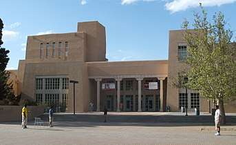
This quadrant has been experiencing a housing expansion since the late 1950s. It abuts the base of the Sandia Mountains and contains portions of the foothills neighborhoods, which are significantly higher, in elevation and price range, than the rest of the city. Running from Central Avenue and the railroad tracks to the Sandia Peak Aerial Tram, this is the largest quadrant both geographically and by population. Martineztown, the University of New Mexico, the Maxwell Museum of Anthropology, Nob Hill, the Uptown area which includes three shopping malls (Coronado Center, ABQ Uptown, and Winrock Town Center), Hoffmantown, Journal Center, Cliff's Amusement Park, and Balloon Fiesta Park are all in this quadrant.
Some of the most affluent neighborhoods in the city are here, including: High Desert, Tanoan, Sandia Heights, and North Albuquerque Acres. Parts of Sandia Heights and North Albuquerque Acres are outside the city limits proper. A few houses in the farthest reach of this quadrant lie in the Cibola National Forest, just over the line into Sandoval County.
Northwest
This quadrant contains historic Old Town Albuquerque, which dates to the 18th century, as well as the Indian Pueblo Cultural Center. The area has a mixture of commercial districts and low to high-income neighborhoods. Northwest Albuquerque includes the largest section of Downtown, Rio Grande Nature Center State Park and the Bosque ("woodlands"), Petroglyph National Monument, Double Eagle II Airport, the Paradise Hills neighborhood, Taylor Ranch, and Cottonwood Mall.
This quadrant also contains the North Valley settlement, outside the city limits, which has some expensive homes and small ranches along the Rio Grande. The city of Albuquerque engulfs the village of Los Ranchos de Albuquerque. A small portion of the rapidly developing area on the west side of the river south of the Petroglyphs, known as the "West Mesa" or "Westside", consisting primarily of traditional residential subdivisions, also extends into this quadrant. The city proper is bordered on the north by the North Valley, the village of Corrales, and the city of Rio Rancho.
Southeast

Kirtland Air Force Base, Sandia National Laboratories, Sandia Science & Technology Park, Albuquerque International Sunport, Eclipse Aerospace, American Society of Radiologic Technologists, Central New Mexico Community College, Albuquerque Veloport, University Stadium, Rio Grande Credit Union Field at Isotopes Park, The Pit, Mesa del Sol, The Pavilion, Albuquerque Studios, Isleta Resort & Casino, the National Museum of Nuclear Science & History, New Mexico Veterans' Memorial, and Talin Market are all in the Southeast quadrant.
The upscale neighborhood of Four Hills is in the foothills of Southeast Albuquerque. Other neighborhoods include Nob Hill, Ridgecrest, Willow Wood, and Volterra.
Southwest
Traditionally consisting of agricultural and rural areas and suburban neighborhoods, the Southwest quadrant comprises the south-end of Downtown Albuquerque, the Barelas neighborhood, the rapidly growing west side, and the community of South Valley, New Mexico, often called "The South Valley". Although the South Valley is not within Albuquerque's city limits, the quadrant extends through it all the way to the Isleta Indian Reservation. Newer suburban subdivisions on the West Mesa near the southwestern city limits join homes of older construction, some dating as far back as the 1940s. This quadrant includes the old communities of Atrisco, Los Padillas, Huning Castle, Kinney, Westgate, Westside, Alamosa, Mountainview, and Pajarito. The Bosque ("woodlands"), the National Hispanic Cultural Center, the Rio Grande Zoo, and Tingley Beach are also here.
A new adopted development plan, the Santolina Master Plan, will extend development on the west side past 118th Street SW to the edge of the Rio Puerco Valley and house 100,000 by 2050. It is unclear whether the Santolina development will be annexed by the City of Albuquerque or incorporated as its own city.[37]
Climate
Albuquerque's climate is classified as a dry Warm Temperate climate, as defined by The Biota of North America Program [38] and the U.S. Geological Survey's Terrestrial Ecosystems—Isobioclimates of the Conterminous United States,[39] using datasets and mapping technology such as those from the PRISM Climate Group.[40] In the Köppen climate classification system, Albuquerque's climate is classified as a Cold semi-arid climate (BSk).
| Climate data for Albuquerque (Albuquerque International Sunport), 1981–2010 normals, extremes 1891–present[lower-alpha 1] | |||||||||||||
|---|---|---|---|---|---|---|---|---|---|---|---|---|---|
| Month | Jan | Feb | Mar | Apr | May | Jun | Jul | Aug | Sep | Oct | Nov | Dec | Year |
| Record high °F (°C) | 72 (22) |
79 (26) |
85 (29) |
90 (32) |
98 (37) |
107 (42) |
105 (41) |
101 (38) |
100 (38) |
91 (33) |
83 (28) |
72 (22) |
107 (42) |
| Mean maximum °F (°C) | 60.1 (15.6) |
67.6 (19.8) |
76.1 (24.5) |
83.2 (28.4) |
91.1 (32.8) |
98.8 (37.1) |
99.4 (37.4) |
95.7 (35.4) |
91.3 (32.9) |
82.5 (28.1) |
70.8 (21.6) |
60.3 (15.7) |
100.2 (37.9) |
| Average high °F (°C) | 46.8 (8.2) |
52.5 (11.4) |
60.5 (15.8) |
69.0 (20.6) |
78.8 (26.0) |
88.3 (31.3) |
90.1 (32.3) |
87.2 (30.7) |
80.7 (27.1) |
69.0 (20.6) |
55.8 (13.2) |
46.1 (7.8) |
68.8 (20.4) |
| Daily mean °F (°C) | 36.4 (2.4) |
41.4 (5.2) |
48.1 (8.9) |
56.0 (13.3) |
65.6 (18.7) |
74.9 (23.8) |
78.3 (25.7) |
76.2 (24.6) |
69.3 (20.7) |
57.5 (14.2) |
44.9 (7.2) |
36.3 (2.4) |
57.2 (14.0) |
| Average low °F (°C) | 26.1 (−3.3) |
30.3 (−0.9) |
35.7 (2.1) |
43.0 (6.1) |
52.5 (11.4) |
61.6 (16.4) |
66.4 (19.1) |
65.1 (18.4) |
57.9 (14.4) |
46.1 (7.8) |
34.1 (1.2) |
26.5 (−3.1) |
45.5 (7.5) |
| Mean minimum °F (°C) | 14.1 (−9.9) |
16.7 (−8.5) |
22.3 (−5.4) |
29.4 (−1.4) |
39.0 (3.9) |
50.3 (10.2) |
59.4 (15.2) |
57.6 (14.2) |
46.3 (7.9) |
31.9 (−0.1) |
20.3 (−6.5) |
12.1 (−11.1) |
9.6 (−12.4) |
| Record low °F (°C) | −17 (−27) |
−10 (−23) |
6 (−14) |
13 (−11) |
25 (−4) |
35 (2) |
42 (6) |
46 (8) |
26 (−3) |
19 (−7) |
−7 (−22) |
−16 (−27) |
−17 (−27) |
| Average precipitation inches (mm) | 0.38 (9.7) |
0.48 (12) |
0.57 (14) |
0.61 (15) |
0.50 (13) |
0.66 (17) |
1.50 (38) |
1.58 (40) |
1.08 (27) |
1.02 (26) |
0.57 (14) |
0.50 (13) |
9.45 (240) |
| Average snowfall inches (cm) | 2.1 (5.3) |
1.8 (4.6) |
1.1 (2.8) |
0.6 (1.5) |
0 (0) |
0 (0) |
0 (0) |
0 (0) |
0 (0) |
0.3 (0.76) |
1.0 (2.5) |
2.7 (6.9) |
9.6 (24) |
| Average precipitation days (≥ 0.01 in) | 4.1 | 3.8 | 4.9 | 3.2 | 4.2 | 4.4 | 8.3 | 9.2 | 5.9 | 5.1 | 3.9 | 4.2 | 61.2 |
| Average snowy days (≥ 0.1 in) | 2.4 | 1.7 | 1.5 | 0.3 | 0 | 0 | 0 | 0 | 0 | 0.2 | 1.0 | 2.4 | 9.6 |
| Average relative humidity (%) | 56.3 | 49.8 | 39.7 | 32.5 | 31.1 | 29.8 | 41.9 | 47.1 | 47.4 | 45.3 | 49.9 | 56.8 | 44.0 |
| Mean monthly sunshine hours | 234.2 | 225.3 | 270.2 | 304.6 | 347.4 | 359.3 | 335.0 | 314.2 | 286.7 | 281.4 | 233.8 | 223.3 | 3,415.4 |
| Percent possible sunshine | 75 | 74 | 73 | 78 | 80 | 83 | 76 | 75 | 77 | 80 | 75 | 73 | 77 |
| Source: NOAA (relative humidity and sun 1961–1990)[41][42][43] | |||||||||||||
| Climate data for Albuquerque South Valley (elevation 4,955 ft (1,510.3 m), 1981–2010 normals, extremes 1991–present) | |||||||||||||
|---|---|---|---|---|---|---|---|---|---|---|---|---|---|
| Month | Jan | Feb | Mar | Apr | May | Jun | Jul | Aug | Sep | Oct | Nov | Dec | Year |
| Record high °F (°C) | 73 (23) |
79 (26) |
86 (30) |
90 (32) |
101 (38) |
105 (41) |
103 (39) |
101 (38) |
96 (36) |
89 (32) |
76 (24) |
70 (21) |
105 (41) |
| Average high °F (°C) | 50.3 (10.2) |
56.2 (13.4) |
63.4 (17.4) |
71.7 (22.1) |
80.1 (26.7) |
89.3 (31.8) |
91.4 (33.0) |
89.1 (31.7) |
82.4 (28.0) |
71.3 (21.8) |
59.0 (15.0) |
49.3 (9.6) |
71.2 (21.8) |
| Daily mean °F (°C) | 35.6 (2.0) |
40.9 (4.9) |
47.6 (8.7) |
55.4 (13.0) |
63.8 (17.7) |
72.3 (22.4) |
76.7 (24.8) |
75.3 (24.1) |
67.8 (19.9) |
55.9 (13.3) |
43.7 (6.5) |
35.5 (1.9) |
55.9 (13.3) |
| Average low °F (°C) | 20.9 (−6.2) |
25.6 (−3.6) |
31.7 (−0.2) |
39.0 (3.9) |
47.5 (8.6) |
55.3 (12.9) |
62.0 (16.7) |
61.5 (16.4) |
53.1 (11.7) |
40.4 (4.7) |
28.5 (−1.9) |
21.7 (−5.7) |
40.7 (4.8) |
| Record low °F (°C) | −4 (−20) |
−5 (−21) |
6 (−14) |
22 (−6) |
26 (−3) |
41 (5) |
47 (8) |
44 (7) |
36 (2) |
19 (−7) |
9 (−13) |
2 (−17) |
−5 (−21) |
| Average precipitation inches (mm) | 0.46 (12) |
0.53 (13) |
0.67 (17) |
0.62 (16) |
0.54 (14) |
0.58 (15) |
1.44 (37) |
1.72 (44) |
1.25 (32) |
1.13 (29) |
0.64 (16) |
0.63 (16) |
10.21 (259) |
| Average snowfall inches (cm) | 1.7 (4.3) |
0.7 (1.8) |
0.9 (2.3) |
0.4 (1.0) |
0 (0) |
0 (0) |
0 (0) |
0 (0) |
0 (0) |
0.2 (0.51) |
0.5 (1.3) |
2.8 (7.1) |
7.2 (18) |
| Average precipitation days (≥ 0.01 in) | 3.9 | 4.0 | 4.5 | 3.2 | 3.7 | 4.3 | 8.2 | 8.9 | 5.3 | 4.9 | 3.0 | 3.9 | 57.8 |
| Average snowy days (≥ 0.1 in) | 1.4 | 0.6 | 0.5 | 0.2 | 0 | 0 | 0 | 0 | 0 | 0.1 | 0.4 | 1.3 | 4.5 |
| Source: NOAA[44] | |||||||||||||
| Climate data for Albuquerque Foothills (elevation 6,120 ft (1,865.4 m), 1981–2010 normals) | |||||||||||||
|---|---|---|---|---|---|---|---|---|---|---|---|---|---|
| Month | Jan | Feb | Mar | Apr | May | Jun | Jul | Aug | Sep | Oct | Nov | Dec | Year |
| Average high °F (°C) | 46.0 (7.8) |
51.5 (10.8) |
59.6 (15.3) |
68.9 (20.5) |
78.6 (25.9) |
87.8 (31.0) |
89.4 (31.9) |
86.5 (30.3) |
79.7 (26.5) |
67.3 (19.6) |
54.4 (12.4) |
44.8 (7.1) |
68.0 (20.0) |
| Daily mean °F (°C) | 36.4 (2.4) |
40.7 (4.8) |
47.1 (8.4) |
54.9 (12.7) |
64.0 (17.8) |
73.1 (22.8) |
75.8 (24.3) |
73.5 (23.1) |
67.1 (19.5) |
55.5 (13.1) |
43.7 (6.5) |
35.6 (2.0) |
55.7 (13.2) |
| Average low °F (°C) | 26.7 (−2.9) |
30.0 (−1.1) |
34.6 (1.4) |
41.0 (5.0) |
49.5 (9.7) |
58.3 (14.6) |
62.2 (16.8) |
60.6 (15.9) |
54.5 (12.5) |
43.6 (6.4) |
33.1 (0.6) |
26.5 (−3.1) |
43.4 (6.3) |
| Average precipitation inches (mm) | 0.76 (19) |
0.82 (21) |
1.36 (35) |
1.03 (26) |
0.82 (21) |
0.71 (18) |
2.25 (57) |
2.97 (75) |
1.54 (39) |
1.54 (39) |
1.29 (33) |
1.21 (31) |
16.30 (414) |
| Average snowfall inches (cm) | 4.7 (12) |
3.9 (9.9) |
5.0 (13) |
2.0 (5.1) |
trace | 0 (0) |
0 (0) |
0 (0) |
0 (0) |
0.6 (1.5) |
3.0 (7.6) |
7.3 (19) |
26.5 (67) |
| Average precipitation days (≥ 0.01 in) | 5.6 | 6.0 | 6.3 | 4.6 | 5.6 | 4.9 | 11.8 | 10.7 | 7.5 | 6.5 | 5.0 | 6.3 | 80.8 |
| Average snowy days (≥ 0.1 in) | 3.9 | 3.2 | 3.1 | 1.4 | 0.1 | 0 | 0 | 0 | 0 | 0.5 | 1.7 | 4.3 | 18.2 |
| Source: NOAA[45] | |||||||||||||
Albuquerque is located at the crossroads of several ecoregions. According to the U.S. Environmental Protection Agency,[46] the city is located in the southeastern edge of the Arizona/New Mexico Plateau, with the Arizona/New Mexico Mountains ecoregion defining the adjacent Sandia-Manzano mountains, including the foothills in the eastern edges of the city proper east of Juan Tabo or Tramway boulevards. Though the city lies to the north of the Chihuahuan Desert, parts of Albuquerque shares a similar aridity, temperature regime, and natural vegetation to that of the Chihuahuan Desert, namely the upper elevations with desert grassland and sand scrub plant communities.[47] The eastern areas of the Greater Albuquerque Area, known as the East Mountain Area, lie the Southwestern Tablelands and are sometimes considered a southern extension of the central high plains and northeast New Mexico highlands. To the north is the Southern Rockies ecoregion in the Jemez Mountains.
The average annual precipitation is less than half of evaporation providing an arid climate, and no month's daily temperature averages below freezing. Daytime weather is typically rather mild compared to parts of the country further north or further south. However, due to the city's high elevation, daily temperature differences can vary widely and low temperatures in winter typically dip well below freezing. The daily average temperatures in December and January, the coldest months, are slightly above freezing at 36.3 °F (2.4 °C) and 36.4 °F (2.4 °C) respectively.
Albuquerque's climate is usually sunny and dry, with an average of 3,415 sunshine hours per year.[43][48] Brilliant sunshine defines the region, averaging 278 days a year; periods of variably mid and high-level cloudiness temper the sun, mostly during the cooler months. Extended cloudiness lasting longer than two or three days is rare.
Winter typically consists of cool days and cold nights, except following passage of the strongest cold fronts and arctic airmasses when daytime temperatures remain colder than average; overnight temperatures tend to fall below freezing between about 10 pm and 8 am in the city, except during colder airmasses, plus colder spots of the valley and most of the East Mountain areas. December, the coolest month, averages 36.3 °F (2.4 °C), although extreme low temperatures bottom out in early January; the median or normal coolest temperature of the year is just above 10 °F (−12 °C), though the average or mean is below 10 °F (−12 °C).[49][50] It is typical for daily low temperatures in much of December, January, and February to be below freezing, the long-term average 76 of 90 days falling to or below freezing; four 24 hour days stay below freezing on average, though that often occurs for less hours west of the Rio Grande and in the Heights.[50]
Spring is windy, sometimes unsettled with rain, though spring is usually the driest part of the year in Albuquerque. March and April tend to experience many days with the wind blowing at 20 to 30 mph (32 to 48 km/h), and afternoon gusts can produce periods of blowing sand and dust. In May, the winds tend to subside as a summer-like airmass and temperatures begin to occur with regularity.
Summer is lengthy and very warm to hot, relatively tolerable for most people because of low humidity and air movement. The exception is some days during the North American Monsoon, when daily humidity remains relatively high, especially in July and August. 2.7 days of 100 °F (38 °C) or warmer highs occur annually on average, mostly in June and July and rarely in August due in part to the monsoon; an average of 60 days experience 90 °F (32 °C) or warmer highs. 28 days with highs at or above 100 °F (38 °C) occurred in the summer of 1980 at Albuquerque's Sunport,[51] though such temperatures are a rare occurrence. Portions of the valley and West Mesa locations experience more high temperatures above 90 °F (32 °C) and 100 °F (38 °C) as part of normal or extreme weather each summer.
Fall is generally cool in the mornings and nights but sees less rain than summer, though the weather can be more unsettled closer to winter, as colder airmasses and weather patterns build in from the north and northwest with more frequency.
Precipitation averages about 9.5 inches per year using recent 30-year periods, but during the period of record beginning in 1897, the average is 8.7 inches.[50] On average, January is the driest month, while July and August are the wettest months, as a result of shower and thunderstorm activity produced by the North American Monsoon prevalent over the Southwestern United States. Most rain occurs during the late summer monsoon season, typically starting in early July and ending in mid-September.
Albuquerque averages about 10 inches of snow per winter,[52] and experiences several accumulating snow events each season. Locations in the Northeast Heights and Eastern Foothills tend to receive more snowfall due to each region's higher elevation and proximity to the mountains. The city was one of several in the region experiencing a severe winter storm on December 28–30, 2006, with locations in Albuquerque receiving between 10.5 and 26 inches (27 and 66 cm) of snow.[53] More recently, a major winter storm in late February 2015 dropped up to a foot (30 cm) of snow on most of the city. Such large snowfalls are rare occurrences during the period of record, and they greatly impact traffic movement and the workforce throughout the city due to their rarity.
The mountains and highlands east of the city create a rain shadow effect, due to the drying of air descending the mountains; the city usually receives very little rain or snow, averaging 8–9 inches (216 mm) of precipitation per year. Valley and west mesa areas, farther from the mountains are drier, averaging 6–8 inches of annual precipitation; the Sandia foothills tend to lift any available moisture, enhancing precipitation to about 10–17 inches annually.
Traveling west, north, and east of Albuquerque, one quickly rises in elevation and leaves the sheltering effect of the valley to enter a noticeably cooler and slightly wetter environment. One such area is considered part of Albuquerque Metropolitan Area, commonly called the East Mountain area; it is covered in woodlands of juniper and piñon trees, a common trait of southwestern uplands and the southernmost Rocky Mountains.
Hydrology
Albuquerque's drinking water comes from a combination of Rio Grande water (river water diverted from the Colorado River basin through the San Juan-Chama Project[54]) and a delicate aquifer that has been described as an "underground Lake Superior". The Albuquerque Bernalillo County Water Utility Authority (ABCWUA) has developed a water resources management strategy that pursues conservation and the direct extraction of water from the Rio Grande for the development of a stable underground aquifer in the future.[55][56]
The aquifer of the Rio Puerco is too saline to be cost-effectively used for drinking. Much of the rainwater Albuquerque receives does not recharge its aquifer. It is diverted through a network of paved channels and arroyos and empties into the Rio Grande.
Of the 62,780 acre feet (77,440,000 m3) per year of the water in the upper Colorado River basin entitled to municipalities in New Mexico by the Upper Colorado River Basin Compact, Albuquerque owns 48,200. The water is delivered to the Rio Grande by the San Juan–Chama Project. The project's construction was initiated by legislation signed by President John F. Kennedy in 1962, and was completed in 1971. This diversion project transports water under the continental divide from Navajo Lake to Lake Heron on the Rio Chama, a tributary of the Rio Grande. In the past much of this water was resold to downstream owners in Texas. These arrangements ended in 2008 with the completion of the ABCWUA's Drinking Water Supply Project.[57]
The ABCWUA's Drinking Water Supply Project uses a system of adjustable-height dams to skim water from the Rio Grande into sluices that lead to water treatment facilities for direct conversion to potable water. Some water is allowed to flow through central Albuquerque, mostly to protect the endangered Rio Grande Silvery Minnow. Treated effluent water is recycled into the Rio Grande south of the city. The ABCWUA expects river water to comprise up to seventy percent of its water budget in 2060. Groundwater will constitute the remainder. One of the policies of the ABCWUA's strategy is the acquisition of additional river water.[56][58] :Policy G, 14
Demographics
| Historical population | |||
|---|---|---|---|
| Census | Pop. | %± | |
| 1880 | 2,315 | — | |
| 1890 | 3,785 | 63.5% | |
| 1900 | 6,238 | 64.8% | |
| 1910 | 11,020 | 76.7% | |
| 1920 | 15,157 | 37.5% | |
| 1930 | 26,570 | 75.3% | |
| 1940 | 35,449 | 33.4% | |
| 1950 | 96,815 | 173.1% | |
| 1960 | 201,189 | 107.8% | |
| 1970 | 244,501 | 21.5% | |
| 1980 | 332,920 | 36.2% | |
| 1990 | 384,736 | 15.6% | |
| 2000 | 448,607 | 16.6% | |
| 2010 | 545,852 | 21.7% | |
| Est. 2019 | 560,513 | [2] | 2.7% |
| U.S. Decennial Census[59] | |||
| Demographic profile | 2010[60] | 1990[20] | 1970[20] | 1950[20] |
|---|---|---|---|---|
| White | 69.7% | 78.2% | 95.7% | 98.0% |
| —Non-Hispanic | 42.1% | 58.3% | 63.3% | N/A |
| Black or African American | 3.3% | 3.0% | 2.2% | 1.3% |
| Hispanic or Latino (of any race) | 46.7% | 34.5% | 33.1% | N/A |
| Asian | 2.6% | 1.7% | 0.3% | 0.1% |
As of the United States census of 2010, there were 545,852 people, 239,166 households, and 224,330 families residing in the city.[61] The population density was 3010.7/mi² (1162.6/km²). There were 239,166 housing units at an average density of 1,556.7 per square mile (538.2/km²).
The racial makeup of the city was 69.7% White (Non-Hispanic white 42.1%), 4.6% Native American, 3.3% Black or African American, 2.6% Asian, 0.1% Native Hawaiian and other Pacific Islander, and 4.6% Multiracial (two or more races).[62][63]
The ethnic makeup of the city was 46.7% of the population being Hispanics or Latinos of any race.[62]
There were 239,116 households out of which 33.3% had children under the age of 18 living with them, 43.6% were married couples living together, 12.9% had a female householder with no husband present, and 38.5% were non-families. 30.5% of all households were made up of individuals and 8.4% had someone living alone who was 65 years of age or older. The average household size was 2.40 and the average family size was 3.02.
The age distribution was 24.5% under 18, 10.6% from 18 to 24, 30.9% from 25 to 44, 21.9% from 45 to 64, and 12.0% who were 65 or older. The median age was 35 years. For every 100 females, there were 94.4 males. For every 100 females age 18 and over, there were 91.8 males.
The median income for a household in the city was $38,272, and the median income for a family was $46,979. Males had a median income of $34,208 versus $26,397 for females. The per capita income for the city was $20,884. About 10.0% of families and 13.5% of the population were below the poverty line, including 17.4% of those under age 18 and 8.5% of those age 65 or over.
Religion
According to a study by Sperling's BestPlaces, the majority of the religious population in Albuquerque are Christian.[64]
Being a historical Spanish and Mexican city, the Catholic Church is the largest Christian church in Albuquerque. The Catholic population of Albuquerque is served by the Roman Catholic Archdiocese of Santa Fe, whose administrative center is located in the city. Collectively, other Christian churches and organizations such as the Eastern Orthodox Church, Oriental Orthodoxy, and others make up the second largest group in the city. Baptists form the third largest Christian group, followed by the Latter Day Saints, Pentecostals, Methodists, Presbyterians, Lutherans and Episcopalians.
The second largest religious population in the city are eastern religions such as Buddhism, Sikhism, and Hinduism.[64] The Albuquerque Sikh Gurudwara and Guru Nanak Gurdwara Albuquerque serve the city's Sikh populace; the Hindu Temple Society of New Mexico serves the Hindu population; several Buddhist temples and centers are located in the city limits.
Judaism is the second-largest non-Christian religious group in Albuquerque, followed by Islam.[64] Congregation Albert is a Reform synagogue established in 1897.[18] It is the oldest continuing Jewish organization in the city.
Arts and culture
One of the major art events in the state is the summertime New Mexico Arts and Crafts Fair, a nonprofit show exclusively for New Mexico artists and held annually in Albuquerque since 1961.[65][66] Albuquerque is home to over 300 other visual arts, music, dance, literary, film, ethnic, and craft organizations, museums, festivals and associations.
Points of interest

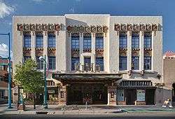
Local museums, galleries, shops and other points of interest include the Albuquerque Biological Park, Albuquerque Museum, New Mexico Museum of Natural History and Science, and Old Town Albuquerque. Albuquerque's live music/performance venues include Isleta Amphitheater, Tingley Coliseum, Sunshine Theater and the KiMo Theater.
Local cuisine prominently features green chile, which is widely available in restaurants, including national fast-food chains. Albuquerque has an active restaurant scene, and local restaurants receive statewide attention, several of them having become statewide chains.
The Sandia Peak Tramway, adjacent to Albuquerque, is the world's second-longest passenger aerial tramway. It also has the world's third-longest single span. It stretches from the northeast edge of the city to the crestline of the Sandia Mountains. Elevation at the top of the tramway is roughly 10,300 ft (3,100 m) above sea level.
International Balloon Fiesta
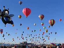
The Albuquerque International Balloon Fiesta takes place at Balloon Fiesta Park the first week of October. It is one of Albuquerque's biggest attractions. Hundreds of hot-air balloons are seen every day, and there is live music, arts and crafts, and food.[67]
Architecture
John Gaw Meem, credited with developing and popularizing the Pueblo Revival style, was based in Santa Fe but received an important Albuquerque commission in 1933 as the architect of the University of New Mexico. He retained this commission for the next quarter-century and developed the university's distinctive Southwest style.[17] :317 Meem also designed the Cathedral Church of St. John in 1950.[68]
Albuquerque boasts a unique nighttime cityscape. Many building exteriors are illuminated in vibrant colors such as green and blue. The Wells Fargo Building is illuminated green. The DoubleTree Hotel changes colors nightly, and the Compass Bank building is illuminated blue. The rotunda of the county courthouse is illuminated yellow, while the tops of the Bank of Albuquerque and the Bank of the West are illuminated reddish-yellow. Due to the nature of the soil in the Rio Grande Valley, the skyline is lower than might be expected in a city of comparable size elsewhere.

Albuquerque has expanded greatly in area since the mid-1940s. During those years of expansion, the planning of the newer areas has considered that people drive rather than walk. The pre-1940s parts of Albuquerque are quite different in style and scale from the post-1940s areas. The older areas include the North Valley, the South Valley, various neighborhoods near downtown, and Corrales. The newer areas generally feature four- to six-lane roads in a 1 mile (1.61 km) grid. Each 1 square mile (2.59 km²) is divided into four 160-acre (0.65 km2) neighborhoods by smaller roads set 0.5 miles (0.8 km) between major roads. When driving along major roads in the newer sections of Albuquerque, one sees strip malls, signs, and cinderblock walls. The upside of this planning style is that neighborhoods are shielded from the worst of the noise and lights on the major roads. The downside is that it is virtually impossible to go anywhere without driving.
Libraries
The Albuquerque and Bernalillo County Library System consists of eighteen libraries to serve Albuquerque, New Mexico.[69] The Old Main Library was the first library of Albuquerque and from 1901 until 1948 it was the only public library. The original library was donated to the state by Joshua and Sarah Raynolds. After suffering some fire damage in 1923 the city decided it was time to construct a building for the library to be moved to, however, by 1970 even after additions were made the population and library needs had outgrown the building for its use as a main library and it was turned into Special Collections. The Old Main Library was recognized as a landmark in September 1979. It was not until 1974 with the movement of the South Valley Library into a new building that the Bernalillo built and administered a public library. Not long after, in 1986, the Bernalillo and Albuquerque government decided that joint powers would work best to serve the needs of the community and created the Albuquerque/Bernalillo County Library System.[70]
The Library Branches:[71]
- Alamosa Public Library
- Central & Unser Public Library
- Cherry Hills Public Library
- East Mountain Public Library
- Erna Fergusson Public Library
- Ernie Pyle Public Library
- Juan Tabo Public Library
- Lomas Tramway Public Library
- Los Griegos Public Library
- Main Public Library
- Rudolfo Anaya North Valley Library
- San Pedro Public Library
- South Broadway Public Library
- South Valley Public Library
- Special Collections Public Library
- Taylor Ranch Public Library
- Tony Hillerman Public Library
- Westgate Heights Public Library
Parks and recreation
According to the Trust for Public Land, Albuquerque has 291 public parks as of 2017, most of which are administered by the city Parks and Recreation Department. The total amount of parkland is 42.9 square miles (111 km2), or about 23% of the city's total area—one of the highest percentages among large cities in the U.S. About 82% of city residents live within walking distance of a park.
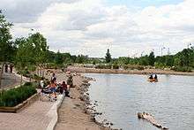
Albuquerque has a botanical and zoological complex called the Albuquerque Biological Park, consisting of the Rio Grande Botanic Garden, Albuquerque Aquarium, Tingley Beach, and the Rio Grande Zoo.
Sports
The Albuquerque Isotopes are a minor league affiliate of the Colorado Rockies, having derived their name from The Simpsons season 12 episode "Hungry, Hungry Homer", which involves the Springfield Isotopes baseball team considering relocating to Albuquerque.[72][73] Prior to 2002, the Albuquerque Dukes were the city's minor league team. The team played at the Albuquerque Sports Stadium which was demolished to make room for the current Rio Grande Credit Union Field at Isotopes Park.
The Albuquerque Sol soccer club began play in USL League Two in 2014.[74] On June 6, 2018, the United Soccer League announced its latest expansion club with USL New Mexico, headquartered in Albuquerque. Albuquerque is also home to Jackson-Winkeljohn gym, a mixed martial arts (MMA) gym. Several MMA world champions and fighters, including Holly Holm and Jon Jones, train in that facility.[75][76] Roller sports are finding a home in Albuquerque as they hosted USARS Championships in 2015,[77] and are home to Roller hockey,[78] and Roller Derby teams.[79]
| Team | Sport | League | Venue | capacity |
|---|---|---|---|---|
| Albuquerque Isotopes | Baseball | AAA PCL | Rio Grande Credit Union Field at Isotopes Park | 13,279 |
| New Mexico United | Soccer | USL Championship | Rio Grande Credit Union Field at Isotopes Park | 13,279 |
| Albuquerque Sol | Soccer | USL League Two | Ben Rios Field | 1,500 |
| Duke City Gladiators | Indoor Football | Indoor Football League | Tingley Coliseum | 11,571 |
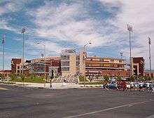
| New Mexico Lobos | NCAA Division I FBS Football | Mountain West Conference | University Stadium | 42,000 |
| New Mexico Lobos (men and women) | NCAA Division I Basketball | Mountain West Conference | The Pit | 15,411 |
| Duke City Roller Derby | Roller Derby | Wells Park Community Center |
Government and politics
| Albuquerque registered voters as of July 2016[80] | |||||
|---|---|---|---|---|---|
| Party | Number of Voters | Percentage | |||
| Democratic | 123,594 | 40.03% | |||
| Republican | 104,662 | 34.13% | |||
| Unaffiliated and third party | 78,404 | 25.57% | |||
Albuquerque is a charter city.[81][82] City government is divided into an executive branch, headed by a mayor[81]:V and a nine-member council that holds the legislative authority.[81]:IV The form of city government is therefore mayor-council government. The mayor is Tim Keller a former state auditor and senator, who was elected in 2017.
The Mayor of Albuquerque holds a full-time paid elected position with a four-year term.[83] Albuquerque City Council members hold part-time paid positions and are elected from the nine districts for four-year terms, with four or five Councilors elected every two years.[84] Elections for mayor and Councilor are nonpartisan.[81]:IV.4[82] Each December, a new Council President and Vice-President are chosen by members of the Council.[83] Each year, the mayor submits a city budget proposal for the year to the Council by April 1, and the Council acts on the proposal within the next 60 days.[81]:VII
The Albuquerque City Council is the legislative authority of the city, and has the power to adopt all ordinances, resolutions, or other legislation.[84] The council meets two times a month, with meetings held in the Vincent E. Griego Council Chambers in the basement level of Albuquerque/Bernalillo County Government Center.[85] Ordinances and resolutions passed by the council are presented to the mayor for his approval. If the mayor vetoes an item, the Council can override the veto with a vote of two-thirds of the membership of the Council.[81]:XI.3
The judicial system in Albuquerque includes the Bernalillo County Metropolitan Court.
Police department
The Albuquerque Police Department (APD) is the police department with jurisdiction within the city limits, with anything outside of the city limits being considered the unincorporated area of Bernalillo County and policed by the Bernalillo County Sheriff's Department. It is the largest municipal police department in New Mexico, and in September 2008 the US Department of Justice recorded the APD as the 49th largest police department in the United States.[86]
In November 2012, the United States Department of Justice launched an investigation into APD's policies and practices to determine whether APD engages in a pattern or practice of use of excessive force in violation of the Fourth Amendment and the Violent Crime Control and Law Enforcement Act of 1994, 42 U.S.C. § 14141 ("Section 14141").[87] As part of its investigation, the Department of Justice consulted with police practices experts and conducted a comprehensive assessment of officers' use of force and APD policies and operations. The investigation included tours of APD facilities and Area Commands; interviews with Albuquerque officials, APD command staff, supervisors, and police officers; a review of numerous documents; and meetings with the Albuquerque Police Officers Association, residents, community groups, and other stakeholders.[87] When the Department of Justice concluded its investigation, it issued a scathing report that uncovered a "culture of acceptance of the use of excessive force" involving significant harm or injury by APD officers against people who posed no threat and which was not justified by the circumstances. The DOJ recommended a nearly complete overhaul of the department's use-of-force policies. Among several systematic problems at APD were an aggressive culture that undervalued civilian safety and discounted the importance of crisis intervention.[88]
Economy
| Largest employers in Albuquerque | |
|---|---|
| 1 | Kirtland Air Force Base |
| 2 | University of New Mexico |
| 3 | Sandia National Laboratories |
| 4 | Albuquerque Public Schools |
| 5 | Presbyterian Healthcare Services |
| 6 | City government |
| 7 | Lovelace–Sandia Health System |
| 8 | Presbyterian Medical Services |
| 9 | Intel Corporation |
| 10 | State of New Mexico (Government) |
| 11 | Wal-Mart Stores, Inc. |
Albuquerque lies at the center of the New Mexico Technology Corridor, a concentration of high-tech private companies and government institutions along the Rio Grande. Larger institutions whose employees contribute to the population are numerous and include Sandia National Laboratories, Kirtland Air Force Base, and the attendant contracting companies which bring highly educated workers to a somewhat isolated region. Intel operates a large semiconductor factory or "fab" in suburban Rio Rancho, in neighboring Sandoval County, with its attendant large capital investment. Northrop Grumman is located along I-25 in northeast Albuquerque, and Tempur-Pedic is located on the West Mesa next to I-40.
The solar energy and architectural-design innovator Steve Baer located his company, Zomeworks, to the region in the late 1960s; and Los Alamos National Laboratory, Sandia, and Lawrence Livermore National Laboratory cooperate here in an enterprise that began with the Manhattan Project. In January 2007, Tempur-Pedic opened an 800,000-square-foot (74,000 m2) mattress factory in northwest Albuquerque. SCHOTT Solar, Inc., announced in January 2008 they would open a 200,000-square-foot (19,000 m2) facility manufacturing receivers for concentrated solar thermal power plants (CSP) and 64MW of photovoltaic (PV) modules. The facility closed in 2012.
Forbes magazine rated Albuquerque as the best city in America for business and careers in 2006[89] and as the 13th best (out of 200 metro areas) in 2008.[90] The city was rated seventh among America's Engineering Capitals in 2014 by Forbes magazine.[91] Albuquerque ranked among the Top 10 Best Cities to Live by U.S. News & World Report in 2009[92] and was recognized as the fourth best place to live for families by the TLC network.[93] It was ranked among the Top Best Cities for Jobs in 2007 and among the Top 50 Best Places to Live and Play by National Geographic Adventure.[94][95]
Education
Albuquerque is home to the University of New Mexico, the largest public flagship university in the state. UNM includes a School of Medicine which was ranked in the top 50 primary care-oriented medical schools in the country.[96] Central New Mexico Community College is a county-funded junior college serving new high school graduates and adults returning to school.
Albuquerque is also home to the following programs and non-profit schools of higher learning: Southwest University of Visual Arts, Southwestern Indian Polytechnic Institute, Trinity Southwest University, the University of St. Francis College of Nursing and Allied Health Department of Physician Assistant Studies, and the St. Norbert College Master of Theological Studies program.[97] The Ayurvedic Institute, one of the first Ayurveda colleges specializing in Ayurvedic medicine outside of India was established in the city in 1984. Other state and not-for-profit institutions of higher learning have moved some of their programs into Albuquerque. These include: New Mexico State University, Highlands University, Lewis University, Wayland Baptist University, and Webster University. Several for-profit technical schools including Brookline College, Pima Medical Institute, National American University, Grand Canyon University, the University of Phoenix and several barber/beauty colleges have established their presence in the area.
Albuquerque Public Schools (APS), one of the largest school districts in the nation, provides educational services to almost 100,000 children across the city. Schools within APS include both public and charter entities. Numerous accredited private preparatory schools also serve Albuquerque students. These include various pre-high school religious (Christian, Jewish, Islamic) affiliates and Montessori schools, as well as Menaul School, Albuquerque Academy, St. Pius X High School, Sandia Preparatory School, the Bosque School, Evangel Christian Academy, Hope Christian School, Hope Connection School, Shepherd Lutheran School,[98] Temple Baptist Academy, and Victory Christian. Accredited private schools serving students with special education needs in Albuquerque include: Desert Hills, Pathways Academy, and Presbyterian Ear Institute Oral School. The New Mexico School for the Deaf runs a preschool for children with hearing impairments in Albuquerque.
Infrastructure
Transportation
Main highways
Some of the main highways in the metro area include:
- Pan-American Freeway:[99]:248 More commonly known as Interstate 25 or "I-25", it is the main north–south highway on the city's eastern side of the Rio Grande. It is also the main north–south highway in the state (by connecting Albuquerque with Santa Fe and Las Cruces) and a plausible route of the eponymous Pan American Highway. Since Route 66 was decommissioned in the 1980s, the only remaining US highway in Albuquerque, unsigned US-85, shares its alignment with I-25. US-550 splits off to the northwest from I-25/US-85 in Bernalillo.
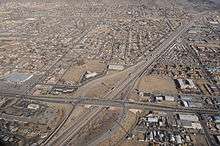 Aerial view of Interstate 40
 - Coronado Freeway:[99]:248 More commonly known as Interstate 40 or "I-40", it is the city's main east–west traffic artery and an important transcontinental route. The freeway's name in the city is in reference to 16th century conquistador and explorer Francisco Vásquez de Coronado.
- Paseo del Norte: (aka; New Mexico State Highway 423): This 6-lane controlled-access highway is approximately five miles north of Interstate 40. It runs as a surface road with at-grade intersections from Tramway Blvd (at the base of the Sandia Mountains) to Interstate 25, after which it continues as a controlled-access freeway through Los Ranchos de Albuquerque, over the Rio Grande to North Coors Boulevard. Paseo Del Norte then continues west as a surface road through the Petroglyph National Monument until it reaches Atrisco Vista Blvd and the Double Eagle II Airport. The interchange with Interstate 25 was reconstructed in 2014 to improve traffic flow.[100]
- Coors Boulevard: Coors is the main north-south artery to the west of the Rio Grande in Albuquerque. There is one full interchange where it connects with Interstate 40; The rest of the route connects to other roads with at-grade intersections controlled by stoplights. The Interstate 25 underpass has no access to Coors. Parts of the highway have sidewalks, bike lanes, and medians, but most sections have only dirt shoulders and a center turn lane. To the north of Interstate 40, part of the route is numbered as State Highway 448, while to the south, part of the route is numbered as State Highway 45.
- Rio Bravo Boulevard: The main river crossing between Westside Albuquerque and the Sunport, Rio Bravo is a four-lane divided highway that runs from University Boulevard in the east, through the South Valley, to Coors Boulevard in the west where it is contiguous with Dennis Chaves Blvd. It follows NM-500 for its entire route.
- Central Avenue: Central is one of the historical routings of Route 66, it is no longer a main through highway, its usefulness having been supplanted by Interstate 40.[99]:248
- Alameda Boulevard: The main road between Rio Rancho and North Albuquerque, Alameda Blvd. stretches from Tramway Rd. to Coors. Blvd. The route is designated as the eastern portion of NM-528.
- Tramway Boulevard: Serves as a bypass around the northeastern quadrant, the route is designated as NM-556. Tramway Boulevard starts at I-25 near Sandia Pueblo, and heads east as a two-lane road. It turns south near the base of the Sandia Peak Tramway and becomes an expressway-type divided highway until its terminus near I-40 and Central Avenue by the western entrance to Tijeras Canyon.
The interchange between I-40 and I-25 is known as the "Big I".[99]:248 Originally built in 1966, it was rebuilt in 2002. The Big I is the only five-level stack interchange in the state of New Mexico.
Bridges
There are six road bridges that cross the Rio Grande and serve the municipality on at least one end if not both. The eastern approaches of the northernmost three all pass through adjacent unincorporated areas, the Village of Los Ranchos de Albuquerque, or the North Valley. In downstream order they are:
- Alameda Bridge
- Paseo del Norte Bridge
- Montaño Bridge
- I-40 Bridge
- Central at Old Town Bridge
- Barelas Bridge
Two more bridges serve urbanized areas contiguous to the city's perforated southern boundary.
- Rio Bravo Bridge (NM-500)
- I-25 Bridge (near Isleta Pueblo)
Rail

The state owns most of the city's rail infrastructure which is used by a commuter rail system, long distance passenger trains, and the freight trains of the BNSF Railway.
Freight service
BNSF Railway operates a small yard operation out of Abajo yard, located just south of the César E. Chávez Ave. overpass and the New Mexico Rail Runner Express yards. Most freight traffic through the Central New Mexico region is processed via a much larger hub in nearby Belen, New Mexico.
Intercity rail
Amtrak's Southwest Chief, which travels between Chicago and Los Angeles, serves the Albuquerque area daily with one stop in each direction at the Alvarado Transportation Center in downtown.
Commuter rail
The New Mexico Rail Runner Express, a commuter rail line, began service between Sandoval County and Albuquerque in July 2006 using an existing BNSF right-of-way which was purchased by New Mexico in 2005. Service expanded to Valencia County in December 2006 and to Santa Fe on December 17, 2008. Rail Runner now connects Santa Fe, Sandoval, Bernalillo, and Valencia Counties with thirteen station stops, including three stops within Albuquerque.[101] The trains connect Albuquerque to downtown Santa Fe with eight roundtrips per weekday. The section of the line running south to Belen is served less frequently.[102]
Local mass transit
Albuquerque was one of two cities in New Mexico to have had electric street railways. Albuquerque's horse-drawn streetcar lines were electrified during the first few years of the 20th century. The Albuquerque Traction Company assumed operation of the system in 1905. The system grew to its maximum length of 6 miles (9.7 km) during the next ten years by connecting destinations such as Old Town to the west and the University of New Mexico to the east with the town's urban center near the former Atchison, Topeka & Santa Fe Railway depot. The Albuquerque Traction Company failed financially in 1915 and the vaguely named City Electric Company was formed. Despite traffic booms during the first world war, and unaided by lawsuits attempting to force the streetcar company to pay for paving, that system also failed later in 1927, leaving the streetcar's "motorettes" unemployed.[103]:177–181
Today, Alvarado Station provides convenient access to other parts of the city via the city bus system, ABQ RIDE. ABQ RIDE operates a variety of bus routes, including the Rapid Ride express bus service.
In 2006, the City of Albuquerque under the administration of Mayor Martin Chavez had planned and attempted to "fast track" the development of a "Modern Streetcar" project. Funding for the US$270 million system was not resolved as many citizens vocally opposed the project. The city and its transit department maintain a policy commitment to the streetcar project.[104] The project would run mostly in the southeast quadrant on Central Avenue and Yale Boulevard.
As of 2011, the city is working on a study to develop a bus rapid transit system through the Central Ave. corridor. This corridor carried 44% of all bus riders in the ABQ Ride system, making it a natural starting point for enhanced service.[105] In 2017, the city moved forward with the plans, and began construction on Albuquerque Rapid Transit, or ART, including dedicated bus lanes between Coors and Louisiana Boulevards.[106]
Bicycle transit
Albuquerque has a well-developed bicycle network.[107] In and around the city there are trails, bike routes, and paths that provide the residents and visitors with alternatives to motorized travel. In 2009, the city was reviewed as having a major up and coming bike scene in North America.[108] The same year, the City of Albuquerque opened its first Bicycle Boulevard on Silver Avenue.[109] There are plans for more investment in bikes and bike transit by the city, including bicycle lending programs, in the coming years.[110]
Walkability
A 2011 study by Walk Score ranked Albuquerque below average at 28th most walkable of the fifty largest U.S. cities.[111]
Airports

Albuquerque is served by two airports, the larger of which is Albuquerque International Sunport. It is located 3 mi (4.8 km) southeast of the central business district of Albuquerque. The Albuquerque International Sunport served 5,888,811 passengers in 2009.[112] Double Eagle II Airport is the other airport. It is primarily used as an air ambulance, corporate flight, military flight, training flight, charter flight, and private flight facility.[113]
Utilities
Energy
PNM Resources, New Mexico's largest electricity provider, is based in Albuquerque. They serve about 487,000 electricity customers statewide. New Mexico Gas Company provides natural gas services to more than 500,000 customers in the state, including the Albuquerque metro area.
Sanitation
The Albuquerque Bernalillo County Water Utility Authority is responsible for the delivery of drinking water and the treatment of wastewater. Trash and recycling in the city is managed by the City of Albuquerque Solid Waste Management Department.
South Side Water Reclamation Plant.
Healthcare
Albuquerque is the medical hub of New Mexico, hosting numerous state-of-the-art medical centers. Some of the city's top hospitals include the VA Medical Center, Presbyterian Hospital, Presbyterian Medical Services, Heart Hospital of New Mexico, and Lovelace Women's Hospital. The University of New Mexico Hospital is the primary teaching hospital for the state's only medical school and provides the state's only residency training programs, children's hospital, burn center and level I pediatric and adult trauma centers. The University of New Mexico Hospital is also the home of a certified advanced primary stroke center as well as the largest collection of adult and pediatric specialty and subspecialty programs in the state.
Media
The city is served by one major newspaper, the Albuquerque Journal, and several smaller daily and weekly papers, including the alternative Weekly Alibi. Albuquerque is also home to numerous radio and television stations that serve the metropolitan and outlying rural areas.
In popular culture
Many Bugs Bunny cartoon shorts feature Bugs traveling around the world by burrowing underground. Ending up in the wrong place, Bugs consults a map, complaining, "I knew I should have taken that left toin at Albukoykee." Failure to do so can somehow result in Bugs ending up thousands of miles off-course. (Bugs first uses that line in 1945's Herr Meets Hare.)[114]
Marvel Studios' film The Avengers (2012) was mostly (>75%) filmed at the Albuquerque Studios.[115]
A Million Ways to Die in the West (2014), directed by Seth MacFarlane, was filmed in various areas in and around Albuquerque and Santa Fe.[116]
Music groups based in Albuquerque include A Hawk and A Hacksaw, Beirut, The Echoing Green, The Eyeliners, Hazeldine, Leiahdorus, Oliver Riot, Scared of Chaka, and The Shins.
Neil Young's song "Albuquerque" can be found on the album Tonight's the Night.
"Weird" Al Yankovic's song "Albuquerque" is on his album Running with Scissors.
Albuquerque is the setting for the television shows In Plain Sight and Breaking Bad, with the latter significantly boosting tourism in the area.[117][118][119][120][121] Better Call Saul, a spinoff of Breaking Bad and the 2019 Netflix movie El Camino: A Breaking Bad Movie are also set in Albuquerque and the surrounding areas.[122]
"Hungry, Hungry Homer", the 15th episode of the twelfth season of The Simpsons, features Albuquerque as the location where the owners of the Springfield Isotopes baseball team wish to relocate. The real Albuquerque Isotopes Minor League team's name was inspired by the episode.[123]
Notable people
Sister cities and twin towns
Albuquerque has ten sister cities, as designated by Sister Cities International: [124]
- in Asia


- in Europe


- in the Middle East

- in Africa

- in North America
See also
Notes
- Official records for Albuquerque kept December 1891 to January 22, 1933 at the Weather Bureau Office and at Albuquerque Int'l since January 23, 1933. For more information, see Threadex
References
- "U.S. Census website". U.S. Census Bureau. Archived from the original on December 27, 1996. Retrieved May 25, 2018.
- "Population and Housing Unit Estimates". Retrieved May 21, 2020.
- "ABQ Trolley Co. – BURQUEÑOS". Abqtrolley.com. March 20, 2009. Archived from the original on May 15, 2012. Retrieved February 18, 2012.
- "U.S. Census Bureau QuickFacts: Albuquerque city, New Mexico". Census Bureau QuickFacts. Archived from the original on September 15, 2018. Retrieved September 15, 2018.
- Simmons, Marc (2003). Hispanic Albuquerque, 1706–1846. Albuquerque: UNM Press. p. 66. ISBN 9780826331601. Retrieved October 12, 2017 – via Google Books.
- Julyan, Robert Hixson (1996). The Place Names of New Mexico. Albuquerque: UNM Press. pp. 9–10. ISBN 9780826316899. Archived from the original on July 22, 2016. Retrieved October 12, 2017 – via Google Books.
- Bureau, U.S. Census. "U.S. Census website". United States Census Bureau. Archived from the original on December 27, 1996. Retrieved September 15, 2018.
- "Find a County". National Association of Counties. Archived from the original on May 31, 2011. Retrieved June 7, 2011.
- Dixon, Chris. "Up, Up and Gently Away". Archived from the original on September 15, 2018. Retrieved September 15, 2018.
- Barrett, Elinore M. (2002). Conquest and Catastrophe: Changing Rio Grande Pueblo Settlement Patterns in the Sixteenth and Seventeenth Centuries. Albuquerque: UNM Press. ISBN 9780826324139. Retrieved September 25, 2017 – via Google Books.
- "History of Sandia Pueblo". Sandia Pueblo website. Pueblo of Sandia. 2006. Archived from the original on January 2, 2008. Retrieved January 17, 2008.
- Seymour, Deni (2012). From the Land of Ever Winter to the American Southwest. University of Utah Press.
- "About – Albuquerque Historical Society". Albuquerque Historical Society. Archived from the original on December 19, 2015. Retrieved January 4, 2016.
- "History". Nmallstar.com. Archived from the original on March 25, 2012. Retrieved February 18, 2012.
- New Mexico Department of Cultural Affairs, Historic Preservation Division. "San Felipe de Neri Church Historical Marker". Archived from the original on May 13, 2013. Retrieved December 5, 2012.
- Galloway, Lindsey. "A hospital turned hotel in New Mexico". BBC Travel. Archived from the original on May 11, 2017. Retrieved July 15, 2017.
- Simmons, Marc (1982). Albuquerque. Albuquerque: University of New Mexico Press. ISBN 0-8263-0627-6.
- "Home". congregationalbert.org. Archived from the original on June 12, 2015. Retrieved June 14, 2015.
- Les Christie, CNNMoney.com staff writer (June 28, 2007). "The fastest growing U.S. cities – June 28, 2007". CNN. Archived from the original on April 4, 2013. Retrieved May 9, 2009.
- "Race and Hispanic Origin for Selected Cities and Other Places: Earliest Census to 1990". U.S. Census Bureau. Archived from the original on September 12, 2008. Retrieved April 23, 2012.
- Tiwari J, Gray CJ. "U.S. Nuclear Weapons Accidents". Archived from the original on April 23, 2012.
- Adler, Les. "Albuquerque's Near-Doomsday." Archived May 15, 2019, at the Wayback Machine Albuquerque Tribune. 20 January 1994.
- Siermers, Erick (September 17, 2007). "Managing Albuquerque's growth". Archived from the original on February 22, 2010. Retrieved September 17, 2007.
- "Planned Growth Strategy". Cabq.gov. March 19, 2007. Archived from the original on May 17, 2008. Retrieved July 2, 2010.
- "Petroglyph National Monument". Nps.gov. June 10, 2010. Archived from the original on August 28, 2010. Retrieved July 2, 2010.
- Metcalf, Richard. "ABQ third-best metro for making money owning rental housing." Albuquerque Journal. October 7, 2013.
- "Geographic Identifiers: 2010 Demographic Profile Data (G001): Albuquerque city, New Mexico". U.S. Census Bureau, American Factfinder. Archived from the original on February 12, 2020. Retrieved January 27, 2014.
- Laura Calabrese. "Vegetation & The Environment in NM". University of New Mexico. Archived from the original on December 11, 2013. Retrieved July 24, 2012.
- Stephen Ausherman (2012). 60 Hikes Within 60 Miles: Albuquerque: Including Santa Fe, Mount Taylor, and San Lorenzo Canyon (2nd ed.). Menasha Ridge Press. p. 288. ISBN 9780897326001. Archived from the original on February 4, 2016. Retrieved November 12, 2015.
- "Albuquerque Basin". The New Mexico Bureau of Geology & Mineral Resources. Archived from the original on November 7, 2012. Retrieved September 28, 2012.
- Robert Julyan, The Place Names of New Mexico (revised edition), UNM Press, 1998.
- "2014 BONAP North American Plant Atlas". bonap.net. Archived from the original on January 11, 2020. Retrieved April 13, 2020.
- personal correspondence with Dave Ferguson and Tom Bosiljevac, 2004 and earlier
- Sullivan, R. M.; Knight, P. J. (May 25, 1994). "Biologic surveys for the Sandia National Laboratories, Coyote Canyon Test Complex, Kirtland Air Force Base, Albuquerque, New Mexico". doi:10.2172/555401. OSTI 555401. Cite journal requires
|journal=(help) - "Archived copy" (PDF). Archived (PDF) from the original on September 2, 2019. Retrieved September 2, 2019.CS1 maint: archived copy as title (link)
- personal correspondence with Dave Ferguson, 2004 and earlier
- "Adopted Santolina Level A Master Plan-Bernalillo County, New Mexico". bernco.gov. Archived from the original on September 7, 2016. Retrieved September 5, 2016.
- "Archived copy". Archived from the original on November 24, 2017. Retrieved May 2, 2019.CS1 maint: archived copy as title (link)
- "USGS Scientific Investigations Map 3084: Terrestrial Ecosystems—Isobioclimates of the Conterminous United States". pubs.usgs.gov. Archived from the original on September 1, 2019. Retrieved April 13, 2020.
- "PRISM Climate Group, Oregon State U". prism.oregonstate.edu. Archived from the original on January 22, 2020. Retrieved April 13, 2020.
- "NowData – NOAA Online Weather Data". National Oceanic and Atmospheric Administration. Archived from the original on September 6, 2014. Retrieved February 16, 2013.
- "Station Name: NM ALBUQUERQUE INTL AP". National Oceanic and Atmospheric Administration. Retrieved March 21, 2014.
- "WMO Climate Normals for ALBUQUERQUE/INT'L ARPT NM 1961–1990". National Oceanic and Atmospheric Administration. Retrieved March 11, 2014.
- "Station Name: NM ALBUQUERQUE VALLEY". National Oceanic and Atmospheric Administration. Retrieved April 22, 2014.
- "Station Name: NM ALBUQUERQUE FOOTHILLS". National Oceanic and Atmospheric Administration. Retrieved April 22, 2014.
- US EPA, ORD (March 9, 2016). "Ecoregion Download Files by State - Region 6". US EPA. Archived from the original on December 15, 2019. Retrieved April 13, 2020.
- "NMSU: New Mexico Range Plants". aces.nmsu.edu. Archived from the original on May 3, 2019. Retrieved April 13, 2020.
- "NCDC: U.S. Climate Normals" (PDF). Archived from the original (PDF) on July 23, 2014. Retrieved October 31, 2010.
- "Archived copy". Archived from the original on December 15, 2013. Retrieved June 30, 2013.CS1 maint: archived copy as title (link)
- "ALBUQUERQUE INTL AP, NEW MEXICO - Climate Summary". wrcc.dri.edu. Archived from the original on May 27, 2017. Retrieved April 13, 2020.
- US Department of Commerce, NOAA. "100° Facts for Albuquerque and New Mexico". www.weather.gov. Archived from the original on February 15, 2020. Retrieved April 13, 2020.
- "U.S. Climate Data – Albuquerque". Archived from the original on August 4, 2019. Retrieved August 4, 2019.
- "Preliminary total snowfall reports across central and northern New Mexico from the December 28–30 winter storm". National Weather Service Albuquerque, NM. December 31, 2006. Archived from the original on February 16, 2012. Retrieved August 5, 2009.
- "Your Drinking Water". Albuquerque Bernalillo Water Authority. Archived from the original on August 5, 2013. Retrieved August 1, 2013.
- Odenwald, Arlene Cinelli (April 1993). "Protecting the aquifer: Albuquerque reacting". New Mexico Business Journal. 17 (4): 38–39. ISSN 0164-6796. Archived from the original on November 9, 2008. Retrieved December 23, 2008.
- "Albuquerque Bernalillo County Water Utility Authority: Water Resource Management Strategy" (PDF). Albuquerque Bernalillo County Water Utility Authority. January 10, 2007. Archived from the original (PDF) on October 29, 2008. Retrieved October 18, 2008.
- The project's page at the United States Bureau of Reclamation's website "Archived copy". Archived from the original on September 25, 2012. Retrieved October 2, 2012.CS1 maint: archived copy as title (link)
- "The Albuquerque Bernalillo County Water Utility Authority". Abcwua.org. December 7, 2008. Archived from the original on May 7, 2010. Retrieved July 2, 2010.
- "Census of Population and Housing". US Census Bureau. Archived from the original on April 26, 2015. Retrieved June 4, 2015.
- "State & County QuickFacts: Albuquerque (city), New Mexico". U.S. Census Bureau. Archived from the original on April 18, 2012.
- "U.S. Census website". United States Census Bureau. Archived from the original on December 27, 1996. Retrieved January 31, 2008.
- "American FactFinder". U.S. Census Bureau. October 5, 2010. Retrieved February 18, 2012.
- "State & County QuickFacts: Albuquerque (city), New Mexico". U.S. Census Bureau. Archived from the original on April 18, 2012. Retrieved April 23, 2012.
- "Albuquerque, New Mexico Religion". bestplaces.net. Archived from the original on September 15, 2018. Retrieved September 15, 2018.
- Roberts, Calvin A.; Roberts, Susan A. (2004). A History of New Mexico. Albuquerque: University of New Mexico Press. p. 319. ISBN 978-0826335074.
- "New Mexico Arts and Crafts Fair". Nmartsandcraftsfair.org. New Mexico Arts and Crafts Fair. 2014. Archived from the original on March 28, 2014. Retrieved January 29, 2014.
- "Guest Info". Albuquerque International Balloon Fiesta. Archived from the original on September 6, 2016. Retrieved September 11, 2016.
- "History of the Diocese". Diocese of the Rio Grande. Archived from the original on March 28, 2014. Retrieved January 3, 2014.
- https://abqlibrary.org/about-us/mission
- https://abqlibrary.org/libraryhistory
- https://abqlibrary.org/hours-locations
- "Doh! Go Isotopes!". Seattle Post-Intelligencer. May 13, 2003. p. C8.
- Latta, Dennis (September 5, 2002). "Team President Throws Isotopes Name into Play". Albuquerque Journal. p. A1.
- "Albuquerque Sol FC Joins PDL" (Press release). USLSoccer.com. December 5, 2013. Archived from the original on July 9, 2014. Retrieved July 30, 2014.
- Raimondi, Marc (June 6, 2014). "UFC's first Albuquerque show is a long time coming for Jackson's MMA". Fox Sports. Archived from the original on December 18, 2014. Retrieved December 18, 2014.
- Wright, Rick (August 3, 2014). "Duke City a dominant force in MMA". Albuquerque Journal. Archived from the original on December 18, 2014. Retrieved December 18, 2014.
- Abourezk, Kevin. "Roller skating champions to return to Lincoln in 2016". Lincoln Journal Star. Archived from the original on September 5, 2015. Retrieved September 29, 2015.
- "Club Hockey (Aztecs)". Archived from the original on September 30, 2015. Retrieved September 29, 2015.
- Dewing, Sonja. "Hell on Skates: Roller derby enters the new millennium". Archived from the original on September 30, 2015. Retrieved September 29, 2015.
- "Albuquerque Registered Voter Enrollment: 2016" (PDF). Archived from the original (PDF) on December 20, 2016. Retrieved April 13, 2020.
- "Charter of the City of Albuquerque". American Legal Publishing Corporation. Archived from the original on June 9, 2011. Retrieved December 10, 2009.
this link should work after going to http://www.amlegal.com/ home page
- "Charter of the City of Albuquerque [PDF]" (PDF). City of Albuquerque. Archived from the original (PDF) on August 30, 2009. Retrieved December 10, 2009.
- "Council – Frequently Asked Questions (FAQ) – City of Albuquerque". City of Albuquerque. Archived from the original on January 31, 2009. Retrieved December 26, 2008.
- "Albuquerque City Council". City of Albuquerque. Archived from the original on December 18, 2008. Retrieved December 26, 2008.
- "City Council Meetings Schedule". City of Albuquerque. Archived from the original on January 31, 2009. Retrieved December 26, 2008.
- "Census of State and Local Law Enforcement Agencies" (PDF). United States Department of Justice. 2008. Archived (PDF) from the original on February 26, 2013. Retrieved March 31, 2014.
- "United States V. City of Albuquerque" (PDF). U.S. Department of Justice. U.S. Department of Justice. Archived (PDF) from the original on June 4, 2015. Retrieved May 4, 2015.
- Mike Gallagher, "Scathing Report on APD Use of Force Archived February 4, 2016, at the Wayback Machine," Albuquerque Journal, April 11, 2014. Page A1.
- "Best Places For Business And Careers 2006". Forbes. January 1, 2006. Archived from the original on March 12, 2009. Retrieved January 20, 2009.
- "Best Places For Business And Careers". Forbes. March 19, 2008. Archived from the original on January 22, 2009. Retrieved December 23, 2008.
- "America's Engineering Capitals: No. 7, Albuquerque, NM". Forbes. Archived from the original on March 13, 2018. Retrieved August 23, 2017.
- "Best Places to Live 2009". Archived from the original on July 20, 2014. Retrieved July 15, 2014.
- "Top 10 Cities for Families". 2011. Archived from the original on July 19, 2014. Retrieved July 15, 2014.
- Kurdahy, Matthew (October 12, 2007). "Top 10 Cities for Jobs". Forbes. Archived from the original on March 13, 2018. Retrieved August 23, 2017.
- Koeppel, Dan (September 2007). "Best Places to Live + Play: Cities". National Geographic Adventure. Archived from the original on April 16, 2008.
- "America's Best Graduate Schools 2008". Archived from the original on December 14, 2007. Retrieved January 19, 2008.
- Ebert, Howard. "SNC Master of Theological Studies". 2012. St. Norbert College. Archived from the original on October 22, 2013. Retrieved August 11, 2013.
- "Website". shepherdlutheranschool.com. Archived from the original on August 6, 2019. Retrieved April 13, 2020.
- Bryan, Howard (1989). Albuquerque Remembered. Albuquerque: University of New Mexico Press. ISBN 0-8263-3782-1. OCLC 62109913. Retrieved August 5, 2009.
- "Archived copy". Archived from the original on October 13, 2017. Retrieved October 12, 2017.CS1 maint: archived copy as title (link) Paseo del Norte at I-25 Interchange Reconstruction Project – City of Albuquerque
- "New Mexico Rail Runner Express: Stations listed North to South". New Mexico Rail Runner. Archived from the original on January 6, 2012. Retrieved August 2, 2009.
- "New Mexico Rail Runner Express Monday–Friday Schedule" (PDF). New Mexico Rail Runner Express. December 2, 2008. Archived from the original (PDF) on January 14, 2009. Retrieved December 23, 2008.
- Myrick, David F (1970). New Mexico's Railroads --- An Historical Survey. Golden, Colorado: Colorado Railroad Museum. Library of Congress Catalog Card No. 70-116915.
- Gisick, Michael (December 4, 2006). "Council: Streetcar project rushed". Albuquerque Tribune. Archived from the original on October 4, 2010. Retrieved April 26, 2009.
- "Planning for the Future: Bus Rapid Transit (BRT) Service on Central Avenue". CABQ.gov. Archived from the original on October 11, 2011. Retrieved October 5, 2011.
- "Albuquerque Rapid Transit". Archived from the original on December 22, 2018. Retrieved December 22, 2018.
- "Biking in Albuquerque". City of Albuquerque. Archived from the original on December 22, 2008.
- Smillie, Eric (April 27, 2009). "Sorry, Portland". Archived from the original on June 26, 2009. Retrieved August 5, 2009.
- Jojola, Jeremy; Joshua Panas (January 14, 2009). "Bike Boulevard to run through ABQ". KOB New Mexico. Archived from the original on July 22, 2011. Retrieved August 5, 2009.
- "Albuquerque To Launch Bike-Sharing Program". Albuquerque Journal. Archived from the original on September 4, 2015. Retrieved April 14, 2015.
- "2011 City and Neighborhood Rankings". Walk Score. 2011. Archived from the original on August 6, 2012. Retrieved August 28, 2011.
- "Sunport Facts & Figures". City of Albuquerque. Archived from the original on February 13, 2009. Retrieved February 12, 2009.
- "Double Eagle II Airport". City of Albuquerque. Archived from the original on February 3, 2009. Retrieved February 12, 2009.
- "Herr Meets Hare". BCDB. January 10, 2013. Archived from the original on February 15, 2013.
- "Behind the Scenes: "The Avengers" in Albuquerque, NM". May 14, 2012. Archived from the original on May 5, 2015.
- Adrian Gomez, Millions of eyeballs on New Mexico as movie opens Archived March 14, 2018, at the Wayback Machine, Albuquerque Journal, May 30, 2014
- Janela, Mike (September 4, 2013). "Breaking Bad Cooks Up Record-Breaking Formula for Guinness World Records 2014 Edition". Guinness World Records 2014. Archived from the original on October 24, 2013. Retrieved October 19, 2013.
- Faust, Chris Gray (August 11, 2013). "'Breaking Bad' has been very good for Albuquerque". USA Today. Archived from the original on October 20, 2013. Retrieved October 19, 2013.
- Verrier, Richard (August 7, 2013). "'Breaking Bad' Tourism Boost Will Last Long After Series Leaves Albuquerque". Los Angeles Times. Archived from the original on October 20, 2013. Retrieved October 19, 2013.
- "'Breaking Bad' brings tourists to Albuquerque for 'meth' treats like blue rock candy, bath salts". Daily News. New York. Associated Press. Archived from the original on October 21, 2013. Retrieved October 19, 2013.
- Thoren, Laura. "Buzz surrounds 'burial' for Walter White 'Breaking Bad' character to have services in ABQ cemetery". KOAT-TV 7 News. Archived from the original on October 23, 2013. Retrieved October 20, 2013.
- "Better Call Saul in Albuquerque". visitalbuquerque.org. Archived from the original on February 26, 2015. Retrieved February 26, 2015.
- Draper, Heather. Colorado Rockies drop Sky Sox, pick up Albuquerque Isotopes Archived September 25, 2014, at the Wayback Machine, Denver Business Journal, September 17, 2014.
- "Albuquerque Sister Cities". City of Albuquerque. Archived from the original on November 19, 2018. Retrieved November 27, 2018.
- "Sister Cities, Public Relations". Guadalajara municipal government. Archived from the original on March 2, 2012. Retrieved March 12, 2013.
Further reading
- Ciotola, Nicholas P. "Italian immigrants in Albuquerque, 1880 to 1930: A study in Western distinctiveness." Journal of the West 43.4 (2004): 41–48.
- Luckingham, Bradford. The urban southwest: a profile history of Albuquerque, El Paso, Phoenix, Tucson (Texas Western Press, 1982)
- Simmons, Marc. Albuquerque: a narrative history (University of New Mexico Press, 1982)
External links
- Official government website
- 1905 Magazine Article with historical photos
- Albuquerque, New Mexico at Curlie
- "Albuquerque, New Mexico". C-SPAN Cities Tour. March 2013.
 |
| |
Municipalities and communities of Bernalillo County, New Mexico, United States | ||
|---|---|---|
| Cities |  Map of New Mexico highlighting Bernalillo County | |
| Town | ||
| Villages | ||
| CDPs | ||
| Other unincorporated communities | ||
| Indian reservations | ||
| Footnotes | ‡This populated place also has portions in an adjacent county or counties | |
Santa Fe (capital) | ||
| Topics |
| |
| Society | ||
| Regions |
| |
| Cities | ||
| Counties | ||

| Authority control |
|
|---|