Neumayer Glacier
Neumayer Glacier is a glacier, 8 nautical miles (15 km) long and 2 nautical miles (3.7 km) wide, which flows east along the north flank of the Allardyce Range to the west side of the head of Cumberland West Bay, South Georgia. Charted by the Swedish Antarctic Expedition under Otto Nordenskiöld, 1901–04, and named for Georg von Neumayer.
| Neumayer Glacier | |
|---|---|
 Location of Neumayer Glacier in South Georgia | |
| Location | South Georgia |
| Coordinates | 54°15′S 36°41′W |
| Length | 8 nmi (15 km; 9 mi) |
| Width | 2 nmi (4 km; 2 mi) |
| Thickness | unknown |
| Terminus | Cumberland West Bay |
| Status | unknown |
Between 2005 and 2009, the glacier retreated 1-kilometer (0.62 mi).[1]
Gallery
 Neumayer Glacier in January 2005
 Neumayer Glacier in January 2009
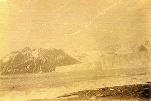 Neumayer Glacier, Cumberland West Bay, South Georgia, circa 1882
 Neumayer Glacier, Cumberland West Bay, South Georgia, circa 1882
References
- "Neumayer Glacier, South Georgia Island". Image of the Day. NASA. Retrieved 9 May 2011.
![]()
![]()
This article is issued from Wikipedia. The text is licensed under Creative Commons - Attribution - Sharealike. Additional terms may apply for the media files.