National Register of Historic Places listings in West Philadelphia
This is a list of the National Register of Historic Places listings in West Philadelphia.

This is intended to be a complete list of the properties and districts on the National Register of Historic Places in West Philadelphia, Pennsylvania, United States. The locations of National Register properties and districts for which the latitude and longitude coordinates are included below, may be seen in an online map.[1]
There are 579 properties and districts listed on the National Register in Philadelphia, including 67 National Historic Landmarks. West Philadelphia includes 65 of these properties and districts, including 5 National Historic Landmarks; the city's remaining properties and districts are listed elsewhere. Two sites are split between West Philadelphia and other parts of the city, and are thus included on multiple lists.
Current listings
| [2] | Name on the Register | Image | Date listed[3] | Location | Neighborhood[4] | Description |
|---|---|---|---|---|---|---|
| 1 | 32nd St. and Lancaster Ave. Philadelphia Armory |  32nd St. and Lancaster Ave. Philadelphia Armory |
November 14, 1991 (#91001703) |
Junction of 32nd Street and Lancaster Avenue 39°57′23″N 75°11′19″W |
University City | |
| 2 | Dimner Beeber Junior High School | 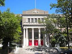 Dimner Beeber Junior High School |
November 18, 1988 (#88002244) |
5901 Malvern Avenue 39°59′11″N 75°14′34″W |
West Parkside | |
| 3 | Bell Telephone Exchange Building | 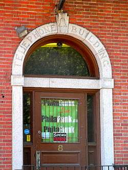 Bell Telephone Exchange Building |
March 20, 2002 (#02000227) |
8–12 North Preston Street 39°57′28″N 75°12′15″W |
Powelton Village | Telephone switching station from about 1900 to 1928 |
| 4 | Belmont Avenue Bridge in Philadelphia |  Belmont Avenue Bridge in Philadelphia |
June 22, 1988 (#88000843) |
Belmont Avenue over Ramp B 39°59′37″N 75°13′04″W |
Fairmount Park | |
| 5 | Belmont School | 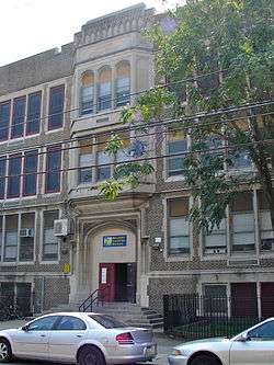 Belmont School |
November 18, 1988 (#88002245) |
4030–4060 Brown Street 39°58′00″N 75°12′18″W |
Belmont | |
| 6 | Rudolph Blankenburg School | Rudolph Blankenburg School |
November 18, 1988 (#88002248) |
4600 Girard Avenue 39°58′21″N 75°12′55″W |
Mill Creek | |
| 7 | Breslyn Apartments | 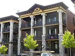 Breslyn Apartments |
November 14, 1982 (#82001544) |
4624–4642 Walnut Street, 201–213 South 47th Street 39°57′20″N 75°12′55″W |
Spruce Hill | |
| 8 | George L. Brooks School | 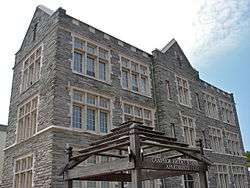 George L. Brooks School |
December 4, 1986 (#86003266) |
5629–5643 Haverford Avenue 39°58′06″N 75°14′00″W |
Haddington | |
| 9 | Lewis C. Cassidy School |  Lewis C. Cassidy School |
November 18, 1988 (#88002252) |
6523–6543 Lansdowne Avenue 39°58′30″N 75°15′03″W |
Morris Park | |
| 10 | Centennial National Bank | 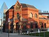 Centennial National Bank |
March 11, 1971 (#71000721) |
32nd and Market Streets 39°57′18″N 75°11′13″W |
University City | Frank Furness, architect (1875–76). |
| 11 | Chamounix | 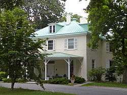 Chamounix |
April 26, 1972 (#72001146) |
West Fairmount Park on Chamounix Drive 40°00′13″N 75°11′47″W |
Fairmount Park | |
| 12 | City Line Avenue Bridge |  City Line Avenue Bridge |
June 22, 1988 (#88000802) |
City Avenue over eastern branch of Indian Creek 39°58′29″N 75°16′50″W |
Overbrook Farms | |
| 13 | Cobbs Creek Automobile Suburb Historic District | 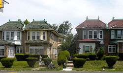 Cobbs Creek Automobile Suburb Historic District |
November 12, 1998 (#98001366) |
Roughly bounded by Cobbs Creek Parkway, Spruce Street, 62nd Street, and Angora Street 39°57′01″N 75°14′50″W |
Cobbs Creek | |
| 14 | College Hall, University of Pennsylvania | 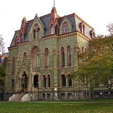 College Hall, University of Pennsylvania |
February 14, 1978 (#78002444) |
Bounded by Walnut, Spruce, 34th, and 36th Streets 39°57′05″N 75°11′38″W |
University City | Thomas W. Richards, architect (1870–72). |
| 15 | Drexel Development Historic District |  Drexel Development Historic District |
November 14, 1982 (#82001546) |
Roughly bounded by Pine, Delancey, 39th and 40th Streets 39°57′03″N 75°12′09″W |
University City | |
| 16 | Thomas Dunlap School | 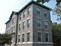 Thomas Dunlap School |
December 4, 1986 (#86003277) |
5031 Race Street 39°57′47″N 75°13′18″W |
Haddington | |
| 17 | Fairmount Park | 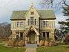 Fairmount Park |
February 7, 1972 (#72001151) |
Both banks of the Schuylkill River and the Wissahickon Creek, from Spring Garden Street to Northwestern Avenue 39°59′33″N 75°12′19″W |
Fairmount Park | Extends into North and Northwest Philadelphia |
| 18 | Furness Library |  Furness Library |
May 19, 1972 (#72001154) |
34th Street below Walnut on the University of Pennsylvania campus 39°57′06″N 75°11′34″W |
West Philadelphia | Frank Furness, architect (1888–91). |
| 19 | Garden Court Historic District |  Garden Court Historic District |
July 5, 1984 (#84003539) |
Roughly bounded by Larchwood Avenue, 46th, 50th, and Pine Streets; also 4526–4534 and 4537–4539 Osage Avenue 39°57′06″N 75°13′07″W |
Garden Court | |
| 20 | Haddington Historic District | 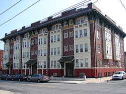 Haddington Historic District |
September 29, 1988 (#88001832) |
6000 blocks of Market, Ludlow and Chestnut Streets 39°57′41″N 75°14′31″W |
Haddington | |
| 21 | Hanson Haines House |  Hanson Haines House |
January 29, 1985 (#85000179) |
4801 Springfield Avenue 39°56′46″N 75°13′01″W |
Spruce Hill | |
| 22 | Hajoca Corporation Headquarters and Showroom | 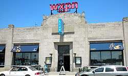 Hajoca Corporation Headquarters and Showroom |
February 27, 2003 (#03000079) |
3025 Walnut Street 39°57′08″N 75°11′06″W |
University City | |
| 23 | Hamilton Family Estate | 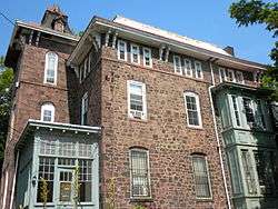 Hamilton Family Estate |
June 22, 1979 (#79002321) |
4039–4041 Baltimore Avenue and 4000–4018 Pine Street 39°57′00″N 75°12′18″W |
Spruce Hill | |
| 24 | William B. Hanna School |  William B. Hanna School |
December 4, 1986 (#86003288) |
5720–5738 Media Street 39°58′28″N 75°14′10″W |
Carroll Park | |
| 25 | Holmes Junior High School |  Holmes Junior High School |
November 18, 1988 (#88002281) |
5429–5455 Chestnut Street 39°57′35″N 75°13′51″W |
Cobbs Creek | |
| 26 | Hotel Pennsylvania |  Hotel Pennsylvania |
December 26, 2012 (#12001097) |
3900 Chestnut St. 39°57′18″N 75°12′00″W |
University City | |
| 27 | Institute of the Pennsylvania Hospital |  Institute of the Pennsylvania Hospital |
October 15, 1966 (#66000684) |
111 North 49th Street 39°57′42″N 75°13′02″W |
Mill Creek | Samuel Sloan, architect (1856–59). |
| 28 | La Blanche Apartments |  La Blanche Apartments |
March 7, 1985 (#85000470) |
5100 Walnut Street 39°57′23″N 75°13′25″W |
Walnut Hill | |
| 29 | Henry C. Lea School of Practice | 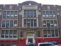 Henry C. Lea School of Practice |
November 18, 1988 (#88002291) |
242 South 47th Street 39°57′16″N 75°12′59″W |
Walnut Hill | |
| 30 | William Mann School |  William Mann School |
November 18, 1988 (#88002297) |
1835–1869 North 54th Street 39°59′08″N 75°13′53″W |
Wynnefield | |
| 31 | Memorial Hall | 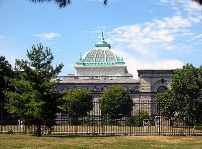 Memorial Hall |
December 8, 1976 (#76001665) |
North Concourse Drive 39°58′46″N 75°12′35″W |
Fairmount Park | Herman J. Schwarzmann, architect (1874–76). |
| 32 | Monte Vista |  Monte Vista |
March 3, 1983 (#83002275) |
917–931 North 63rd Street, 6154–6160 Oxford Street, 6151–6157 Nassau Street 39°58′46″N 75°14′44″W |
Overbrook | |
| 33 | Overbrook Farms |  Overbrook Farms |
March 21, 1985 (#85000690) |
Roughly bounded by City Line Avenue, 58th Street, Woodbine Avenue and 64th Street 39°59′17″N 75°14′55″W |
Overbrook Farms | |
| 34 | Overbrook High School | 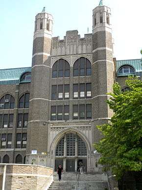 Overbrook High School |
December 4, 1986 (#86003313) |
59th and Lancaster Ave. 39°58′52″N 75°14′19″W |
Overbrook | |
| 35 | Overbrook School | 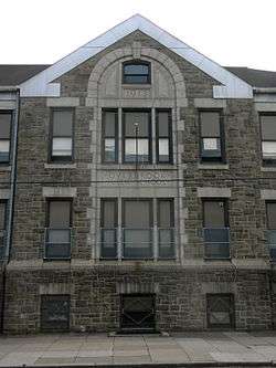 Overbrook School |
November 18, 1988 (#88002304) |
6201–6231 Lebanon Avenue 39°58′55″N 75°14′44″W |
Overbrook | |
| 36 | Parkside Historic District |  Parkside Historic District |
November 17, 1983 (#83004248) |
Bounded by Penn Central railroad tracks, 38th Street, Girard, Parkside and Belmont Avenues 39°58′24″N 75°12′23″W |
Parkside | |
| 37 | Penn Wynn House |  Penn Wynn House |
August 31, 2017 (#100001572) |
2201 Bryn Mawr Ave. 39°59′25″N 75°13′34″W |
Wynnefield | |
| 38 | Pennsylvania Railroad Freight Building |  Pennsylvania Railroad Freight Building |
October 28, 1999 (#99001291) |
3118–3198 Chestnut Street 39°57′13″N 75°11′13″W |
University City | |
| 39 | Pennsylvania Railroad Office Building | .jpg) Pennsylvania Railroad Office Building |
February 27, 2003 (#03000071) |
3175 John F. Kennedy Blvd. 39°57′22″N 75°11′15″W |
University City | |
| 40 | Pinehurst Apartments | 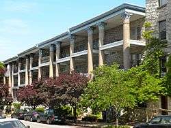 Pinehurst Apartments |
January 6, 1987 (#86003571) |
4511–4523 Pine and 324–334 South 45th Streets 39°57′07″N 75°12′46″W |
Spruce Hill | |
| 41 | Poth and Schmidt Development Houses |  Poth and Schmidt Development Houses |
April 21, 1983 (#83002276) |
3306–3316 Arch Street 39°57′27″N 75°11′24″W |
University City | |
| 42 | Frederick A. Poth Houses |  Frederick A. Poth Houses |
April 19, 1979 (#79002327) |
3301–3311, 3315 Powelton Avenue 39°57′37″N 75°11′25″W |
Powelton Village | |
| 43 | Powelton Historic District | 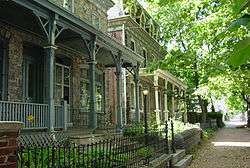 Powelton Historic District |
May 9, 1985 (#85000998) |
Roughly bounded by Brandywine Street, 32nd to 39th Streets and Lancaster Avenue 39°57′41″N 75°11′32″W |
Powelton Village | |
| 44 | The Powelton | 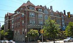 The Powelton |
December 13, 1978 (#78002452) |
3500–3520 Powelton Avenue, 214–218 35th Street, and 215–221 36th Street 39°57′35″N 75°11′25″W |
Powelton Village | |
| 45 | Protestant Episcopal Church of the Saviour | 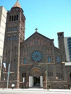 Protestant Episcopal Church of the Saviour |
August 1, 1979 (#79002328) |
Ludlow Street and 3723–3725 Chestnut Street 39°57′21″N 75°11′52″W |
University City | Charles M. Burns, architect (1889, rebuilt after 1902 fire). |
| 45 | Provident Mutual Insurance Company |  Provident Mutual Insurance Company |
December 30, 2019 (#100004809) |
4601 Market St. 39°57′32″N 75°12′51″W |
||
| 46 | Richards and Goddard Buildings | 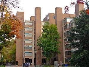 Richards and Goddard Buildings |
January 16, 2009 (#09000081) |
3700–3710 Hamilton Walk 39°56′59″N 75°11′53″W |
University City | On the University of Pennsylvania campus; Louis Kahn, architect (1957–61). |
| 47 | Paul Robeson House |  Paul Robeson House |
November 22, 2000 (#00001345) |
4951 Walnut Street 39°57′29″N 75°13′17″W |
Spruce Hill | |
| 48 | St. Anthony Hall House | 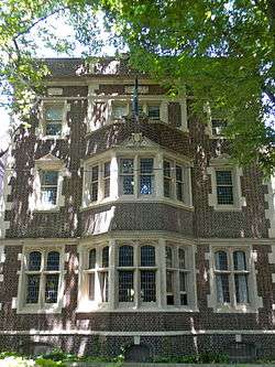 St. Anthony Hall House |
February 15, 2005 (#05000064) |
3637 Locust Walk, University of Pennsylvania 39°57′09″N 75°11′47″W |
University City | |
| 49 | Sansom Row |  Sansom Row |
December 27, 1977 (#77001190) |
3402–3436 Sansom St. 39°57′13″N 75°11′34″W |
University City | |
| 50 | John Shedwick Development Houses |  John Shedwick Development Houses |
March 10, 1982 (#82003814) |
3433–3439 Lancaster Avenue 39°57′28″N 75°11′31″W |
Powelton Village | |
| 51 | William Shoemaker Junior High School |  William Shoemaker Junior High School |
December 4, 1986 (#86003328) |
1464–1488 North 53rd Street 39°58′34″N 75°13′42″W |
Carroll Park | |
| 52 | Mayer Sulzberger Junior High School | 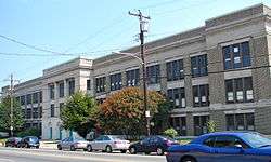 Mayer Sulzberger Junior High School |
November 18, 1988 (#88002328) |
701–741 North 48th Street 39°57′53″N 75°12′58″W |
Mill Creek | |
| 53 | Thirtieth Street Station | 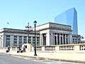 Thirtieth Street Station |
June 7, 1978 (#78002456) |
West River Drive, Market Street, 30th, and Arch Streets 39°57′20″N 75°10′55″W |
University City | Graham, Anderson, Probst & White, architects (1929–34). |
| 54 | United States Post Office-Main Branch | 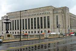 United States Post Office-Main Branch |
September 5, 2006 (#06000782) |
2970 Market Street 39°57′14″N 75°10′57″W |
University City | |
| 55 | University Avenue Bridge |  University Avenue Bridge |
May 26, 1994 (#94000515) |
South University Avenue over the Schuylkill River 39°56′34″N 75°11′49″W |
University City | Extends into South Philadelphia |
| 56 | University of Pennsylvania Campus Historic District |  University of Pennsylvania Campus Historic District |
December 28, 1978 (#78002457) |
Roughly bounded by Hamilton Walk, South, 32nd, Walnut, 36th, Spruce, and 39th Streets 39°57′08″N 75°11′40″W |
University City | |
| 57 | Walnut Park Plaza Hotel |  Walnut Park Plaza Hotel |
May 10, 2005 (#05000416) |
6232–6250 Walnut Street 39°57′33″N 75°14′49″W |
Cobbs Creek | |
| 58 | West Philadelphia High School |  West Philadelphia High School |
December 4, 1986 (#86003345) |
4700 Walnut St. 39°57′19″N 75°13′01″W |
Spruce Hill | |
| 59 | West Philadelphia Streetcar Suburb Historic District | 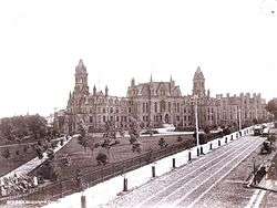 West Philadelphia Streetcar Suburb Historic District |
February 5, 1998 (#97001669) |
Roughly bounded by the University of Pennsylvania campus, Woodlands Cemetery, Poweltown Avenue, 52nd Street, and Woodland Avenue 39°57′01″N 75°12′45″W |
Spruce Hill | Boundary increase approved April 17, 2018. |
| 60 | WFIL Studio |  WFIL Studio |
July 28, 1986 (#86002092) |
4548 Market Street 39°57′30″N 75°12′45″W |
Spruce Hill | |
| 61 | Wharton Street Memorial Methodist Episcopal Church and Sunday School |  Wharton Street Memorial Methodist Episcopal Church and Sunday School |
December 2, 2019 (#100004703) |
5337 Catharine St. 39°56′58″N 75°13′51″W |
||
| 62 | Woodland Terrace |  Woodland Terrace |
March 16, 1972 (#72001176) |
501–519, 500–520 Woodland Terrace 39°56′58″N 75°12′17″W |
University City | Samuel Sloan, architect. |
| 63 | The Woodlands | 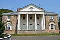 The Woodlands |
December 24, 1967 (#67000022) |
40th Street and Woodland Avenue 39°56′50″N 75°12′10″W |
University City | Built ca. 1742, expanded 1787-90. |
| 64 | Wynnestay | .jpg) Wynnestay |
December 30, 2008 (#08001270) |
5125 Woodbine Avenue 39°59′38″N 75°13′49″W |
Wynnefield | Built 1689, expanded 1700. |
See also
| Wikimedia Commons has media related to National Register of Historic Places in West Philadelphia. |
- List of National Historic Landmarks in Philadelphia
- National Register of Historic Places listings in Philadelphia, Pennsylvania
References
- The latitude and longitude information provided in this table was derived originally from the National Register Information System, which has been found to be fairly accurate for about 99% of listings. Some locations in this table may have been corrected to current GPS standards.
- Numbers represent an ordering by significant words. Various colorings, defined here, differentiate National Historic Landmarks and historic districts from other NRHP buildings, structures, sites or objects.
- The eight-digit number below each date is the number assigned to each location in the National Register Information System database, which can be viewed by clicking the number.
- "The Political and Community Service Boundaries of Philadelphia" (PDF). Philadelphia City Planning Commission. June 2004. Archived from the original (PDF) on 2011-03-07.
| Topics |  | |
|---|---|---|
| Lists by county |
| |
| Lists by city |
| |
| Other lists | ||
| ||