National Register of Historic Places listings in Clearfield County, Pennsylvania
This is a list of the National Register of Historic Places listings in Clearfield County, Pennsylvania.
Location of Clearfield County in Pennsylvania
This is intended to be a complete list of the properties and districts on the National Register of Historic Places in Clearfield County, Pennsylvania, United States. The locations of National Register properties and districts for which the latitude and longitude coordinates are included below, may be seen in a map.[1]
There are 20 properties and districts listed on the National Register in the county. Another property was once listed but has been removed.
- This National Park Service list is complete through NPS recent listings posted June 19, 2020.[2]
Current listings
| [3] | Name on the Register | Image | Date listed[4] | Location | City or town | Description |
|---|---|---|---|---|---|---|
| 1 | Bridge in Greenwood Township |  Bridge in Greenwood Township |
June 22, 1988 (#88000846) |
Legislative Route 17026 over the West Branch of the Susquehanna River 40°54′39″N 78°38′51″W |
Greenwood Township | Pratt through truss bridge built in 1892. Now torn down. |
| 2 | Bridge in Westover Borough | 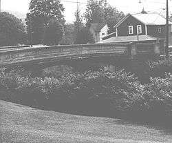 Bridge in Westover Borough |
June 22, 1988 (#88000736) |
Legislative Route 17003/Township Route 185 over Chest Creek 40°45′09″N 78°40′03″W |
Westover | Open-spandrel arch bridge constructed in 1917. |
| 3 | Clearfield Armory | Clearfield Armory |
December 22, 1989 (#89002072) |
Coal Hill Road 41°00′44″N 78°27′45″W |
Lawrence Township | Brick armory dating to 1938. |
| 4 | Clearfield County Courthouse | Clearfield County Courthouse |
April 27, 1979 (#79002210) |
2nd and Market Streets 41°01′20″N 78°26′16″W |
Clearfield | County courthouse building constructed in 1860. |
| 5 | Coalport Historic District |  Coalport Historic District |
April 29, 1999 (#99000517) |
Along Main Street, roughly from Mill to Walnut Streets 40°44′54″N 78°32′07″W |
Coalport | |
| 6 | Commercial Hotel |  Commercial Hotel |
November 13, 1985 (#85003507) |
Long and Brady Avenues 41°07′07″N 78°45′44″W |
DuBois | Four story brick structure dating back to 1889; includes Harris-DuBois Theater. |
| 7 | Dimeling Hotel | 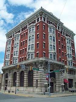 Dimeling Hotel |
April 10, 1980 (#80003474) |
2nd and Market Streets 41°01′20″N 78°26′19″W |
Clearfield | Seven story former hotel constructed in 1904-1905. |
| 8 | DuBois Historic District |  DuBois Historic District |
October 24, 1997 (#97001254) |
Roughly along North and South Brady Streets, and East and West Long Avenues 41°07′09″N 78°45′47″W |
Dubois | |
| 9 | S.B. Elliott State Park Day Use District |  S.B. Elliott State Park Day Use District |
February 11, 1987 (#87000023) |
9 miles (14 km) north of Clearfield on Pennsylvania Route 153 41°06′47″N 78°31′36″W |
Pine Township | |
| 10 | S.B. Elliott State Park Family Cabin District |  S.B. Elliott State Park Family Cabin District |
February 11, 1987 (#87000024) |
9 miles (14 km) north of Clearfield on Pennsylvania Route 153 41°06′39″N 78°31′23″W |
Pine Township | |
| 11 | Hogback Bridge | 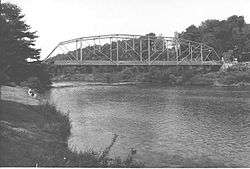 Hogback Bridge |
June 22, 1988 (#88000848) |
Legislative Route 869 over the West Branch of the Susquehanna River 40°58′25″N 78°29′26″W |
Lawrence Township | Pennsylvania (petit) truss bridge built in 1893. Modern bridge replaced the historic structure, which is now gone. |
| 12 | Irvin-Patchin House | 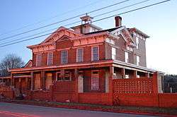 Irvin-Patchin House |
June 19, 1979 (#79002209) |
Main Street 40°48′59″N 78°47′13″W |
Burnside | Brick dwelling constructed initially in 1850 by early settler William Irvin. |
| 13 | McGees Mills Covered Bridge | 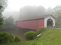 McGees Mills Covered Bridge |
April 17, 1980 (#80003475) |
West of Mahaffey 40°52′48″N 78°45′55″W |
Bell Township | A 109-foot (33 m) covered bridge built in 1873. |
| 14 | Thomas Murray House | Thomas Murray House |
October 25, 1979 (#79002211) |
120 S. 2nd St. 41°01′12″N 78°26′17″W |
Clearfield | Italianate style brick dwelling constructed in 1876. |
| 15 | Old Town Historic District | Old Town Historic District |
May 15, 1979 (#79002212) |
Irregular pattern along Front Street 41°01′20″N 78°26′24″W |
Clearfield | |
| 16 | Parker Dam State Park Family Cabin District | 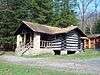 Parker Dam State Park Family Cabin District |
February 11, 1987 (#87000043) |
5 miles (8.0 km) south of Penfield off Pennsylvania Route 153 41°11′49″N 78°30′56″W |
Huston Township | |
| 17 | Parker Dam State Park-Octagonal Lodge |  Parker Dam State Park-Octagonal Lodge |
May 11, 1987 (#87000044) |
5 miles (8.0 km) south of Penfield off Pennsylvania Route 153 41°12′32″N 78°30′11″W |
Huston Township | |
| 18 | Parker Dam State Park-Parker Dam District |  Parker Dam State Park-Parker Dam District |
February 11, 1987 (#87000049) |
5 miles (8.0 km) south of Penfield off Pennsylvania Route 153 41°11′54″N 78°30′29″W |
Huston Township | |
| 19 | Joseph F. and Anna B. Schrot Farm |  Joseph F. and Anna B. Schrot Farm |
September 8, 2011 (#11000643) |
880 Carbon Mine Road 40°58′57″N 78°29′15″W |
Lawrence Township | |
| 20 | St. Severin's Old Log Church | 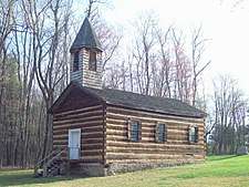 St. Severin's Old Log Church |
June 5, 1975 (#75001633) |
West of Cooper Settlement off Pennsylvania Route 53 41°01′54″N 78°06′38″W |
Cooper Township | Roman Catholic church built by German settlers in about 1851. |
Former listing
| [3] | Name on the Register | Image | Date listed | Date removed | Location | City or town | Summary |
|---|---|---|---|---|---|---|---|
| 1 | DuBois Mansion |  DuBois Mansion |
April 16, 1975 (#75001634) | Unknown | College Pl. |
DuBois | The DuBois Mansion existed from 1875-1978. The originally Italianate building was remodeled to Tudor in 1902 as shown in this image. After 1934 it became part of the Penn State Campus. A frozen and burst water pipe damaged the building heavily and in 1978 - despite appeals and fundraising - the building was demolished. Currently the site of DuBois campus of Penn State University and the DuBois Area High School. |
See also
| Wikimedia Commons has media related to National Register of Historic Places in Clearfield County, Pennsylvania. |
References
- The latitude and longitude information provided in this table was derived originally from the National Register Information System, which has been found to be fairly accurate for about 99% of listings. Some locations in this table may have been corrected to current GPS standards.
- "National Register of Historic Places: Weekly List Actions". National Park Service, United States Department of the Interior. Retrieved on June 19, 2020.
- Numbers represent an ordering by significant words. Various colorings, defined here, differentiate National Historic Landmarks and historic districts from other NRHP buildings, structures, sites or objects.
- The eight-digit number below each date is the number assigned to each location in the National Register Information System database, which can be viewed by clicking the number.
| Topics | 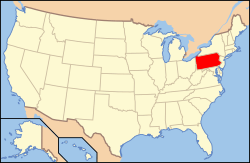 | |
|---|---|---|
| Lists by county |
| |
| Lists by city |
| |
| Other lists | ||
| ||
Municipalities and communities of Clearfield County, Pennsylvania, United States | ||
|---|---|---|
| City | ||
| Boroughs | ||
| Townships | ||
| CDPs | ||
| Unincorporated communities | ||
| Footnotes | ‡This populated place also has portions in an adjacent county or counties | |
This article is issued from Wikipedia. The text is licensed under Creative Commons - Attribution - Sharealike. Additional terms may apply for the media files.