National Register of Historic Places listings in Luzerne County, Pennsylvania
This is a list of the National Register of Historic Places listings in Luzerne County, Pennsylvania.

Location of Luzerne County in Pennsylvania
This is intended to be a complete list of the properties and districts on the National Register of Historic Places in Luzerne County, Pennsylvania, United States. The locations of National Register properties and districts for which the latitude and longitude coordinates are included below, may be seen in a map.[1]
There are 36 properties and districts listed on the National Register in the county.
- This National Park Service list is complete through NPS recent listings posted June 19, 2020.[2]
Current listings
| [3] | Name on the Register | Image | Date listed[4] | Location | City or town | Description |
|---|---|---|---|---|---|---|
| 1 | Ashley Planes |  Ashley Planes |
January 25, 1980 (#80003562) |
Off Pennsylvania Route 309 41°11′26″N 75°54′37″W |
Fairview and Hanover Townships | |
| 2 | Bear Creek Village Historic District | 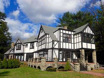 Bear Creek Village Historic District |
October 28, 1999 (#99001287) |
Pennsylvania Route 115 at Bear Creek Dam 41°11′00″N 75°45′20″W |
Bear Creek Village | |
| 3 | Bittenbender Covered Bridge |  Bittenbender Covered Bridge |
December 1, 1980 (#80003563) |
South of Huntington Mills off Legislative Route 40076 41°10′51″N 76°13′30″W |
Huntington Township | Collapsed in 2006 |
| 4 | Bridge in City of Wilkes-Barre | 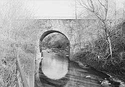 Bridge in City of Wilkes-Barre |
June 22, 1988 (#88000828) |
Legislative Route 5 over Mill Creek 41°15′36″N 75°52′02″W |
Wilkes-Barre | |
| 5 | Catlin Hall, Wilkes College |  Catlin Hall, Wilkes College |
March 16, 1972 (#72001132) |
92 South River Street 41°14′48″N 75°53′12″W |
Wilkes-Barre | |
| 6 | Central Railroad of New Jersey Station |  Central Railroad of New Jersey Station |
May 12, 1975 (#75001652) |
31–35 South Baltimore Street 41°14′31″N 75°52′47″W |
Wilkes-Barre | |
| 7 | Comerford Theater |  Comerford Theater |
December 3, 1980 (#80003564) |
71 Public Square 41°14′41″N 75°52′55″W |
Wilkes-Barre | |
| 8 | Denison House | 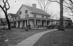 Denison House |
December 2, 1970 (#70000550) |
35 Denison Street 41°17′57″N 75°51′46″W |
Forty Fort | |
| 9 | Eckley Historic District | 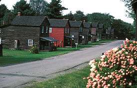 Eckley Historic District |
October 26, 1971 (#71000710) |
Both sides of Main Street through Eckley 40°59′36″N 75°51′45″W |
Foster Township | |
| 10 | Benjamin Evans House |  Benjamin Evans House |
August 25, 1983 (#83002260) |
Off Pennsylvania Route 93 south of Nescopeck 41°02′36″N 76°13′19″W |
Nescopeck Township | |
| 11 | Forty Fort Meetinghouse |  Forty Fort Meetinghouse |
November 3, 1988 (#88002373) |
River Street and Wyoming Avenue 41°17′04″N 75°52′18″W |
Forty Fort | |
| 12 | George W. Guthrie School |  George W. Guthrie School |
June 27, 1980 (#80003565) |
643 North Washington Street 41°15′22″N 75°51′47″W |
Wilkes-Barre | |
| 13 | Hazelton High School |  Hazelton High School |
April 16, 2012 (#12000222) |
700 N. Wyoming St. 40°57′59″N 75°58′21″W |
Hazleton | Educational Resources of Pennsylvania Multiple Property Submission |
| 14 | Hotel Altamont | 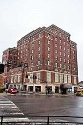 Hotel Altamont |
December 29, 2014 (#14001101) |
145 W. Broad St. 40°57′17″N 75°58′36″W |
Hazleton | |
| 15 | Kingston Armory |  Kingston Armory |
December 21, 1989 (#89002084) |
280 Market Street 41°15′10″N 75°53′31″W |
Kingston | |
| 16 | Luzerne County Courthouse | 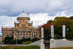 Luzerne County Courthouse |
September 4, 1980 (#80003566) |
North River Street 41°15′05″N 75°52′46″W |
Wilkes-Barre | |
| 17 | Luzerne County Fresh Air Camp | 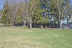 Luzerne County Fresh Air Camp |
February 20, 2004 (#04000064) |
Middle Road, approximately 0.25 miles (0.40 km) northeast of the junction of Middle Road and Pennsylvania Route 3021 41°00′44″N 75°59′44″W |
Butler Township | |
| 18 | Luzerne Presbyterial Institute |  Luzerne Presbyterial Institute |
September 7, 1979 (#79002293) |
Institute Street 41°18′39″N 75°50′29″W |
Wyoming | |
| 19 | Market Street Bridge |  Market Street Bridge |
June 22, 1988 (#88000873) |
Market Street/Legislative Route 11 over the Susquehanna River 41°14′55″N 75°53′07″W |
Kingston and Wilkes-Barre | |
| 20 | Markle Banking & Trust Company Building | 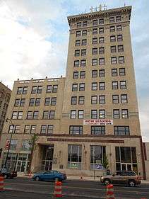 Markle Banking & Trust Company Building |
March 28, 1996 (#96000322) |
8 West Broad Street 40°57′14″N 75°58′29″W |
Hazleton | |
| 21 | McClintock Hall | 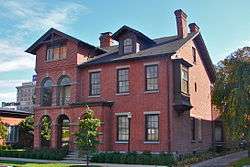 McClintock Hall |
March 16, 1972 (#72001133) |
44 South River Street 41°14′52″N 75°53′05″W |
Wilkes-Barre | |
| 22 | Memorial Presbyterian Church |  Memorial Presbyterian Church |
September 18, 2017 (#100001636) |
29 W. North Street 41°15′01″N 75°52′34″W |
Wilkes-Barre | |
| 23 | Israel Platt Pardee Mansion |  Israel Platt Pardee Mansion |
January 12, 1984 (#84003487) |
235 North Laurel Street and 28 Aspen Street 40°57′36″N 75°58′22″W |
Hazleton | Designed by architect George Franklin Barber |
| 24 | River Street Historic District |  River Street Historic District |
September 10, 1985 (#85002328) |
Franklin, River, West River, West Jackson, West Union, West Market, West Northampton, West South and West Ross Streets and Barnum Place 41°14′49″N 75°53′09″W |
Wilkes-Barre | |
| 25 | St. Gabriel's Catholic Parish Complex | 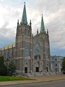 St. Gabriel's Catholic Parish Complex |
August 22, 2002 (#02000889) |
122–142 South Wyoming Street 40°56′55″N 75°58′20″W |
Hazleton | |
| 26 | St. John the Evangelist Roman Catholic Church and School Building |  St. John the Evangelist Roman Catholic Church and School Building |
July 30, 2003 (#03000721) |
419 North Main Street 41°15′29″N 75°52′03″W |
Wilkes-Barre | |
| 27 | St. Stanislaus Institute | 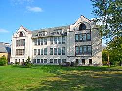 St. Stanislaus Institute |
December 30, 2008 (#08001267) |
141 Old Newport Street 41°11′32″N 76°01′03″W |
Newport Township | |
| 28 | George W. Search House | 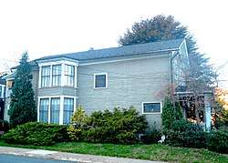 George W. Search House |
July 10, 2009 (#09000387) |
56 South Main Street 41°09′03″N 76°09′03″W |
Shickshinny | |
| 29 | Stegmaier Brewery |  Stegmaier Brewery |
May 30, 1979 (#79002292) |
Roughly bounded by Coal, Welles, Market, Lincoln and Baltimore Streets 41°14′32″N 75°52′36″W |
Wilkes-Barre | |
| 30 | Stoddartsville Historic District |  Stoddartsville Historic District |
November 12, 1998 (#98001373) |
South side of Pennsylvania Route 115 at the Lehigh River in Stoddartsville 41°07′47″N 75°37′42″W |
Buck Township | |
| 31 | Swetland Homestead | 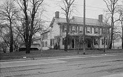 Swetland Homestead |
December 13, 1978 (#78002427) |
855 Wyoming Avenue 41°18′06″N 75°51′10″W |
Wyoming | |
| 32 | Weiss Hall |  Weiss Hall |
November 27, 1972 (#72001134) |
98 South River Street 41°14′47″N 75°53′12″W |
Wilkes-Barre | |
| 33 | West End Wheelmen's Club | 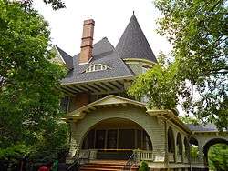 West End Wheelmen's Club |
May 30, 1997 (#97000521) |
439 South Franklin Street 41°14′24″N 75°53′47″W |
Wilkes-Barre | |
| 34 | Wilkes-Barre Silk Company Mill | November 25, 2019 (#100004666) |
92 S. Empire St. 41°14′03″N 75°52′21″W |
Wilkes-Barre | ||
| 35 | Wyoming Monument | 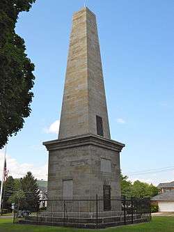 Wyoming Monument |
May 13, 2002 (#02000509) |
U.S. Route 11, Wyoming Avenue and Susquehanna Street 41°18′13″N 75°50′45″W |
Wyoming | |
| 36 | Wyoming Seminary | 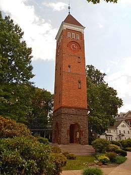 Wyoming Seminary |
August 6, 1979 (#79002291) |
Sprague Avenue 41°15′48″N 75°53′54″W |
Kingston |
See also
| Wikimedia Commons has media related to National Register of Historic Places in Luzerne County, Pennsylvania. |
References
- The latitude and longitude information provided in this table was derived originally from the National Register Information System, which has been found to be fairly accurate for about 99% of listings. Some locations in this table may have been corrected to current GPS standards.
- "National Register of Historic Places: Weekly List Actions". National Park Service, United States Department of the Interior. Retrieved on June 19, 2020.
- Numbers represent an ordering by significant words. Various colorings, defined here, differentiate National Historic Landmarks and historic districts from other NRHP buildings, structures, sites or objects.
- The eight-digit number below each date is the number assigned to each location in the National Register Information System database, which can be viewed by clicking the number.
| Topics |  | |
|---|---|---|
| Lists by county |
| |
| Lists by city |
| |
| Other lists | ||
| ||
Municipalities and communities of Luzerne County, Pennsylvania, United States | ||
|---|---|---|
| Cities | | |
| Boroughs |
| |
| Townships | ||
| CDPs | ||
| Unincorporated communities |
| |
| Footnotes | ‡This populated place also has portions in an adjacent county or counties | |
This article is issued from Wikipedia. The text is licensed under Creative Commons - Attribution - Sharealike. Additional terms may apply for the media files.