South Philadelphia Sports Complex
The South Philadelphia Sports Complex is the current home of Philadelphia's professional sports teams, located in the South Philadelphia section of Philadelphia, Pennsylvania. It is the site of the Wells Fargo Center, Lincoln Financial Field, Citizens Bank Park, and the retail/entertainment center Xfinity Live!.
South Philadelphia Sports Complex | |
|---|---|
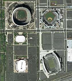 The South Philadelphia Sports Complex as it existed in 2003–2004. Clockwise from top right: Citizens Bank Park, Lincoln Financial Field, Wells Fargo Center (formerly the site of John F. Kennedy Stadium), the Spectrum (razed in 2011), and Veterans Stadium (imploded in 2004). Interstate 95 can be seen running through the bottom right corner of the photo. | |
 South Philadelphia Sports Complex | |
| Coordinates: 39°54′4″N 75°10′19″W | |
| Country | |
| State | Pennsylvania |
| County | Philadelphia County |
| City | Philadelphia |
| Area code(s) | 215, 267 and 445 |
History
The South Philadelphia Sports Complex was also once home to John F. Kennedy Stadium, Veterans Stadium and the Spectrum. Prior to its development, it was a shanty town known as "The Neck" of the undeveloped League Island area, formerly Passyunk Township. Oregon Avenue was the southern border end of the city up to the 1920s.
In 1926 the City selected the area south of Oregon Avenue for the 1926 Sesquicentennial International Exposition and developed the large river delta land south of Oregon Avenue. South Broad Street was a grand European-styled boulevard surrounded by massive exhibit buildings and structures that were to be a testament to American science, culture, and progress for the future. Following the close of the celebration of these 150 years of American Independence on the Avenue of the Colonies of South Broad Street came quick total demolition except of the stadium.
Prior to building Veterans Stadium across Packer Avenue north of JFK Stadium was family entertainment of a bowling alley, and a drive-in theater that was a venue created by Camden, New Jersey, chemical company magnate Richard M. Hollingshead, Jr., whose family owned and operated the R.M. Hollingshead Corporation chemical plant in Camden and that peaked in popularity in the 1950s and 1960s.

Current facilities
- Wells Fargo Center: The Wells Fargo Center opened in 1996 and is home to the Philadelphia Flyers (NHL), Philadelphia 76ers (NBA), and the Philadelphia Wings (National Lacrosse League). The Villanova Wildcats (NCAA basketball) play select games at the Wells Fargo Center.
- Lincoln Financial Field: Known as "The Linc", Lincoln Financial Field opened in 2003 and is home to the NFL's Philadelphia Eagles and the Temple Owls football team (NCAA).
- Citizens Bank Park: This stadium opened in 2004 and is home to MLB's Philadelphia Phillies.
- Xfinity Live!: a retail and entertainment center built just east of the site of the Spectrum at 11th Street.
Planned facilities
Comcast Spectacor has announced plans to build a esports venue, the Fusion Arena, to support the Philadelphia Fusion in the Overwatch League. The 3,500-capacity arena will be built adjacent to the Xfinity Live! building. The arena is estimated to cost US$50 million and will be completed by early 2021. Outside of the Overwatch League games, the venue will be used for other smaller events.[1]
Former facilities
- John F. Kennedy Stadium: JFK Stadium opened in 1926 as Sesquicentennial Stadium for the Sesquicentennial Exposition, and was renamed Philadelphia Municipal Stadium following the Exposition. The name was again changed in 1964 in honor of President John F. Kennedy, who had been assassinated on November 22, 1963. JFK Stadium was condemned in 1989 and demolished in 1992. JFK was home to the Eagles, the Philadelphia Quakers of the first American Football League, the Philadelphia Bell of the World Football League, and 42 Army–Navy Games. It was also one of the host sites for the original Live Aid concert in 1985, and the Jacksons Victory Tour in September 1984.
- The Spectrum: The Spectrum (formerly the CoreStates Spectrum, First Union Spectrum, and Wachovia Spectrum) opened in 1967 and was the home of the Flyers, 76ers and Philadelphia Wings until 1996. From 1996 to 2009 the Spectrum was the home of the Philadelphia Phantoms (AHL), Philadelphia KiXX (NISL), and served as an alternate home for the Soul. The Spectrum hosted six Stanley Cup Finals, four NBA Finals, two NHL All-Star Games, two NBA All-Star Games and two NCAA Final Fours. The Spectrum closed on October 31, 2009, following Pearl Jam's performance at the last show of a four-night concert set. Demolition of the Spectrum began in November 2010 and was completed in April 2011.
- Veterans Stadium: also known as "The Vet", opened in 1971, closed in 2003, and was imploded on March 21, 2004. The Vet was home of the Eagles and the Phillies. The Vet also hosted three World Series (1980, 1983 and 1993), two Major League Baseball All-Star Games (1976 and 1996) and 17 Army–Navy Games.
- Aquarama Aquarium Theater of the Sea: existed between 1962 and 1969. It was located at 3200 South Broad Street bordering the Packer Park residential neighborhood in South Philadelphia. It was the successor to the Philadelphia Aquarium, established in the City of Philadelphia and built in 1911 along the Schuylkill River northwest of the Parkway's Art Museum in Center City. The relocated aquarium was augmented by elements of family fun exhibits and aquatic shows. The new public spaces hosted popular teen dances, and became an identifiable part of South Philadelphia's pop culture scene during the 1950s and 1960s with disc jockeys like Ed Hurst, Jerry Blavat and Dick Clark of American Bandstand garnering significant attention. After its demolition, movie theater and fast-food hamburger chain, the "Steer-in", were built on the site, which would be demolished in the 1990s to make way for new residential and commercial development.
Transportation
NRG station on SEPTA's Broad Street Line is within walking distance of the three venues in the area. It was once known as Pattison Station until it was renamed AT&T Station under a naming rights agreement in 2010; the naming rights passed to NRG in 2018. NRG station is served by local trains along with special Sports Express trains making limited stops along the line before and after events at the Sports Complex.[2] SEPTA City Bus routes 4 and 17 provide service to the Sports Complex.[3]
Stadiums
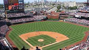 Citizens Bank Park (2004–present)
.JPG) Lincoln Financial Field (2003–present)
Lincoln Financial Field (2003–present).jpg) Wells Fargo Center (1996–present) (Then-Wachovia Center)
Wells Fargo Center (1996–present) (Then-Wachovia Center)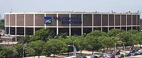 The Spectrum (1967–2011)
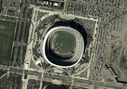 Veterans Stadium (1971–2004)
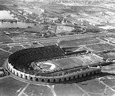 John F. Kennedy Stadium (1926–1992)
References
- Sinclair, Brendan (March 25, 2019). "Philadelphia Overwatch team getting $50m arena". GamesIndustry.biz. Retrieved March 25, 2019.
- "Broad Street Line Sports Express". SEPTA. Retrieved October 3, 2017.
- SEPTA Official Philadelphia Transit & Street Map (PDF) (Map). SEPTA. Retrieved November 25, 2018.
External links
- Morley, Christopher (1920). "Stonehouse Lane and the Neck". Travels in Philadelphia. Philadelphia: David McKay Company, Publishers. Retrieved 2009-11-02.
- Shpigel, Ben (2009-11-01). "In Gritty South Philly, a Piece of Sacred Ground". New York Times.
| |
| Franchise | |
| Arenas |
|
| Personnel |
|
| G League affiliate | |
| Retired numbers | |
| NBA Championships | |
| Rivalries | |
| Culture and lore |
|
| |
| |
| Franchise | |
| History | |
| Personnel |
|
| Arenas | |
| Rivalries | |
| Affiliates | |
| Media |
|
| Culture and lore |
|
| |