National Register of Historic Places listings in Cambria County, Pennsylvania
This is a list of the National Register of Historic Places listings in Cambria County, Pennsylvania.
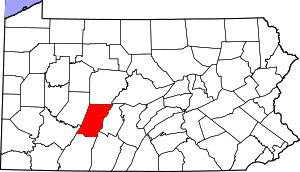
Location of Cambria County in Pennsylvania
This is intended to be a complete list of the properties and districts on National Register of Historic Places in the Cambria County, Pennsylvania. The locations of National Register properties and districts for which the latitude and longitude coordinates are included below, may be seen in a map.[1]
There are 31 properties and districts listed on the National Register in the county. Two sites are further designated as National Historic Landmarks and another is designated as a National Memorial.
- This National Park Service list is complete through NPS recent listings posted June 19, 2020.[2]
Current listings
| [3] | Name on the Register | Image | Date listed[4] | Location | Municipality | Description |
|---|---|---|---|---|---|---|
| 1 | Allegheny Portage Railroad National Historic Site | 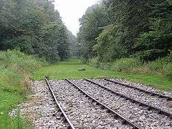 Allegheny Portage Railroad National Historic Site |
October 15, 1966 (#66000648) |
U.S. Route 22 40°24′47″N 78°27′37″W |
Conemaugh and Cresson Townships | Extends into Allegheny Township in Blair County |
| 2 | Berwind-White Mine 40 Historic District |  Berwind-White Mine 40 Historic District |
April 28, 1992 (#92000392) |
Roughly bounded by the boney pile, the Eureka No. 40 mine site, the Scalp Level borough line, and the Berwind-White Farmstead 40°15′13″N 78°50′21″W |
Richland Township and Scalp Level | Mining patch town. |
| 3 | Bridge in Johnstown City | 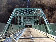 Bridge in Johnstown City |
June 22, 1988 (#88000805) |
State Route 3022 spur over the Stonycreek River 40°19′33″N 78°55′33″W |
Johnstown | |
| 4 | Bridge in Portage Township | 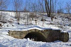 Bridge in Portage Township |
June 22, 1988 (#88000782) |
Pennsylvania Route 53 over Bens Creek 40°24′08″N 78°38′24″W |
Portage Township | |
| 5 | A.W. Buck House |  A.W. Buck House |
May 12, 1995 (#95000521) |
615 North Center Street 40°29′22″N 78°43′31″W |
Ebensburg | |
| 6 | Cambria City Historic District | 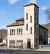 Cambria City Historic District |
November 14, 1991 (#91001706) |
Roughly bounded by Broad Street, Tenth Avenue, and the Conemaugh River 40°20′27″N 78°55′46″W |
Johnstown | |
| 7 | Cambria County Courthouse | 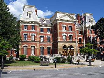 Cambria County Courthouse |
June 30, 1980 (#80003449) |
Center Street 40°29′01″N 78°43′29″W |
Ebensburg | |
| 8 | Cambria County Jail |  Cambria County Jail |
June 30, 1980 (#80003450) |
North Center and Sample Streets 40°29′11″N 78°43′34″W |
Ebensburg | |
| 9 | Cambria Iron Company |  Cambria Iron Company |
June 22, 1989 (#89001101) |
Five industrial complexes along the Conemaugh River in or near Johnstown 40°19′42″N 78°55′13″W |
Johnstown | |
| 10 | Cambria Public Library Building | 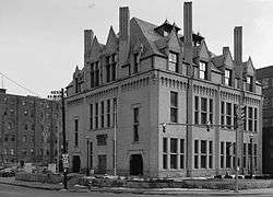 Cambria Public Library Building |
June 19, 1972 (#72001100) |
304 Washington Street 40°19′40″N 78°55′15″W |
Johnstown | |
| 11 | Colver Historic District |  Colver Historic District |
June 3, 1994 (#94000521) |
Roughly bounded by Ninth Avenue, the Ebensburg Coal Company Power Building, and Bakerville, in Colver 40°32′36″N 78°47′46″W |
Barr, Blacklick, and Cambria Townships | |
| 12 | Downtown Johnstown Historic District |  Downtown Johnstown Historic District |
August 7, 1992 (#92000941) |
Bounded by Washington, Clinton, Bedford, Vine, Market, Locust, and Walnut Streets 40°19′30″N 78°55′07″W |
Johnstown | |
| 13 | Ebensburg Historic District | 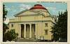 Ebensburg Historic District |
September 10, 2019 (#100004163) |
Bounded Roughly by Highland Ave., West St., Sugar St., and Triumph St. 40°29′10″N 78°43′30″W |
Ebensburg | |
| 14 | Eliza Furnace |  Eliza Furnace |
September 6, 1991 (#91001138) |
Lower Main Street 40°29′03″N 78°55′20″W |
Vintondale | Extends into Indiana County |
| 15 | Grand Army of the Republic Hall | _Front.jpg) Grand Army of the Republic Hall |
April 17, 1980 (#80003451) |
132 Park Place 40°19′34″N 78°55′07″W |
Johnstown | |
| 16 | Johnstown Flood National Memorial |  Johnstown Flood National Memorial |
October 15, 1966 (#66000656) |
Junction of U.S. Route 219 and Pennsylvania Route 869, St. Michael-Sidman 40°20′46″N 78°46′14″W |
Adams and Croyle Townships | |
| 17 | Johnstown Inclined Railway | 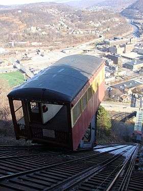 Johnstown Inclined Railway |
June 18, 1973 (#73001597) |
Between Johns Street and Edgehill Drive 40°19′32″N 78°55′43″W |
Johnstown | |
| 18 | Benjamin F. Jones Cottage |  Benjamin F. Jones Cottage |
February 24, 1995 (#95000125) |
Third Street 40°27′27″N 78°35′30″W |
Cresson Township | |
| 19 | Lilly Bridge |  Lilly Bridge |
June 22, 1988 (#88000785) |
Pennsylvania Route 53 over Burgoon Run 40°25′26″N 78°37′08″W |
Lilly | |
| 20 | Minersville Historic District | 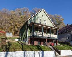 Minersville Historic District |
April 27, 1995 (#95000522) |
Roughly along Connelly Avenue, Honan Avenue, Garvey Place, and Iron Street 40°20′34″N 78°55′35″W |
Johnstown and West Taylor Township | |
| 21 | Moxham Historic District | .jpg) Moxham Historic District |
March 12, 1999 (#99000324) |
Roughly bounded by Dupont Street, Linden Avenue, Village Street, and Park and Coleman Avenues 40°17′52″N 78°54′30″W |
Johnstown | |
| 22 | Nathan's Department Store |  Nathan's Department Store |
August 10, 1979 (#79002178) |
426–432 Main St. 40°19′31″N 78°55′08″W |
Johnstown | |
| 23 | Philip Noon House |  Philip Noon House |
August 23, 1984 (#84003179) |
114 East High Street 40°29′05″N 78°43′29″W |
Ebensburg | |
| 24 | Old Conemaugh Borough Historic District | 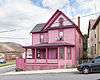 Old Conemaugh Borough Historic District |
November 7, 1995 (#95001253) |
Roughly bounded by Railroad, Adams, and Steel Streets, and Church Avenue 40°19′37″N 78°54′39″W |
Johnstown | |
| 25 | Patton Historic District | 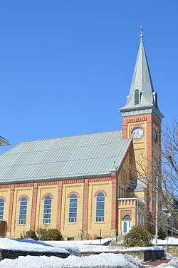 Patton Historic District |
June 28, 1996 (#96000714) |
Roughly bounded by 5th, Beech, 6th, and Palmer Avenues and Terra Cotta Street 40°38′10″N 78°39′04″W |
Patton | |
| 26 | Portage Historic District | 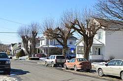 Portage Historic District |
July 21, 1995 (#95000890) |
Roughly bounded by North Railroad Avenue, Prospect Street, Johnson Avenue, and Vine Street 40°23′07″N 78°40′23″W |
Portage | |
| 27 | Revloc Historic District | 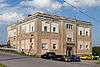 Revloc Historic District |
May 11, 1995 (#95000520) |
Roughly bounded by Highland Avenue, Fourth Street, Penn Avenue, and Eighth Street in Revloc 40°29′27″N 78°45′52″W |
Cambria Township | |
| 28 | South Fork Fishing and Hunting Club Historic District |  South Fork Fishing and Hunting Club Historic District |
July 31, 1986 (#86002091) |
Roughly bounded by Fortieth, Main, and Lake Streets 40°20′17″N 78°46′24″W |
Adams Township | |
| 29 | Staple Bend Tunnel | Staple Bend Tunnel |
April 19, 1994 (#94001187) |
Junction of Legislative Route 3035 and Mineral Point 40°21′33″N 78°51′19″W |
Conemaugh Township | |
| 30 | Westmont Historic District | 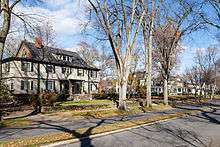 Westmont Historic District |
February 24, 1995 (#95000131) |
Roughly bounded by Clarion Street, Edgehill Drive, Blair and Wayne Streets, Diamond Boulevard, and Stackhouse Park 40°19′20″N 78°56′19″W |
Westmont | |
| 31 | Windber Historic District | 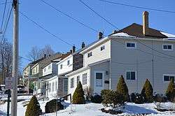 Windber Historic District |
November 14, 1991 (#91001705) |
Roughly bounded by the borough line, Cambria Avenue, 28th Street, and Big Paint Creek 40°14′10″N 78°49′55″W |
Scalp Level | Extends into Somerset County |
See also
| Wikimedia Commons has media related to National Register of Historic Places in Cambria County, Pennsylvania. |
References
- The latitude and longitude information provided in this table was derived originally from the National Register Information System, which has been found to be fairly accurate for about 99% of listings. Some locations in this table may have been corrected to current GPS standards.
- "National Register of Historic Places: Weekly List Actions". National Park Service, United States Department of the Interior. Retrieved on June 19, 2020.
- Numbers represent an ordering by significant words. Various colorings, defined here, differentiate National Historic Landmarks and historic districts from other NRHP buildings, structures, sites or objects.
- The eight-digit number below each date is the number assigned to each location in the National Register Information System database, which can be viewed by clicking the number.
| Topics | 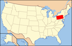 | |
|---|---|---|
| Lists by county |
| |
| Lists by city |
| |
| Other lists | ||
| ||
Municipalities and communities of Cambria County, Pennsylvania, United States | ||
|---|---|---|
| City | | |
| Boroughs |
| |
| Townships | ||
| CDPs |
| |
| Unincorporated communities | ||
| Footnotes | ‡This populated place also has portions in an adjacent county or counties | |
This article is issued from Wikipedia. The text is licensed under Creative Commons - Attribution - Sharealike. Additional terms may apply for the media files.