National Register of Historic Places listings in Blair County, Pennsylvania
This is a list of the National Register of Historic Places listings in Blair County, Pennsylvania.
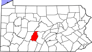
Location of Blair County in Pennsylvania
This is intended to be a complete list of the properties and districts on the National Register of Historic Places in Blair County, Pennsylvania, United States. The locations of National Register properties and districts for which the latitude and longitude coordinates are included below, may be seen in a map.[1]
There are 28 properties and districts listed on the National Register in the county. Two sites are further designated as National Historic Landmarks and another is designated a National Historic Site.
- This National Park Service list is complete through NPS recent listings posted June 19, 2020.[2]
Current listings
| [3] | Name on the Register | Image | Date listed[4] | Location | Municipality | Description |
|---|---|---|---|---|---|---|
| 1 | Allegheny Furnace |  Allegheny Furnace |
September 6, 1991 (#91001131) |
3400 Crescent Road 40°29′32″N 78°24′26″W |
Altoona | |
| 2 | Allegheny Portage Railroad National Historic Site | 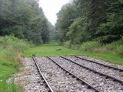 Allegheny Portage Railroad National Historic Site |
October 15, 1966 (#66000648) |
U.S. Route 22 40°27′15″N 78°32′25″W |
Allegheny Township | Extends into Conemaugh and Cresson Townships in Cambria County |
| 3 | Altoona Armory |  Altoona Armory |
May 9, 1991 (#91000507) |
327 Frankstown Road 40°28′53″N 78°23′50″W |
Logan Township | |
| 4 | Baker Mansion | 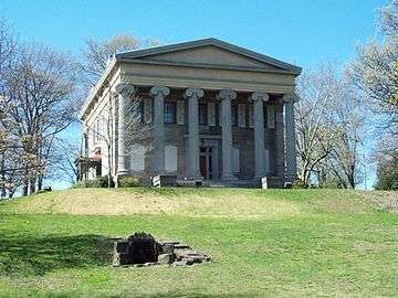 Baker Mansion |
June 5, 1975 (#75001619) |
3500 Baker Boulevard 40°29′26″N 78°24′30″W |
Altoona | |
| 5 | Birmingham Bridge | 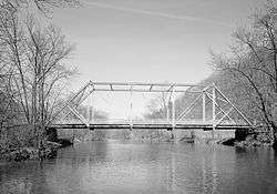 Birmingham Bridge |
March 20, 1990 (#90000400) |
Over the Juniata River, north of Birmingham off Pennsylvania Route 350 40°38′56″N 78°11′57″W |
Tyrone Township | Extends into Warriors Mark Township in Huntingdon County |
| 6 | Blair County Courthouse | 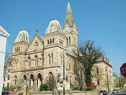 Blair County Courthouse |
June 17, 1976 (#76001606) |
423 Allegheny Street 40°25′49″N 78°23′33″W |
Hollidaysburg | |
| 7 | Broad Avenue Historic District |  Broad Avenue Historic District |
July 25, 2002 (#02000806) |
Roughly along Broad Avenue, from 23rd to 31st Streets 40°30′08″N 78°24′46″W |
Altoona | |
| 8 | Central Trust Company Buildings |  Central Trust Company Buildings |
November 1, 1984 (#84000271) |
1210–1218 11th Avenue 40°30′55″N 78°24′06″W |
Altoona | |
| 9 | Downtown Altoona Historic District |  Downtown Altoona Historic District |
July 24, 1992 (#92000946) |
Roughly bounded by 11th Avenue, 11th Street, 15th Avenue and 13th Street, also 700–1000 Lexington and 900–1000 Howard Avenues 40°30′59″N 78°24′08″W |
Altoona | Second set of boundaries represents a boundary increase of August 20, 2004 |
| 10 | Etna Furnace | 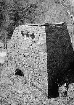 Etna Furnace |
April 11, 1973 (#73001593) |
North of Williamsburg: roughly the area south and east of the bend of the Frankstown Branch Juniata River at Mount Etna 40°31′34″N 78°11′11″W |
Catharine Township | Specific boundaries represent a boundary increase of September 6, 1991 |
| 11 | Fort Roberdeau |  Fort Roberdeau |
May 29, 1974 (#74001753) |
West of Culp off U.S. Route 220 40°34′57″N 78°16′26″W |
Tyrone Township | |
| 12 | Highland Hall |  Highland Hall |
September 13, 1978 (#78002351) |
517 Walnut Street 40°25′55″N 78°23′32″W |
Hollidaysburg | |
| 13 | Hollidaysburg Historic District |  Hollidaysburg Historic District |
December 26, 1985 (#85003158) |
Roughly bounded by Spruce, Bella, Blair, and Juniata Streets 40°25′48″N 78°23′29″W |
Hollidaysburg | |
| 14 | Horseshoe Curve |  Horseshoe Curve |
November 13, 1966 (#66000647) |
5 miles (8 km) west of Altoona on the Blair County Veterans Memorial Highway (SR 4008) 40°29′52″N 78°29′03″W |
Logan Township | |
| 15 | Jacob Isett House and Store |  Jacob Isett House and Store |
March 28, 1997 (#97000290) |
Legislative Route 1013, 0.3 miles (0.5 km) south of junction with Legislative Route 1015 40°36′16″N 78°12′25″W |
Tyrone Township | |
| 16 | D.S. Keith Junior High School |  D.S. Keith Junior High School |
December 11, 2011 (#11000922) |
1318 19th Avenue 40°31′11″N 78°24′32″W |
Altoona | Part of the Educational Resources of Pennsylvania MPS |
| 17 | Knickerbocker Historic District |  Knickerbocker Historic District |
February 20, 2002 (#02000064) |
4th, 5th and 6th Avenues, Burgoon Road, 40th and 41st Streets 40°29′11″N 78°24′50″W |
Altoona | |
| 18 | Leap-the-Dips | .jpg) Leap-the-Dips |
March 15, 1991 (#91000229) |
700 Park Avenue, Lakemont Park 40°28′15″N 78°23′48″W |
Logan Township | |
| 19 | Llyswen Historic District |  Llyswen Historic District |
July 25, 2002 (#02000807) |
Coleridge, Logan, Aldrich bounded by Mill Run and Ward 40°28′59″N 78°24′25″W |
Altoona | |
| 20 | Mishler Theatre |  Mishler Theatre |
April 11, 1973 (#73001592) |
1208 12th Avenue 40°30′59″N 78°24′07″W |
Altoona | |
| 21 | J.L. Noble School |  J.L. Noble School |
July 11, 1996 (#96000712) |
209 12th Avenue, Juniata 40°32′16″N 78°23′35″W |
Altoona | |
| 22 | Penn Alto Hotel | 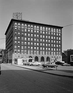 Penn Alto Hotel |
May 5, 1989 (#89000350) |
12th Street and 13th Avenue 40°31′01″N 78°24′09″W |
Altoona | |
| 23 | Roaring Spring Historic District | 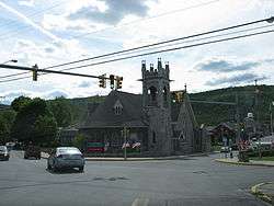 Roaring Spring Historic District |
March 3, 1995 (#95000133) |
Roughly bounded by Barley, Lower, Walnut, Roosevelt, California, Hickory, Fairview, Sugar and North Main Streets 40°20′05″N 78°23′56″W |
Roaring Spring | |
| 24 | Daniel Royer House | 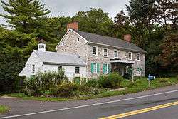 Daniel Royer House |
November 3, 1975 (#75001620) |
5 miles (8.0 km) southwest of Williamsburg on Pennsylvania Route 866 40°25′25″N 78°16′13″W |
Woodbury Township | |
| 25 | St. John's Evangelical Lutheran Church |  St. John's Evangelical Lutheran Church |
September 18, 1978 (#78002350) |
Sinking Valley on Old Water Street Road Northeast of Culp 40°35′39″N 78°15′01″W |
Tyrone Township | |
| 26 | Tyrone Armory |  Tyrone Armory |
December 22, 1989 (#89002083) |
956 South Logan Avenue 40°40′11″N 78°14′25″W |
Tyrone | |
| 27 | Tyrone Borough Historic District |  Tyrone Borough Historic District |
January 21, 1993 (#92001823) |
Roughly bounded by West 14th Street, Logan Avenue, Bald Eagle Avenue, the Little Juniata River, West 8th Street and Jefferson Avenue 40°40′19″N 78°14′26″W |
Tyrone | |
| 28 | Williamsburg Historic District | _621_W_2nd_St.jpg) Williamsburg Historic District |
May 12, 1995 (#95000518) |
Approximately 30 square blocks centered around Second and High Streets 40°27′39″N 78°12′14″W |
Williamsburg |
Former listings
| [3] | Name on the Register | Image | Date listed | Date removed | Location | City or town | Summary |
|---|---|---|---|---|---|---|---|
| 1 | Charles B. Dudley House | 1976 (#76001605) | January 3, 2001 | 802 Lexington Avenue |
Altoona | Demolished in late 1999.[5] |
See also
| Wikimedia Commons has media related to National Register of Historic Places in Blair County, Pennsylvania. |
References
- The latitude and longitude information provided in this table was derived originally from the National Register Information System, which has been found to be fairly accurate for about 99% of listings. Some locations in this table may have been corrected to current GPS standards.
- "National Register of Historic Places: Weekly List Actions". National Park Service, United States Department of the Interior. Retrieved on June 19, 2020.
- Numbers represent an ordering by significant words. Various colorings, defined here, differentiate National Historic Landmarks and historic districts from other NRHP buildings, structures, sites or objects.
- The eight-digit number below each date is the number assigned to each location in the National Register Information System database, which can be viewed by clicking the number.
| Topics |  | |
|---|---|---|
| Lists by county |
| |
| Lists by city |
| |
| Other lists | ||
| ||
Municipalities and communities of Blair County, Pennsylvania, United States | ||
|---|---|---|
| City | | |
| Boroughs | ||
| Townships | ||
| CDPs | ||
| Unincorporated communities |
| |
| Footnotes | ‡This populated place also has portions in an adjacent county or counties | |
This article is issued from Wikipedia. The text is licensed under Creative Commons - Attribution - Sharealike. Additional terms may apply for the media files.