National Register of Historic Places listings in McKean County, Pennsylvania
This is a list of the National Register of Historic Places listings in McKean County, Pennsylvania.
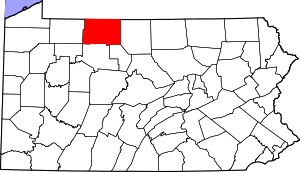
Location of McKean County in Pennsylvania
This is intended to be a complete list of the properties and districts on the National Register of Historic Places in McKean County, Pennsylvania. The locations of National Register properties and districts for which the latitude and longitude coordinates are included below, may be seen in a map.[1]
There are 10 properties and districts listed on the National Register in the county. Another property was once listed but has been removed.
- This National Park Service list is complete through NPS recent listings posted June 19, 2020.[2]
Current listings
| [3] | Name on the Register | Image | Date listed[4] | Location | City or town | Description |
|---|---|---|---|---|---|---|
| 1 | Anoatok | 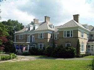 Anoatok |
January 7, 1986 (#86000039) |
230 Clay Street 41°39′50″N 78°47′57″W |
Kane | Georgian Colonial Revival style mansion constructed in 1896 for Dr. Elizabeth Dennistoun Wood Kane, wife of General Thomas L. Kane. |
| 2 | Rufus Barrett Stone House |  Rufus Barrett Stone House |
November 14, 1982 (#82001540) |
11 Boylston Street 41°57′24″N 78°39′01″W |
Bradford | Three story brick flatiron building constructed in 1903. |
| 3 | Bradford Armory | 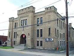 Bradford Armory |
May 9, 1991 (#91000508) |
28 Barbour Street 41°57′23″N 78°39′13″W |
Bradford | Brick armory dating to 1912; part of the Multiple Property Submission for the Pennsylvania National Guard Armories. |
| 4 | Bradford Downtown Historic District |  Bradford Downtown Historic District |
August 31, 2000 (#00001044) |
Roughly bounded by Central Alley, Barbour Street, Bushnell Street, Howard Place, Davis Street, and Boylston Street. 41°57′20″N 78°39′02″W |
Bradford | Features a number of 19th-century Italianate style commercial structures. |
| 5 | Bradford Old City Hall |  Bradford Old City Hall |
May 17, 1976 (#76002156) |
Kennedy and Boylston Streets 41°57′24″N 78°38′50″W |
Bradford | Eclectic Victorian city hall with four story clock tower. |
| 6 | Crook Farm |  Crook Farm |
March 26, 1976 (#76002157) |
Northeast of Bradford on Seaward Avenue 41°59′29″N 78°37′37″W |
Foster Township | Includes farmstead dating to 1856, and site of Olmstead Well. |
| 7 | Kane Armory |  Kane Armory |
May 9, 1991 (#91000512) |
Junction of Chestnut and Fraley Streets 41°39′28″N 78°48′43″W |
Kane | Brick armory dating to 1922-1929; part of the Multiple Property Submission for the Pennsylvania National Guard Armories. |
| 8 | Thomas L. Kane Memorial Chapel |  Thomas L. Kane Memorial Chapel |
March 29, 1978 (#78003089) |
30 Chestnut Street 41°39′28″N 78°48′32″W |
Kane | Gothic Revival chapel constructed in 1876 and dedicated to General Thomas L. Kane. |
| 9 | Lynn Hall |  Lynn Hall |
February 7, 2007 (#07000033) |
West side of U.S. Route 6, 1.5 miles (2.4 km) west of Port Allegany 41°49′36″N 78°18′26″W |
Liberty Township | Frank Lloyd Wright inspired restaurant and residence dating to 1935. |
| 10 | New Thomson House |  New Thomson House |
May 3, 1984 (#84003493) |
2 Greeves Street 41°39′33″N 78°48′39″W |
Kane | Six story hotel constructed in 1907; now mixed use building. |
Former listing
| [3] | Name on the Register | Image | Date listed | Date removed | Location | City or town | Summary |
|---|---|---|---|---|---|---|---|
| 1 | Kinzua Bridge | 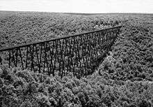 Kinzua Bridge |
August 29, 1977 (#77001511) | July 21, 2004 | 4.2 miles (6.8 km) northeast of Mount Jewett 41°45′45″N 78°35′18″W |
Hamlin and Keating Townships | Collapsed in a windstorm on July 21, 2003. |
See also
| Wikimedia Commons has media related to National Register of Historic Places in McKean County, Pennsylvania. |
References
- The latitude and longitude information provided in this table was derived originally from the National Register Information System, which has been found to be fairly accurate for about 99% of listings. Some locations in this table may have been corrected to current GPS standards.
- "National Register of Historic Places: Weekly List Actions". National Park Service, United States Department of the Interior. Retrieved on June 19, 2020.
- Numbers represent an ordering by significant words. Various colorings, defined here, differentiate National Historic Landmarks and historic districts from other NRHP buildings, structures, sites or objects.
- The eight-digit number below each date is the number assigned to each location in the National Register Information System database, which can be viewed by clicking the number.
| Topics | 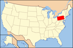 | |
|---|---|---|
| Lists by county |
| |
| Lists by city |
| |
| Other lists | ||
| ||
Municipalities and communities of McKean County, Pennsylvania, United States | ||
|---|---|---|
| City | | |
| Boroughs | ||
| Townships | ||
| CDPs | ||
| Unincorporated communities | ||
This article is issued from Wikipedia. The text is licensed under Creative Commons - Attribution - Sharealike. Additional terms may apply for the media files.