National Register of Historic Places listings in Bedford County, Pennsylvania
This is a list of the National Register of Historic Places listings in Bedford County, Pennsylvania.

Location of Bedford County in Pennsylvania
This is intended to be a complete list of the properties and districts on the National Register of Historic Places in Bedford County, Pennsylvania, United States. The locations of National Register properties and districts for which the latitude and longitude coordinates are included below, may be seen in a map.[1]
There are 32 properties and districts listed on the National Register in the county. Three sites are further designated as National Historic Landmarks. Another 2 properties were once listed but have been removed.
- This National Park Service list is complete through NPS recent listings posted June 19, 2020.[2]
Current listings
| [3] | Name on the Register | Image | Date listed[4] | Location | City or town | Description |
|---|---|---|---|---|---|---|
| 1 | Barclay House |  Barclay House |
September 18, 1978 (#78002342) |
230 Juliana Street 40°00′58″N 78°30′14″W |
Bedford | |
| 2 | Bedford County Alms House |  Bedford County Alms House |
November 3, 1988 (#88002378) |
Cumberland Road, .4 miles (0.64 km) south of Bedford 39°59′13″N 78°32′32″W |
Bedford Township | |
| 3 | Bedford Historic District | 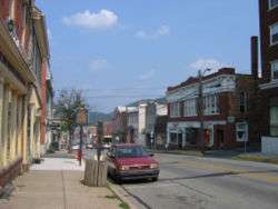 Bedford Historic District |
December 22, 1983 (#83004187) |
Roughly bounded by East, West, and Watson Streets, and the Raystown Branch of the Juniata River 40°01′03″N 78°30′06″W |
Bedford | |
| 4 | Bedford Springs Hotel Historic District | 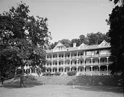 Bedford Springs Hotel Historic District |
December 20, 1984 (#84001413) |
U.S. Route 220, south of Bedford 39°59′10″N 78°31′08″W |
Bedford Township | |
| 5 | Bonnet's Tavern |  Bonnet's Tavern |
August 1, 1979 (#79002164) |
4 miles (6.4 km) west of Bedford at the junction of U.S. Route 30 and Pennsylvania Route 31 40°02′32″N 78°33′39″W |
Napier Township | |
| 6 | Bridge in Snake Spring Township |  Bridge in Snake Spring Township |
June 22, 1988 (#88000793) |
Township Road 30 over the Raystown Branch of the Juniata River, east of Bedford 40°00′49″N 78°28′18″W |
Snake Spring Township | |
| 7 | Chalybeate Springs Hotel |  Chalybeate Springs Hotel |
July 18, 1985 (#85001560) |
Chalybeate Road, north of Bedford 40°01′34″N 78°28′55″W |
Bedford Township | |
| 8 | Chestnut Ridge and Schellsburg Union Church and Cemetery |  Chestnut Ridge and Schellsburg Union Church and Cemetery |
January 12, 2005 (#04001482) |
U.S. Route 30 40°02′55″N 78°39′21″W |
Napier Township | |
| 9 | The Coffee Pot |  The Coffee Pot |
February 24, 2005 (#05000097) |
Business Route 30 40°01′23″N 78°31′02″W |
Bedford Township | |
| 10 | Defibaugh Tavern |  Defibaugh Tavern |
November 12, 1992 (#92001498) |
Northern side of U.S. Route 30, east of Bedford 40°01′34″N 78°27′10″W |
Snake Spring Township | |
| 11 | Diehls Covered Bridge | 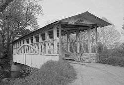 Diehls Covered Bridge |
April 10, 1980 (#80003420) |
South of Schellsburg on Legislative Route 09057, east of New Buena Vista 40°00′34″N 78°38′55″W |
Harrison Township | |
| 12 | Dutch Corner Historic Agricultural District |  Dutch Corner Historic Agricultural District |
August 17, 2015 (#15000533) |
Roughly bounded by Evitts Mountain, the Bedford Township line, the former Dunning Creek Railroad line, and the William Penn Highway 40°06′00″N 78°27′00″W |
Bedford Township | |
| 13 | East Broad Top Railroad |  East Broad Top Railroad |
October 15, 1966 (#66000666) |
1 mile (1.6 km) west of Orbisonia on U.S. Route 522 40°09′53″N 78°08′16″W |
Broad Top Township | Extends into multiple municipalities in Huntingdon County |
| 14 | Espy House | 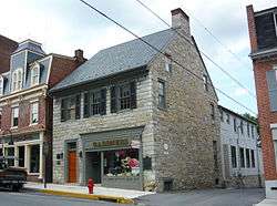 Espy House |
November 19, 1974 (#74001750) |
123 Pitt Street 40°01′10″N 78°30′11″W |
Bedford | |
| 15 | Everett Historic District |  Everett Historic District |
May 29, 2003 (#03000492) |
Roughly bounded by West 5th, Borough, and Hill Streets, River Lane, South Street, and Barndollar Avenue 40°00′41″N 78°22′24″W |
Everett | |
| 16 | Feltons Mill Covered Bridge | 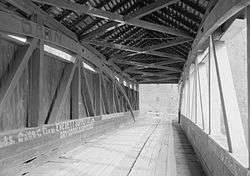 Feltons Mill Covered Bridge |
April 10, 1980 (#80003413) |
Legislative Route 05021, east of Bedford 39°58′22″N 78°17′20″W |
East Providence Township | |
| 17 | Fischtner Covered Bridge |  Fischtner Covered Bridge |
April 10, 1980 (#80003422) |
North of Stringtown off Legislative Route 05007 39°45′49″N 78°45′06″W |
Londonderry Township | |
| 18 | Halls Mill Covered Bridge | 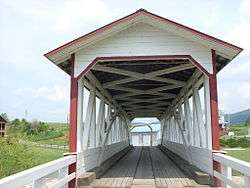 Halls Mill Covered Bridge |
April 10, 1980 (#80003418) |
North of Everett on Township 528 40°07′27″N 78°19′02″W |
Hopewell Township | |
| 19 | Heirline Covered Bridge | 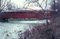 Heirline Covered Bridge |
April 10, 1980 (#80003419) |
West of Bedford on Legislative Route 05097, north of Manns Choice 40°01′00″N 78°35′37″W |
Harrison and Napier Townships | |
| 20 | Hewitt Covered Bridge |  Hewitt Covered Bridge |
April 10, 1980 (#80003417) |
Township 305 at Hewitt 39°45′16″N 78°30′40″W |
Southampton Township | |
| 21 | Jacksons Mill Covered Bridge | 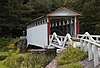 Jacksons Mill Covered Bridge |
April 10, 1980 (#80003414) |
Township 412, east of Bedford 39°58′16″N 78°16′19″W |
East Providence Township | |
| 22 | Juniata Woolen Mill and Newry Manor |  Juniata Woolen Mill and Newry Manor |
March 31, 1983 (#83002216) |
West of Everett on Lutzville Road 40°00′44″N 78°25′56″W |
Snake Spring Township | |
| 23 | Dr. Knisley Covered Bridge | 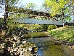 Dr. Knisley Covered Bridge |
April 10, 1980 (#80003411) |
Southeast of Alum Bank on Legislative Route 05098 40°09′36″N 78°36′08″W |
West St. Clair Township | |
| 24 | New Enterprise Public School |  New Enterprise Public School |
October 8, 1981 (#81000528) |
Off Pennsylvania Route 869 at New Enterprise 40°10′17″N 78°24′28″W |
South Woodbury Township | |
| 25 | New Paris Covered Bridge |  New Paris Covered Bridge |
April 10, 1980 (#80003423) |
1 mile (1.6 km) north of New Paris 40°06′58″N 78°38′23″W |
Napier Township | |
| 26 | Osterburg Covered Bridge | 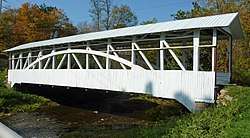 Osterburg Covered Bridge |
April 10, 1980 (#80003421) |
West of Osterburg on Township 757 40°10′37″N 78°32′30″W |
East St. Clair Township | |
| 27 | Russell House |  Russell House |
June 19, 1979 (#79002165) |
203 South Juliana Street 40°01′00″N 78°30′12″W |
Bedford | |
| 28 | Ryot Covered Bridge | 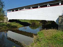 Ryot Covered Bridge |
April 10, 1980 (#80003416) |
South of Alum Bank on Township 559, northwest of Fishertown 40°08′32″N 78°37′30″W |
West St. Clair Township | |
| 29 | Schellsburg Historic District | 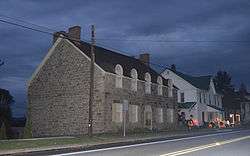 Schellsburg Historic District |
June 21, 2001 (#01000677) |
Approximately centered on Pitt Street, Market and Baltimore Streets 40°02′52″N 78°38′35″W |
Schellsburg | |
| 30 | Site 36BD90 | 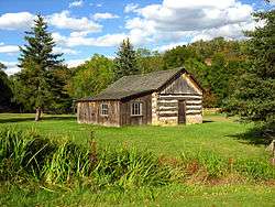 Site 36BD90 |
June 4, 1984 (#84003102) |
On the grounds of Bedford Village[5] 40°02′31″N 78°30′39″W |
Bedford Township | |
| 31 | Snooks Covered Bridge | 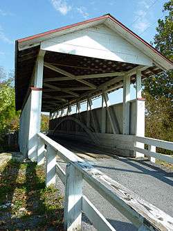 Snooks Covered Bridge |
April 10, 1980 (#80003412) |
East of Alum Bank on Township 578 40°10′09″N 78°34′48″W |
East St. Clair Township | |
| 32 | Woodvale Historic District |  Woodvale Historic District |
July 24, 1992 (#92000942) |
Roughly bounded by Ash, High, North, Fulton, and Broad Streets in Woodvale 40°10′01″N 78°08′17″W |
Broad Top Township | Extends into Wells Township in Fulton County and Wood Township in Huntingdon County |
Former listings
| [3] | Name on the Register | Image | Date listed | Date removed | Location | City or town | Summary |
|---|---|---|---|---|---|---|---|
| 1 | Grand View Point Hotel |  Grand View Point Hotel |
March 8, 1997 (#97000219) | January 14, 2002 | U.S. Route 30, 17 miles (27 km) west of Bedford, Juniata Township |
Juniata Township | Built 1932. Burned 2001 |
| 2 | McDaniels Covered Bridge |  McDaniels Covered Bridge |
April 10, 1980 (#80003415) | October 13, 1988 | Address Restricted |
East Providence Township and West Providence Township |
See also
| Wikimedia Commons has media related to National Register of Historic Places in Bedford County, Pennsylvania. |
References
- The latitude and longitude information provided in this table was derived originally from the National Register Information System, which has been found to be fairly accurate for about 99% of listings. Some locations in this table may have been corrected to current GPS standards.
- "National Register of Historic Places: Weekly List Actions". National Park Service, United States Department of the Interior. Retrieved on June 19, 2020.
- Numbers represent an ordering by significant words. Various colorings, defined here, differentiate National Historic Landmarks and historic districts from other NRHP buildings, structures, sites or objects.
- The eight-digit number below each date is the number assigned to each location in the National Register Information System database, which can be viewed by clicking the number.
- Location derived from its NRHP nomination form; the NRIS lists the site as "Address Restricted"
| Topics | 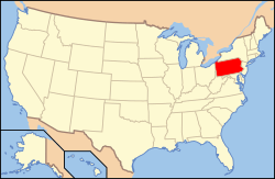 | |
|---|---|---|
| Lists by county |
| |
| Lists by city |
| |
| Other lists | ||
| ||
Municipalities and communities of Bedford County, Pennsylvania, United States | ||
|---|---|---|
| Boroughs | | |
| Townships | ||
| CDPs | ||
| Unincorporated communities | ||
| Footnotes | ‡This populated place also has portions in an adjacent county or counties | |
This article is issued from Wikipedia. The text is licensed under Creative Commons - Attribution - Sharealike. Additional terms may apply for the media files.