National Register of Historic Places listings in Northumberland County, Pennsylvania
This is a list of the National Register of Historic Places listings in Northumberland County, Pennsylvania.

Location of Northumberland County in Pennsylvania
This is intended to be a complete list of the properties and districts on National Register of Historic Places in Northumberland County, Pennsylvania. The locations of National Register properties and districts for which the latitude and longitude coordinates are included below, may be seen in a map.[1]
There are 29 properties and districts listed on the National Register in the county. One site is further designated as a National Historic Landmark. Another property was once listed but has been removed.
- This National Park Service list is complete through NPS recent listings posted June 26, 2020.[2]
Current listings
| [3] | Name on the Register | Image | Date listed[4] | Location | City or town | Description |
|---|---|---|---|---|---|---|
| 1 | Allenwood River Bridge |  Allenwood River Bridge |
June 22, 1988 (#88000865) |
Legislative Route 460 over the West Branch of the Susquehanna River 41°06′28″N 76°53′25″W |
Delaware Township | Bridge was replaced with a new structure in 1990. It extended into Gregg Township in Union County |
| 2 | Beck House | _1.JPG) Beck House |
January 11, 1976 (#76001659) |
62 North Front Street 40°51′50″N 76°47′46″W |
Sunbury | |
| 3 | Gottlieb Brown Covered Bridge | 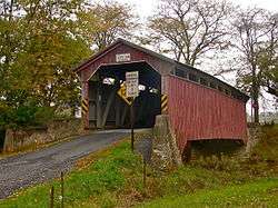 Gottlieb Brown Covered Bridge |
August 8, 1979 (#79002311) |
East of Potts Grove on Township 594 41°00′06″N 76°46′26″W |
East Chillisquaque Township | Extends into Liberty Township in Montour County |
| 4 | Col. James Cameron House |  Col. James Cameron House |
May 5, 1989 (#89000360) |
Pennsylvania Route 405/River Road, southeast of Milton 41°00′08″N 76°51′43″W |
West Chillisquaque Township | |
| 5 | Dauphin County Bridge No. 27 |  Dauphin County Bridge No. 27 |
August 2, 1993 (#93000720) |
Deibler's Dam Road (Mahantango Creek Road) across Mahantango Creek 40°38′05″N 76°51′23″W |
Lower Mahanoy Township | Extends into Mifflin Township in Dauphin County. Photo shows replacement bridge |
| 6 | Himmel's Church Covered Bridge | 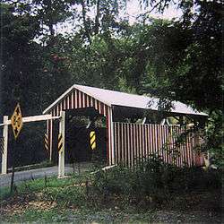 Himmel's Church Covered Bridge |
August 8, 1979 (#79002312) |
Northeast of Rebuck on Township 442 40°43′23″N 76°43′12″W |
Washington Township | |
| 7 | Hopper-Snyder Homestead | 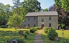 Hopper-Snyder Homestead |
July 3, 1979 (#79002315) |
Northeast of Watsontown off Pennsylvania Route 49061 41°05′39″N 76°51′21″W |
Delaware Township | |
| 8 | Hower-Slote House |  Hower-Slote House |
August 22, 1979 (#79002314) |
West of Turbotville 41°06′06″N 76°47′45″W |
Lewis Township | |
| 9 | Keefer Station Covered Bridge |  Keefer Station Covered Bridge |
August 8, 1979 (#79002313) |
East of Sunbury on Township 698 40°52′14″N 76°43′25″W |
Upper Augusta Township | |
| 10 | William Kirk House |  William Kirk House |
December 2, 1980 (#80003590) |
West of Turbotville 41°05′56″N 76°48′43″W |
Delaware Township | |
| 11 | Lawrence L. Knoebel Covered Bridge | 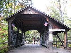 Lawrence L. Knoebel Covered Bridge |
August 8, 1979 (#79002309) |
Knoebel's Grove 40°52′38″N 76°30′21″W |
Ralpho Township | Extends into Cleveland Township in Columbia County |
| 12 | Kreigbaum Covered Bridge |  Kreigbaum Covered Bridge |
August 8, 1979 (#79002316) |
East of Elysburg on Township 459 40°50′51″N 76°30′29″W |
Ralpho Township | Extends into Cleveland Township in Columbia County |
| 13 | Milton Armory |  Milton Armory |
July 12, 1991 (#91000905) |
133 Ridge Avenue 41°01′01″N 76°50′58″W |
Milton | |
| 14 | Milton Freight Station |  Milton Freight Station |
April 13, 1977 (#77001180) |
90 Broadway 41°01′10″N 76°51′08″W |
Milton | |
| 15 | Milton Historic District |  Milton Historic District |
July 24, 1986 (#86001933) |
Roughly bounded by 8th and Upper Market Streets, Spruce Avenue, and Stanton, High and Apple Streets, and the Susquehanna River 41°01′20″N 76°50′59″W |
Milton | |
| 16 | Northumberland County Courthouse | 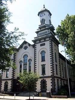 Northumberland County Courthouse |
December 30, 1974 (#74001800) |
207 Market Street 40°51′42″N 76°47′43″W |
Sunbury | |
| 17 | Northumberland Historic District |  Northumberland Historic District |
November 18, 1988 (#88002313) |
Roughly bounded by Fourth and A Streets, the North Shore Railroad, and Wheatley Avenue 40°53′26″N 76°47′39″W |
Northumberland | |
| 18 | Pennsylvania Canal and Limestone Run Aqueduct | 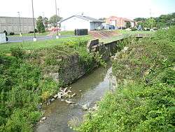 Pennsylvania Canal and Limestone Run Aqueduct |
December 19, 1978 (#78002438) |
Bounded by Broadway, Filbert Street, Limestone Run, and Bound Avenue 41°01′07″N 76°51′13″W |
Milton | |
| 19 | Dr. Joseph Priestley House |  Dr. Joseph Priestley House |
September 11, 1981 (#81000554) |
100 King Street 40°53′20″N 76°47′37″W |
Northumberland | |
| 20 | Joseph Priestley House | 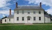 Joseph Priestley House |
October 15, 1966 (#66000673) |
Priestley Avenue 40°53′24″N 76°47′25″W |
Northumberland | |
| 21 | Richards Covered Bridge | 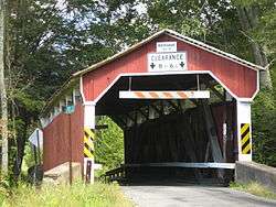 Richards Covered Bridge |
August 8, 1979 (#79002308) |
East of Elysburg on Township 804 40°52′03″N 76°30′29″W |
Ralpho Township | Extends into Cleveland Township in Columbia County |
| 22 | Rishel Covered Bridge | 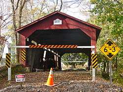 Rishel Covered Bridge |
August 8, 1979 (#79002310) |
East of Montandon on Township 573 40°57′37″N 76°48′58″W |
East and West Chillisquaque Townships | |
| 23 | Caspar Snyder House | 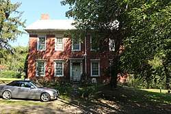 Caspar Snyder House |
November 24, 1978 (#09000101) |
Pennsylvania Route 47, south of Sunbury 40°46′53″N 76°50′31″W |
Lower Augusta Township | |
| 24 | Sodom Schoolhouse |  Sodom Schoolhouse |
February 12, 1974 (#74001799) |
East of Montandon on Pennsylvania Route 45 40°57′57″N 76°49′38″W |
West Chillisquaque Township | |
| 25 | Sunbury Armory | 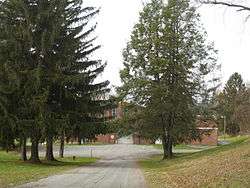 Sunbury Armory |
December 22, 1989 (#89002082) |
Catawissa Avenue, northeast of Sunbury 40°52′22″N 76°46′40″W |
Upper Augusta Township | |
| 26 | Sunbury Historic District | 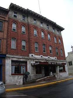 Sunbury Historic District |
November 3, 1983 (#83004240) |
Roughly bounded by Arch, Chestnut, Front, and 5th Streets 40°51′42″N 76°47′37″W |
Sunbury | |
| 27 | Warrior Run Presbyterian Church |  Warrior Run Presbyterian Church |
April 2, 1973 (#73001659) |
North of McEwensville on Pennsylvania Route 147 41°05′55″N 76°48′25″W |
Delaware Township | |
| 28 | Watsontown River Bridge | 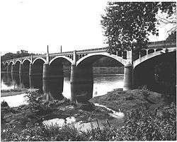 Watsontown River Bridge |
June 22, 1988 (#88000801) |
Legislative Route 240 spur over the West Branch of the Susquehanna River 41°04′51″N 76°51′55″W |
Watsontown | Extends into White Deer Township in Union County |
| 29 | Zion Stone Church |  Zion Stone Church |
November 1, 1984 (#84000267) |
Tulpehocken Road in Augustaville 40°48′12″N 76°44′29″W |
Rockefeller Township |
Former listing
| [3] | Name on the Register | Image | Date listed | Date removed | Location | City or town | Summary |
|---|---|---|---|---|---|---|---|
| 1 | Victoria Theatre | November 21, 1985 (#85002907) | May 18, 2004 | 46 West Independence Street |
Shamokin |
See also
| Wikimedia Commons has media related to National Register of Historic Places in Northumberland County, Pennsylvania. |
References
- The latitude and longitude information provided in this table was derived originally from the National Register Information System, which has been found to be fairly accurate for about 99% of listings. Some locations in this table may have been corrected to current GPS standards.
- "National Register of Historic Places: Weekly List Actions". National Park Service, United States Department of the Interior. Retrieved on June 26, 2020.
- Numbers represent an ordering by significant words. Various colorings, defined here, differentiate National Historic Landmarks and historic districts from other NRHP buildings, structures, sites or objects.
- The eight-digit number below each date is the number assigned to each location in the National Register Information System database, which can be viewed by clicking the number.
| Topics | 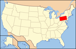 | |
|---|---|---|
| Lists by county |
| |
| Lists by city |
| |
| Other lists | ||
| ||
Municipalities and communities of Northumberland County, Pennsylvania, United States | ||
|---|---|---|
| Cities | | |
| Boroughs | ||
| Townships | ||
| CDPs | ||
| Unincorporated communities | ||
This article is issued from Wikipedia. The text is licensed under Creative Commons - Attribution - Sharealike. Additional terms may apply for the media files.