National Register of Historic Places listings in Juniata County, Pennsylvania
This is a list of the National Register of Historic Places listings in Juniata County, Pennsylvania.
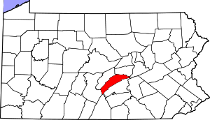
Location of Juniata County in Pennsylvania
This is intended to be a complete list of the properties and districts on the National Register of Historic Places in Juniata County, Pennsylvania, United States. The locations of National Register properties and districts for which the latitude and longitude coordinates are included below, may be seen in a map.[1]
There are 7 properties and districts listed on the National Register in the county.
- This National Park Service list is complete through NPS recent listings posted June 19, 2020.[2]
Current listings
| [3] | Name on the Register | Image | Date listed[4] | Location | City or town | Description |
|---|---|---|---|---|---|---|
| 1 | Academia Pomeroy Covered Bridge | .jpg) Academia Pomeroy Covered Bridge |
August 10, 1979 (#79002249) |
Northwest of Spruce Hill 40°29′37″N 77°28′21″W |
Beale and Spruce Hill Townships | |
| 2 | Book Site (36 Jul) |  Book Site (36 Jul) |
January 3, 1986 (#86000067) |
Off Legislative Route 3019[5] 40°28′44″N 77°30′02″W |
Beale Township | |
| 3 | Dimmsville Covered Bridge |  Dimmsville Covered Bridge |
August 10, 1979 (#79002245) |
West of Dimmsville 40°36′23″N 77°08′20″W |
Greenwood Township | |
| 4 | East Oriental Covered Bridge |  East Oriental Covered Bridge |
August 10, 1979 (#79002246) |
Northeast of Oriental 40°38′20″N 77°00′05″W |
Susquehanna Township | Extends into Perry Township in Snyder County |
| 5 | Lehman's, Port Royal Covered Bridge |  Lehman's, Port Royal Covered Bridge |
August 10, 1979 (#79002248) |
Southwest of Port Royal 40°31′45″N 77°23′45″W |
Turbett Township | |
| 6 | North Oriental Covered Bridge | 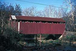 North Oriental Covered Bridge |
August 10, 1979 (#79002247) |
Northeast of Oriental 40°39′42″N 77°00′41″W |
Susquehanna Township | Extends into Perry Township in Snyder County |
| 7 | Tuscarora Academy |  Tuscarora Academy |
June 30, 1972 (#72001125) |
8 miles (13 km) south of Mifflintown at junction of Pennsylvania Routes 34005 and 34028 40°29′51″N 77°29′18″W |
Beale Township |
See also
| Wikimedia Commons has media related to National Register of Historic Places in Juniata County, Pennsylvania. |
References
- The latitude and longitude information provided in this table was derived originally from the National Register Information System, which has been found to be fairly accurate for about 99% of listings. Some locations in this table may have been corrected to current GPS standards.
- "National Register of Historic Places: Weekly List Actions". National Park Service, United States Department of the Interior. Retrieved on June 19, 2020.
- Numbers represent an ordering by significant words. Various colorings, defined here, differentiate National Historic Landmarks and historic districts from other NRHP buildings, structures, sites or objects.
- The eight-digit number below each date is the number assigned to each location in the National Register Information System database, which can be viewed by clicking the number.
- Location derived from its NRHP nomination form; the NRIS lists the site as "Address Restricted"
| Topics |  | |
|---|---|---|
| Lists by county |
| |
| Lists by city |
| |
| Other lists | ||
| ||
Municipalities and communities of Juniata County, Pennsylvania, United States | ||
|---|---|---|
| Boroughs | | |
| Townships | ||
| CDPs | ||
| Unincorporated communities | ||
| Footnotes | ‡This populated place also has portions in an adjacent county or counties. | |
This article is issued from Wikipedia. The text is licensed under Creative Commons - Attribution - Sharealike. Additional terms may apply for the media files.