National Register of Historic Places listings in Lawrence County, Pennsylvania
This is a list of the National Register of Historic Places listings in Lawrence County, Pennsylvania.
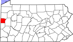
Location of Lawrence County in Pennsylvania
This is intended to be a complete list of the properties and districts on National Register of Historic Places in Lawrence County, Pennsylvania, United States. The locations of National Register properties and districts for which the latitude and longitude coordinates are included below, may be seen in a map.[1]
There are 9 properties and districts listed on the National Register in the county.
- This National Park Service list is complete through NPS recent listings posted June 26, 2020.[2]
Current listings
| [3] | Name on the Register | Image | Date listed[4] | Location | City or town | Description |
|---|---|---|---|---|---|---|
| 1 | Banks Covered Bridge |  Banks Covered Bridge |
June 27, 1980 (#80003543) |
Southeast of New Wilmington on Township 476 41°05′26″N 80°17′10″W |
Wilmington Township | |
| 2 | Lawrence County Courthouse | 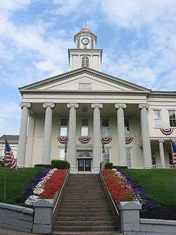 Lawrence County Courthouse |
December 15, 1978 (#78002419) |
Court Street 40°59′54″N 80°20′22″W |
New Castle | |
| 3 | McClelland Homestead | 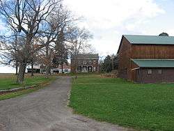 McClelland Homestead |
May 17, 1989 (#89000359) |
McClelland Road northeast of Bessemer 40°59′37″N 80°27′03″W |
North Beaver Township | |
| 4 | McConnell's Mill Covered Bridge |  McConnell's Mill Covered Bridge |
June 27, 1980 (#80003544) |
North of Portersville and south of Rose Point on Township 415 40°57′10″N 80°10′14″W |
Slippery Rock Township | |
| 5 | New Castle Armory |  New Castle Armory |
May 9, 1991 (#91000516) |
820 Frank Avenue 40°58′45″N 80°19′30″W |
Shenango Township | |
| 6 | North Hill Historic District |  North Hill Historic District |
February 18, 2000 (#00000056) |
Roughly Delaware, Neshannock, Hill Crest and Fairmont Avenues, and Crescent, Falls, Beaver, Jefferson and Mercer Streets 41°00′43″N 80°20′28″W |
New Castle | |
| 7 | Old Homestead | 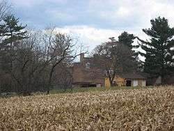 Old Homestead |
August 22, 1980 (#80003542) |
Northwest of Enon Valley off Pennsylvania Route 351 40°52′28″N 80°28′17″W |
Little Beaver Township | |
| 8 | S.R. Thompson House | 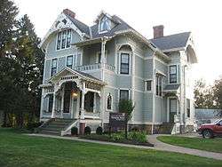 S.R. Thompson House |
March 7, 1985 (#85000467) |
400 Market Street 41°07′07″N 80°20′01″W |
New Wilmington | |
| 9 | Scottish Rite Cathedral | 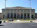 Scottish Rite Cathedral |
December 30, 2008 (#08001266) |
110 East Lincoln Avenue 41°00′19″N 80°20′41″W |
New Castle |
See also
References
| Wikimedia Commons has media related to National Register of Historic Places in Lawrence County, Pennsylvania. |
- The latitude and longitude information provided in this table was derived originally from the National Register Information System, which has been found to be fairly accurate for about 99% of listings. Some locations in this table may have been corrected to current GPS standards.
- "National Register of Historic Places: Weekly List Actions". National Park Service, United States Department of the Interior. Retrieved on June 26, 2020.
- Numbers represent an ordering by significant words. Various colorings, defined here, differentiate National Historic Landmarks and historic districts from other NRHP buildings, structures, sites or objects.
- The eight-digit number below each date is the number assigned to each location in the National Register Information System database, which can be viewed by clicking the number.
| Topics | 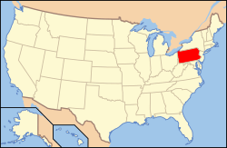 | |
|---|---|---|
| Lists by county |
| |
| Lists by city |
| |
| Other lists | ||
| ||
| Historic district | ||
|---|---|---|
| Other properties | ||
| Owner objected to listing |
| |
Municipalities and communities of Lawrence County, Pennsylvania, United States | ||
|---|---|---|
| City | | |
| Boroughs | ||
| Townships | ||
| CDPs | ||
| Unincorporated communities | ||
| Footnotes | ‡This populated place also has portions in an adjacent county or counties | |
This article is issued from Wikipedia. The text is licensed under Creative Commons - Attribution - Sharealike. Additional terms may apply for the media files.