Near Northeast Philadelphia
Near Northeast Philadelphia, is a section of the city of Philadelphia. When combined with the Far Northeast, to be "Northeast Philadelphia", the 2000 Census shows that the combined area has a sizable percentage of the city's 1.547 million people[1] — a population of between 300,000 and 450,000, depending on how the area is defined. Beginning in the 1980s, many of the Northeast's middle class children graduated from college and settled in suburbs, especially nearby Bucks County. Whites were once predominant in northeastern Philadelphia. However, with the emigration of older populations and white flight a new influx of Hispanics have settled in the Northeast, while African Americans and Asian immigrants have purchased homes in northeast Philadelphia. The Northeast is now both racially and ethnically diverse and has a large immigrant population.
|
|
|
|
|
|
|
Near Northeast Philadelphia | |
|---|---|
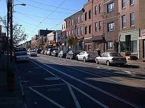 Richmond Street, one of the area’s main thoroughfares in Port Richmond (2005) in Near Northeast Philadelphia. | |
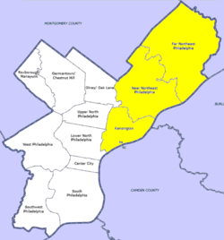 Map of Philadelphia County with Northeast highlighted, which contains the Near Northeast neighborhood. Click for larger image. | |
| Country | |
| State | |
| County | |
| City | |
| Area | |
| • Total | 37.94 sq mi (98.3 km2) |
| Population (2010) | |
| • Total | 396,691 |
| • Density | 10,455/sq mi (4,037/km2) |
| ZIP code | 19111, 19124, 19135, 19149 |
Demographics
The demographics of Near Northeast Philadelphia shows that the area has a population 396,691, with 190,951 males, 205,741 females and a median age of 33.[2]
References
- "Philadelphia County Quick Facts". US Census Bureau Official Website. US Census Bureau. August 16, 2009. Archived from the original on July 16, 2011. Retrieved August 16, 2009.
- "Near Northeast Philadelphia, Philadelphia, PA".
- "Factfinder at census.gov". Archived from the original on 2011-12-01. Retrieved 2013-10-14.
- "2010 Census". Medgar Evers College. Archived from the original on 2010-06-11. Retrieved 2010-04-13.