National Register of Historic Places listings in Greene County, Pennsylvania
This is a list of the National Register of Historic Places listings in Greene County, Pennsylvania.
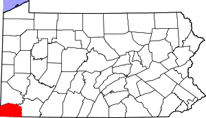
Location of Greene County in Pennsylvania
This is intended to be a complete list of the properties and districts on National Register of Historic Places in Greene County, Pennsylvania, United States. The locations of National Register properties and districts for which the latitude and longitude coordinates are included below, may be seen in a map.[1]
There are 44 properties and districts listed on the National Register in the county, including one National Historic Landmark. One property was once listed, but has since been removed.
- This National Park Service list is complete through NPS recent listings posted June 26, 2020.[2]
Current listings
| [3] | Name on the Register | Image | Date listed[4] | Location | Municipality | Description |
|---|---|---|---|---|---|---|
| 1 | Alexander V. Boughner House |  Alexander V. Boughner House |
March 9, 1995 (#95000114) |
Junction of 2nd and Minor Streets 39°47′31″N 79°54′50″W |
Greensboro | |
| 2 | Bridge in Franklin Township |  Bridge in Franklin Township |
June 22, 1988 (#88000766) |
Pennsylvania Route 188 over Ten Mile Creek at Morrisville 39°54′08″N 80°09′20″W |
Franklin Township | |
| 3 | Carmichaels Covered Bridge |  Carmichaels Covered Bridge |
June 22, 1979 (#79003815) |
Old Town Road and Muddy Creek 39°53′55″N 79°58′38″W |
Carmichaels | |
| 4 | Colver-Rogers Farmstead |  Colver-Rogers Farmstead |
November 21, 2003 (#03001191) |
East of State Route 1011 at Township 159, north of Jefferson 39°56′29″N 80°03′41″W |
Morgan Township | |
| 5 | John Corbley Farm | 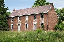 John Corbley Farm |
May 3, 1984 (#84003380) |
North of Garards Fort 39°49′32″N 80°01′33″W |
Greene Township | |
| 6 | John Minor Crawford House | 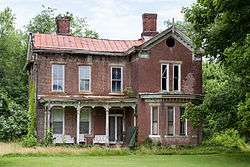 John Minor Crawford House |
July 27, 1995 (#95000122) |
State Route 2014 in Glassworks 39°48′04″N 79°54′50″W |
Monongahela Township | |
| 7 | William Crawford House | 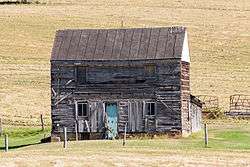 William Crawford House |
November 12, 1992 (#92001496) |
Off the junction of Brown's Ferry Road and Stevenson's Lane, east of Carmichaels 39°53′39″N 79°56′57″W |
Cumberland Township | |
| 8 | William Cree House | 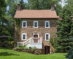 William Cree House |
July 15, 2002 (#01000678) |
Western side of State Route 1011, 0.1 miles (0.16 km) north of Pennsylvania Route 21 39°53′29″N 80°02′44″W |
Jefferson Township | |
| 9 | Horn Davis Overholtzer Bridge | 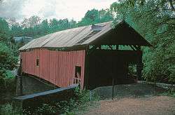 Horn Davis Overholtzer Bridge |
June 22, 1979 (#79002354) |
Southeast of Fairfield 40°00′29″N 80°03′45″W |
Morgan Township | The bridge collapsed in 1994. It extended into Washington County |
| 10 | Fisher Site (36GR21) | 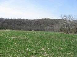 Fisher Site (36GR21) |
November 15, 1982 (#82001536) |
Off Camp Resort Road along Enlow Fork Wheeling Creek, south of West Finley[5] 39°57′36″N 80°28′00″W |
Richhill Township | |
| 11 | Richard T. Foley Site (36GR52) | 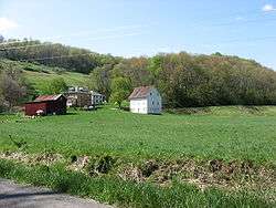 Richard T. Foley Site (36GR52) |
May 10, 1984 (#84003385) |
Along Job Creek, southwest of Holbrook[6] 39°49′51″N 80°22′54″W |
Jackson Township | |
| 12 | Glassworks-Core House | 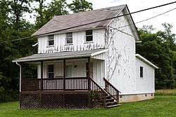 Glassworks-Core House |
July 27, 1995 (#95000121) |
State Route 2014 in Glassworks 39°48′00″N 79°54′48″W |
Monongahela Township | |
| 13 | Glassworks-Gabler House | 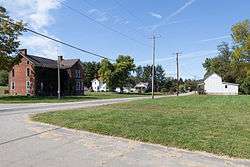 Glassworks-Gabler House |
July 27, 1995 (#95000120) |
State Route 2014 in Glassworks 39°48′00″N 79°54′48″W |
Monongahela Township | Google Earth images show this house was present in 1995, but missing in 2005 and subsequent images; it has been demolished. |
| 14 | George West Gordon Farm |  George West Gordon Farm |
August 24, 2000 (#00000965) |
333 Mary Hoge Road, 0.3 miles (0.48 km) southwest of Gordon Hill 39°51′21″N 80°09′14″W |
Whiteley Township | |
| 15 | Greene Academy |  Greene Academy |
December 12, 1976 (#76001643) |
314 North Market Street 39°53′58″N 79°58′38″W |
Carmichaels | |
| 16 | Greene Hills Farm | 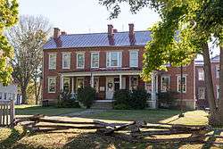 Greene Hills Farm |
April 23, 1973 (#73001634) |
3.5 miles (5.6 km) east of Waynesburg on Pennsylvania Route 21 39°53′20″N 80°07′29″W |
Franklin Township | |
| 17 | Greensboro Historic District | 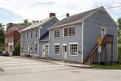 Greensboro Historic District |
November 17, 1995 (#95000118) |
Roughly bounded by County, Second, Walnut, Front and Clear Streets and the Monongahela River 39°47′29″N 79°54′45″W |
Greensboro | |
| 18 | Greensboro Public School | 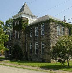 Greensboro Public School |
March 9, 1995 (#95000113) |
Junction of Second and Clear Streets 39°47′36″N 79°54′45″W |
Greensboro | |
| 19 | Grimes Covered Bridge |  Grimes Covered Bridge |
June 22, 1979 (#79003820) |
Off Pennsylvania Route 221 at the crossing of Ruff Creek, north of Waynesburg 39°57′16″N 80°09′35″W |
Washington Township | The bridge was destroyed by a fire in 1992. |
| 20 | Hamilton-Ely Farmstead |  Hamilton-Ely Farmstead |
March 2, 2006 (#06000098) |
1055 Sugar Run Road 39°50′17″N 80°10′43″W |
Whiteley Township | |
| 21 | Hanna Hall |  Hanna Hall |
April 18, 1979 (#79002235) |
College Street 39°53′58″N 80°11′13″W |
Waynesburg | |
| 22 | Charles Grant Heasley House |  Charles Grant Heasley House |
February 21, 1991 (#91000091) |
75 Sherman Avenue in the Bonar Addition, east of Waynesburg 39°53′50″N 80°10′30″W |
Franklin Township | |
| 23 | Hughes House | 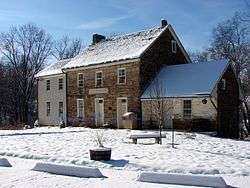 Hughes House |
December 27, 1972 (#72001124) |
Hatfield Street, north of Jefferson 39°55′58″N 80°03′36″W |
Jefferson Township | |
| 24 | James Jones House |  James Jones House |
March 9, 1995 (#95000112) |
Junction of Front and Stone Streets 39°47′37″N 79°54′41″W |
Greensboro | |
| 25 | Thomas Kent, Jr., Farm |  Thomas Kent, Jr., Farm |
August 16, 2000 (#00000882) |
208 Laurel Run Road, south of Waynesburg 39°52′24″N 80°10′00″W |
Franklin Township | |
| 26 | King Covered Bridge |  King Covered Bridge |
June 22, 1979 (#79003816) |
South of Kuhntown at the crossing of Hoover Run 39°45′25″N 80°16′21″W |
Wayne Township | |
| 27 | Lippincott Covered Bridge | 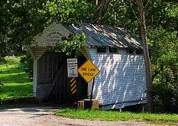 Lippincott Covered Bridge |
June 22, 1979 (#79003823) |
Off Pennsylvania Route 221 at the crossing of Ruff Creek, northeast of Waynesburg 39°56′36″N 80°07′35″W |
Morgan Township | |
| 28 | Marion Bridge |  Marion Bridge |
June 22, 1988 (#88000841) |
Pennsylvania Route 88 over the Monongahela River 39°44′22″N 79°54′19″W |
Dunkard Township | Demolished November 16, 2009.[7] Extended into Fayette County. |
| 29 | Mason and Dixon Survey Terminal Point | 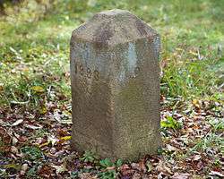 Mason and Dixon Survey Terminal Point |
June 25, 1973 (#73001922) |
2.25 miles (3.62 km) northeast of Pentress on Monongalia County Route 39 39°43′16″N 80°07′07″W |
Perry Township | Extends into Monongalia County, West Virginia |
| 30 | McClelland-Grimes Farm |  McClelland-Grimes Farm |
June 28, 2010 (#09000386) |
844 Craynes Run Rd. 39°57′44″N 80°09′00″W |
Morgan and Washington Townships | |
| 31 | Miller Hall |  Miller Hall |
April 14, 1978 (#78002405) |
51 West College Street 39°53′58″N 80°11′17″W |
Waynesburg | |
| 32 | James Parreco House | 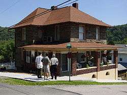 James Parreco House |
March 9, 1995 (#95000115) |
Junction of Third and Clear Streets 39°47′38″N 79°54′48″W |
Greensboro | |
| 33 | Peters-Graham House | 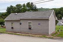 Peters-Graham House |
March 9, 1995 (#95000116) |
Junction of Walnut and Second Streets 39°47′34″N 79°54′47″W |
Greensboro | |
| 34 | Reppert-Gabler House | 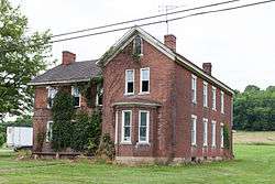 Reppert-Gabler House |
July 27, 1995 (#95000117) |
State Route 2014 in Glassworks 39°47′58″N 79°54′49″W |
Monongahela Township | |
| 35 | John Rex Farm |  John Rex Farm |
May 8, 1998 (#98000443) |
0.5 miles (0.80 km) east of Jefferson on Pennsylvania Route 188 39°56′16″N 80°02′54″W |
Jefferson Township | |
| 36 | Rice's Landing Historic District | 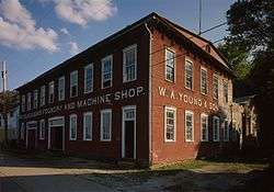 Rice's Landing Historic District |
December 24, 1992 (#92001723) |
Roughly bounded by the Monongahela River, Water, Second, Bayard, Carmichael, High, Main and Ferry including Pumpkin Run Peak 39°56′57″N 80°00′00″W |
Rices Landing | |
| 37 | Scott Covered Bridge |  Scott Covered Bridge |
June 22, 1979 (#79003819) |
Covered Bridge Road off Pennsylvania Route 21 at the crossing of Ten Mile Creek, west of Rogersville 39°53′15″N 80°19′33″W |
Center Township | |
| 38 | Shriver Covered Bridge | 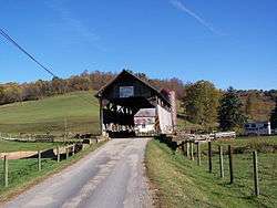 Shriver Covered Bridge |
June 22, 1979 (#79003821) |
South of Rogersville at the crossing of Harqus Creek 39°51′09″N 80°16′46″W |
Center Township | |
| 39 | Sugar Grove Petroglyph Site (36GR5) |  Sugar Grove Petroglyph Site (36GR5) |
March 20, 1986 (#86000476) |
Off Pennsylvania Route 88, 0.7 miles (1.1 km) northwest of its bridge over Whiteley Creek[8] 39°49′36″N 79°57′40″W |
Monongahela Township | |
| 40 | Ernest Thralls House |  Ernest Thralls House |
May 12, 1999 (#99000513) |
Pennsylvania Route 218 at Township Routes 353 and 522, south of Spraggs 39°45′07″N 80°13′04″W |
Wayne Township | Demolished ca. 2006 due to mine subsidence.[9] |
| 41 | Waynesburg Historic District | 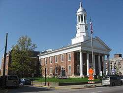 Waynesburg Historic District |
March 1, 1984 (#84003392) |
Roughly bounded by 2nd Alley, Cherry Avenue, East and Bowlby Streets 39°53′51″N 80°11′18″W |
Waynesburg | |
| 42 | White Covered Bridge |  White Covered Bridge |
June 22, 1979 (#79003822) |
Roberts Run Road, west of Garards Fort at the crossing of Whiteley Creek 39°48′24″N 80°03′39″W |
Greene Township | |
| 43 | Nettie Woods Covered Bridge | 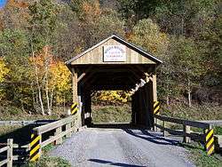 Nettie Woods Covered Bridge |
June 22, 1979 (#79003818) |
North of Oak Forest at the crossing of Pursley Creek 39°51′47″N 80°14′04″W |
Center Township | |
| 44 | W. A. Young and Sons Foundry and Machine Shop | W. A. Young and Sons Foundry and Machine Shop |
December 23, 2016 (#100000839) |
116 Water St. 39°56′59″N 79°59′57″W |
Rices Landing |
Former listings
| [3] | Name on the Register | Image | Date listed | Date removed | Location | City or town | Summary |
|---|---|---|---|---|---|---|---|
| 1 | Neils Red Covered Bridge | 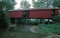 Neils Red Covered Bridge |
June 22, 1979 (#79003817) | March 22, 2018 | East of Garards Fort at the crossing of Whiteley Creek 39°48′43″N 80°00′50″W |
Greene Township | Destroyed by arson in 1990. |
See also
| Wikimedia Commons has media related to National Register of Historic Places in Greene County, Pennsylvania. |
References
- The latitude and longitude information provided in this table was derived originally from the National Register Information System, which has been found to be fairly accurate for about 99% of listings. Some locations in this table may have been corrected to current GPS standards.
- "National Register of Historic Places: Weekly List Actions". National Park Service, United States Department of the Interior. Retrieved on June 26, 2020.
- Numbers represent an ordering by significant words. Various colorings, defined here, differentiate National Historic Landmarks and historic districts from other NRHP buildings, structures, sites or objects.
- The eight-digit number below each date is the number assigned to each location in the National Register Information System database, which can be viewed by clicking the number.
- Location derived from this county webpage; the NRIS lists the site as "Address Restricted"
- Location derived from its NRHP nomination form; the NRIS lists the site as "Address Restricted"
- "Old bridge at Point Marion brought down in controlled implosion". Pittsburgh Post-Gazette. November 16, 2009. Retrieved March 22, 2010.
- Location derived from Swauger, James L. Rock Art of the Upper Ohio Valley. Graz: Akademische Druck und Verlagsanstalt, 1974, 115. The NRIS lists the site as "Address Restricted".
- Hopey, Don (2006-11-23). "Historic house ruined by mining to be demolished". Pittsburgh Post-Gazette. Archived from the original on 2014-09-28. Retrieved 2014-09-27.
| Topics | 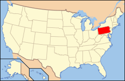 | |
|---|---|---|
| Lists by county |
| |
| Lists by city |
| |
| Other lists | ||
| ||
Municipalities and communities of Greene County, Pennsylvania, United States | ||
|---|---|---|
| Boroughs | | |
| Townships | ||
| CDPs | ||
| Unincorporated communities | ||
This article is issued from Wikipedia. The text is licensed under Creative Commons - Attribution - Sharealike. Additional terms may apply for the media files.