Clearfield County, Pennsylvania
Clearfield County is a sixth-class county located in the U.S. state of Pennsylvania. As of the 2010 census, the population was 81,642.[2] The county seat is Clearfield,[3] and the largest city is DuBois. The county was created in 1804 and later organized in 1822.[4]
Clearfield County | |
|---|---|
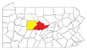
Location within the U.S. state of Pennsylvania | |
 Pennsylvania's location within the U.S. | |
| Coordinates: 41°00′N 78°28′W | |
| Country | |
| State | |
| Founded | January 29, 1822 |
| Seat | Clearfield |
| Largest city | DuBois |
| Area | |
| • Total | 1,154 sq mi (2,990 km2) |
| • Land | 1,145 sq mi (2,970 km2) |
| Population | |
| • Estimate (2018) | 79,388 |
| • Density | 71/sq mi (27/km2) |
| Time zone | UTC−5 (Eastern) |
| • Summer (DST) | UTC−4 (EDT) |
| Congressional district | 15th |
| Website | www |
| Designated | September 17, 1982[1] |
Clearfield County comprises the DuBois, PA Micropolitan Statistical Area, which is also included in the State College-DuBois, PA Combined Statistical Area.
History
Clearfield County was formed by the Act of Assembly by the second Governor of Pennsylvania at the time, Thomas McKean on March 26, 1804. The county was created from parts of the already created counties of Huntingdon and Lycoming. The name for the county was most likely derived from the many cleared fields of the valleys surrounding Clearfield Creek and West Branch of the Susquehanna River, formed by the bison herds and also by old corn fields of prior Native Americans tribes.
Location of county government
The first board of county commissioners to the county were Roland Curtin, James Fleming and James Smith, all appointed by Governor McKean in 1805. The first act the commissioners did was to create a local government or seat of the newly created county. They came upon land owned at the time by Abraham Witmer at a village known as Chincleclamousche, named after the Native American chief of the Cornplanter's tribe of Senecas. Clearfield became the new name of the old village.
Early industry
The two major industries of the county in the mid-1800s until the early 1900s was lumber and coal. Lumber was still being floated down the West Branch of the Susquehanna up until 1917. Coal remains the main industry of the county to this day.
Clearfield County Conspiracy Trials
No case tried in the county has caused as much comment as the union conspiracy trials. In all there were fifty-six persons, primarily miners in the Houtzdale region, who were charged with conspiracy as organized strikers. The first case against John Maloney and fifty three others was tried in 1875, before a jury with Judge Orvis presiding. All were found guilty, although they seem to have been solely peacefully picketing.[5] Four were sentenced to one year's imprisonment, eight for six months, and sentences suspended as to the others. As every organized labor society in the USA was interested in the result, the events of the trial and verdict were telegraphed throughout the country[6] This proceeding was followed by the trial of the remaining two offenders who were union representatives, John Siney, and Xingo Parks. Siney was then the President of the Miners’ National Association (MNA). He came to Houtzdale and delivered an address of support for the union strike, for which he was arrested. Parks was an able organizer for the MNA. They were defended by US Senator Matthew H. Carpenter of Wisconsin. At trial Siney was acquitted, but Parks was found guilty of inciting unlawful assembly. He was sentenced to one year's imprisonment, but pardoned within a month from the time sentence was pronounced.[7] These cases led in the next year to a liberalization of the Pennsylvania conspiracy law, through amendment providing that only "force, threat, or menace of harm to person or property" should be considered illegal.[8]
Geography
According to the U.S. Census Bureau, the county has a total area of 1,154 square miles (2,990 km2), of which 1,145 square miles (2,970 km2) is land and 9.2 square miles (24 km2) (0.8%) is water.[9] It is the third-largest county in Pennsylvania by land area and fourth-largest by total area. The West Branch Susquehanna River flows through the county bisecting the county seat along the way.
The mountainous terrain of the county made traffic difficult for early settlers. Various Native American paths and trails crossing the area were used intermittently by settlers, invading armies, and escaped slaves travelling north along the Underground Railroad. A major feature located in Bloom Township, Pennsylvania within the county is known as Bilger's rocks and exhibits fine examples of exposed sandstone bedrock that was created during the formation of the Appalachian Mountains.
The shape of Clearfield County bears an amazing resemblance to that of the state of Arkansas.
Major highways
Adjacent counties
- Elk County (north)
- Cameron County (north)
- Clinton County (northeast)
- Centre County (east)
- Blair County (southeast)
- Cambria County (south)
- Indiana County (southwest)
- Jefferson County (west)
Climate
The county has a warm-summer humid continental climate (Dfb). Average monthly temperatures in DuBois range from 24.6 °F in January to 68.6 °F in July, while in Clearfield borough they range from 23.8 °F in January to 69.3 °F in July and in Osceola Mills they range from 24.4 °F in January to 69.1 °F in July.
Demographics
| Historical population | |||
|---|---|---|---|
| Census | Pop. | %± | |
| 1810 | 875 | — | |
| 1820 | 2,342 | 167.7% | |
| 1830 | 4,803 | 105.1% | |
| 1840 | 7,834 | 63.1% | |
| 1850 | 12,586 | 60.7% | |
| 1860 | 18,759 | 49.0% | |
| 1870 | 25,741 | 37.2% | |
| 1880 | 43,408 | 68.6% | |
| 1890 | 69,565 | 60.3% | |
| 1900 | 80,614 | 15.9% | |
| 1910 | 93,768 | 16.3% | |
| 1920 | 103,236 | 10.1% | |
| 1930 | 86,727 | −16.0% | |
| 1940 | 92,094 | 6.2% | |
| 1950 | 85,957 | −6.7% | |
| 1960 | 81,534 | −5.1% | |
| 1970 | 74,619 | −8.5% | |
| 1980 | 83,578 | 12.0% | |
| 1990 | 78,097 | −6.6% | |
| 2000 | 83,380 | 6.8% | |
| 2010 | 81,642 | −2.1% | |
| Est. 2018 | 79,388 | [10] | −2.8% |
| U.S. Decennial Census[11] 1790-1960[12] 1900-1990[13] 1990-2000[14] 2010-2017[2] | |||
As of the census[15] of 2000, there were 83,382 people, 32,785 households, and 22,916 families residing in the county. The population density was 73 people per square mile (28/km2). There were 37,855 housing units at an average density of 33 per square mile (13/km2). The racial makeup of the county was 97.40% White, 1.49% Black or African American, 0.12% Native American, 0.26% Asian, 0.01% Pacific Islander, 0.26% from other races, and 0.46% from two or more races. 0.56% of the population were Hispanic or Latino of any race. 22.9% were of German, 13.6% American, 10.2% English, 9.9% Irish, 9.1% Italian and 6.0% Polish ancestry.
There were 32,785 households out of which 29.70% had children under the age of 18 living with them, 56.60% were married couples living together, 9.30% had a female householder with no husband present, and 30.10% were non-families. 26.30% of all households were made up of individuals and 13.10% had someone living alone who was 65 years of age or older. The average household size was 2.44 and the average family size was 2.94.
In the county, the population was spread out with 22.70% under the age of 18, 7.70% from 18 to 24, 28.80% from 25 to 44, 23.90% from 45 to 64, and 16.90% who were 65 years of age or older. The median age was 39 years. For every 100 females there were 99.50 males. For every 100 females age 18 and over, there were 97.50 males.
Micropolitan Statistical Area
The United States Office of Management and Budget[16] has designated Clearfield County as the DuBois, PA Micropolitan Statistical Area (µSA). As of the 2010 census[17] the micropolitan area ranked 6th most populous in the State of Pennsylvania and the 65th most populous in the United States with a population of 81,642. Clearfield County is also a part of the State College-DuBois, PA Combined Statistical Area (CSA), which combines the populations of both Clearfield and Centre County areas, as well as the State College area. The Combined Statistical Area ranked 9th in the State of Pennsylvania and 125th most populous in the United States with a population of 235,632.
Politics and government
As of October 2014, there were 50,846 registered voters in Clearfield County.[18]
- Democratic: 21,565 (42.41%)
- Republican: 23,497 (46.21%)
- Libertarian: 272 (0.53%)
- No Party Affiliation: 2,492 (4.90%)
- Other parties: 3,020 (5.94%)
While the county registration tends to be evenly matched between Democrats and Republicans, the county trends Republican in statewide and federal elections. The last Democrat to win a majority in the county was Lyndon B. Johnson in 1964, while Jimmy Carter and Bill Clinton winning pluralities in the county, with the former by 88 votes. In 2006, Democrat Bob Casey Jr. received 55% of its vote when he unseated incumbent Republican US Senator Rick Santorum and Ed Rendell received 50.2% of the vote against Lynn Swann. Each of the three row-office statewide winners carried Clearfield in 2008.
| Year | Republican | Democratic | Third parties |
|---|---|---|---|
| 2016 | 72.2% 24,932 | 23.7% 8,200 | 4.1% 1,418 |
| 2012 | 63.3% 20,347 | 34.6% 11,121 | 2.0% 654 |
| 2008 | 54.9% 18,662 | 42.8% 14,555 | 2.4% 805 |
| 2004 | 60.0% 20,533 | 39.5% 13,518 | 0.5% 182 |
| 2000 | 58.8% 18,019 | 38.3% 11,718 | 2.9% 896 |
| 1996 | 44.9% 12,987 | 41.4% 11,991 | 13.7% 3,977 |
| 1992 | 37.5% 11,553 | 39.7% 12,247 | 22.9% 7,047 |
| 1988 | 53.5% 14,296 | 45.8% 12,235 | 0.7% 182 |
| 1984 | 60.6% 18,653 | 38.9% 11,963 | 0.5% 153 |
| 1980 | 54.3% 15,299 | 41.3% 11,647 | 4.4% 1,246 |
| 1976 | 49.2% 13,626 | 49.5% 13,714 | 1.3% 345 |
| 1972 | 63.5% 16,780 | 35.0% 9,246 | 1.5% 383 |
| 1968 | 49.6% 14,471 | 42.4% 12,369 | 8.0% 2,323 |
| 1964 | 37.0% 11,338 | 62.7% 19,211 | 0.3% 103 |
| 1960 | 57.0% 18,911 | 42.8% 14,212 | 0.2% 72 |
| 1956 | 57.5% 17,519 | 42.2% 12,852 | 0.3% 89 |
| 1952 | 54.3% 16,045 | 45.2% 13,376 | 0.5% 156 |
| 1948 | 50.0% 11,810 | 48.0% 11,347 | 2.1% 487 |
| 1944 | 50.2% 13,986 | 48.9% 13,617 | 0.8% 233 |
| 1940 | 46.3% 15,407 | 53.2% 17,705 | 0.5% 163 |
| 1936 | 40.3% 14,531 | 57.7% 20,799 | 2.0% 720 |
| 1932 | 46.5% 10,500 | 49.6% 11,209 | 3.9% 888 |
| 1928 | 67.3% 16,719 | 31.7% 7,870 | 1.1% 270 |
| 1924 | 60.3% 13,745 | 22.1% 5,027 | 17.6% 4,015 |
| 1920 | 52.3% 9,615 | 32.6% 5,987 | 15.2% 2,791 |
| 1916 | 42.7% 5,676 | 46.5% 6,180 | 10.9% 1,443 |
| 1912 | 11.8% 1,523 | 36.2% 4,670 | 52.0% 6,707 |
| 1908 | 51.7% 7,726 | 39.8% 5,954 | 8.5% 1,271 |
| 1904 | 64.1% 9,541 | 28.8% 4,291 | 7.0% 1,047 |
| 1900 | 53.6% 7,955 | 40.8% 6,066 | 5.6% 833 |
| 1896 | 51.0% 7,395 | 44.5% 6,460 | 4.5% 653 |
| 1892 | 40.7% 4,765 | 52.2% 6,108 | 7.1% 829 |
| 1888 | 44.5% 5,297 | 52.7% 6,266 | 2.8% 337 |
County commissioners
| Commissioners | Party | First Elected |
|---|---|---|
| David Glass | Democratic | 2019 |
| Antonio Scotto | Republican | 2015 |
| John Sobel | Republican | 2007 |
Other county offices
| Office | Official | Party | First Elected |
|---|---|---|---|
| Clerk of Courts and Prothonotary | Brian K. Spencer | Republican | 2013 |
| Controller | Charles Adamson | Republican | 2015 (appointed) |
| Coroner | Kim Shaffer Snyder | Republican | 2017 (appointed) |
| District Attorney | Ryan P. Sayers | Republican | 2019 |
| Recorder of Deeds and Register of Wills | Maurene Inlow | Republican | 2007 |
| Sheriff | Michael Churner | Republican | 2017 |
| Treasurer | Carol Fox | Democratic | 1998 (appointed) |
State Senate
| District | Senator | Party |
|---|---|---|
| 25 | Joseph B. Scarnati | Republican |
| 35 | Wayne Langerholc Jr. | Republican |
| 41 | Donald C. White | Republican |
State House of Representatives
| District | Representative | Party |
|---|---|---|
| 73 | Tommy Sankey | Republican |
| 75 | Matt Gabler | Republican |
United States House of Representatives
| District | Representative | Party |
|---|---|---|
| 15 | Glenn "G.T." Thompson | Republican |
United States Senate
| Senator | Party |
|---|---|
| Pat Toomey | Republican |
| Bob Casey | Democrat |
Correctional facilities
- Clearfield County Jail
- Quehanna Bootcamp
- SCI Houtzdale
- Moshannon Valley Correctional Center
Education
Colleges and universities
- Lock Haven University of Pennsylvania at Clearfield, Pennsylvania
- Pennsylvania State University at DuBois
Community, junior and technical colleges
- Clearfield County Career and Technology Center
- Triangle Tech
Public school districts
- Clearfield Area School District
- Curwensville Area School District
- DuBois Area School District (also in Jefferson County)
- Glendale School District (also in Cambria County)
- Harmony Area School District (also in Indiana County)
- Moshannon Valley School District
- Philipsburg-Osceola Area School District (also in Centre County)
- Purchase Line School District (also in Indiana County)
- West Branch Area School District (also in Clinton County)
Intermediate unit
- Central IU 10 - West Decatur
Correctional institution schools
- Quehanna Boot Camp - Karthaus
- SCI-Houtzdale - Houtzdale
- Clearfield County Jail-Clearfield
Private schools
- Butchers Run Amish School
- Clearfield Alliance Christian School
- DuBois Area Catholic Elementary School
- DuBois Area Catholic High School
- DuBois Christian Schools
- Golden Yoke School
- Milestones Achievement Center
- Mount Calvary Christian Academy
- New Story (DuBois)
- Otterbein Christian Academy
- Paint & Play School (DuBois)
- Scenic View School
- St Francis Grade School
- Weber Road School
Libraries
- Clearfield County Public Library - Curwensville
- Curwensville Public Library
- DuBois Public Library -
- Glendale Public Library - Coalport
- Joseph and Elizabeth Shaw Public Library - Clearfield
Recreation
There are two Pennsylvania state parks in Clearfield County.
- Parker Dam State Park
- S. B. Elliott State Park
Clearfield County is also home to the largest wild area in Pennsylvania, the Quehanna Wild Area. A culturally and historically significant natural formation of massive sandstone megaliths can be found at Bilger's rocks.
Camping
Lodging/Camping[20]
| Campground # | Name | Location | Campsites | Swimming | Fishing | Hunting |
|---|---|---|---|---|---|---|
| 2515 | Woodland Campground | Woodland | 70 | yes | yes | yes |
Hunting/fishing
Hunting[21]
| SGL# | Location | Hunting Area | Acreage | Species |
|---|---|---|---|---|
| 34 | Medix Run | Benezette, Covington, Girard, Goshen Townships | 8,000 | bear, deer, turkey |
| 77 | Clear Run | Sandy Township | 3,038 | bear, deer, rabbit, squirrel |
| 78 | Bigler | Bradford & Graham Townships | 721 | bear, deer, turkey |
| 87 | Irishtown | Bell & Penn Townships | 10,422 | deer, grouse, turkey |
| 90 | Goshen | Goshen & Lawrence Townships | 3,958 | bear, deer, turkey |
| 93 | Sabula | Union & Huston Townships | 4,876 | bear, deer, turkey |
| 94 | Lecontes Mills | Goshen & Lawrence Townships | 2,108 | bear, deer, turkey |
| 98 | Blue Ball (West Decatur) | Boggs & Decatur Townships | 1,172 | deer, rabbit, turkey |
Fishing
| Lake/stream | Location | Tributary of |
|---|---|---|
| Bear Run Reservoir | Pike Township | West Branch of the Susquehanna River |
| Chest Creek | Chest Township | West Branch of the Susquehanna River |
| Clearfield Reservoir | Pike Township | West Branch of the Susquehanna River |
| Curwensville Lake | Pike Township | West Branch of the Susquehanna River |
| DuBois Reservoir | Union Township near Home Camp | |
| Duck Marshes | northern Girard Township near Elk County line | |
| Irvona Reservoir | Chest Township | Clearfield Creek |
| Lake Sabula | Sandy Township near Sabula | |
| Laurel Run (Bennett Branch Sinnemahoning Creek) | Huston Township in Parker Dam State Park | Bennett Branch of Sinnemahoning Creek |
| Moose Creek Reservoir | Lawrence Township near Mt. Joy | West Branch of the Susquehanna River |
| Parker Lake | Huston Township in Parker Dam State Park | Bennett Branch of Sinnemahoning Creek |
| Penfield Reservoir | Huston Township near Hoovertown | Bennett Branch of Sinnemahoning Creek |
| Treasure Lake | Sandy Township Treasure Lake | |
| Tyler Reservoir | Huston Township near Tyler | Bennett Branch of Sinnemahoning Creek |
| West Branch of the Susquehanna River | Most of central & eastern Clearfield County including Mahaffey, Curwensville, and Clearfield | Susquehanna River |
Sporting
Golf
| Course # | Name | Location | Holes | Website |
|---|---|---|---|---|
| 3133 | Chetremon Golf Course | 2 miles north of Cherry Tree in Burnside Township Clearfield County | 10 | https://web.archive.org/web/20111117163225/http://www.chetremon.com/ |
| 3274 | Grandview Golf Club | 1 mile south of Lumber City | 18 | http://www.golfnow.com/course-directory/pennsylvania-golf-courses/curwensville-golf-courses/grandview-golf-club |
Communities
Under Pennsylvania law, there are four types of incorporated municipalities: cities, boroughs, townships, and, in at most two cases, towns. The following cities, boroughs and townships are located in Clearfield County:
City
Boroughs
- Brisbin
- Burnside
- Chester Hill
- Clearfield (county seat)
- Coalport
- Curwensville
- Falls Creek (mostly in Jefferson County)
- Glen Hope
- Grampian
- Houtzdale
- Irvona
- Mahaffey
- New Washington
- Newburg (also known as La Jose)
- Osceola Mills
- Ramey
- Troutville
- Wallaceton
- Westover
Townships
Census-designated places
Census-designated places are geographical areas designated by the U.S. Census Bureau for the purposes of compiling demographic data. They are not actual jurisdictions under Pennsylvania law. Other unincorporated communities, such as villages, may be listed here as well.
Unincorporated communities
Unincorporated areas are region of land that are not parts of any incorporated boroughs, cities, or towns.
- Helvetia
- Lumber City
- New Castle (Clearfield County) – in Decatur Township[22]
- Sylvan Grove
- Viola
Population ranking
The population ranking of the following table is based on the 2010 census of Clearfield County.[17]
† county seat
| Rank | City/Town/etc. | Population (2010 Census) | Municipal type |
|---|---|---|---|
| 1 | DuBois | 7,794 | City |
| 2 | † Clearfield | 6,215 | Borough |
| 3 | Treasure Lake | 3,861 | CDP |
| 4 | Curwensville | 2,542 | Borough |
| 5 | Sandy | 1,429 | CDP |
| 6 | Hyde | 1,399 | CDP |
| 7 | Osceola Mills | 1,141 | Borough |
| 8 | Falls Creek (mostly in Jefferson County) | 1,037 | Borough |
| 9 | Plymptonville | 981 | CDP |
| 10 | Chester Hill | 883 | Borough |
| 11 | Houtzdale | 797 | Borough |
| 12 | Oklahoma | 782 | CDP |
| 13 | Morrisdale | 754 | CDP |
| 14 | Irvona | 647 | Borough |
| 15 | Hawk Run | 534 | CDP |
| 16 | West Decatur | 533 | CDP |
| 17 | Coalport | 523 | Borough |
| 18 | Grassflat | 511 | CDP |
| 19 | Ramey | 451 | Borough |
| 20 | Brisbin | 411 | Borough |
| 21 | Bigler | 398 | CDP |
| 22 | Westover | 390 | Borough |
| 23 | Mahaffey | 368 | Borough |
| 24 | Grampian | 356 | Borough |
| 25 | Kylertown | 340 | CDP |
| 26 | Wallaceton | 313 | Borough |
| 27 | Allport | 264 | CDP |
| 28 | Troutville | 243 | Borough |
| 29 | Burnside | 234 | Borough |
| 30 | Glen Hope | 142 | Borough |
| 31 | Newburg | 92 | Borough |
| 32 | New Washington | 59 | Borough |
Notable people
- Mary Elizabeth Willson (1842–1906), gospel singer, singer, composer, evangelist
- Spencer T. Folmar (1989–present), film director and producer, only ‘movies’ made in Clearfield, PA. Inherited financial windfall from parents/family. Frequently cited as “Hollywood’s Worst Filmmaker”.
- Willie Adams, major league baseball pitcher (1912-1919)
- Howie Bedell, major league baseball player
- William Bigler (January 1, 1814 – August 9, 1880), American politician, 12th Governor of Pennsylvania from 1852 to 1855, later U.S. Senator for Pennsylvania from 1856 until 1861.
- Earl Caldwell, former reporter and columnist for The New York Times; first African-American to have a regular column in a major national newspaper. Central figure in a major Supreme Court case about the protection of journalists' sources. Currently hosts Pacifica's WBAI radio (New York City)
- Otto Eppers, cartoonist/illustrator who as part of a stunt successfully jumped off the Brooklyn Bridge at 17 years of age
- Howard Fargo, former member of the Pennsylvania House of Representatives (1981-2000)
- Anthony A. Mitchell, clarinetist, composer and conductor. Led the United States Navy Band from 1962-1968.
- Rembrandt Cecil Robinson (1924-1972) was a United States Navy officer (Rear admiral)[17]
- Edward Scofield, governor of Wisconsin (1897–1901)
- William Irvin Swoope, Republican member of the U.S. House of Representatives (1923–27)
- William A. Wallace, Democratic U.S. senator who served from 1875–81
- Powell Weaver, composer and organist
- Robert Leon Hall III, Modern Dance choreographer with numerous Broadway/Off-Broadway Credits, 3-time Tony Award nominee.
See also
References
- "PHMC Historical Markers Search" (Searchable database). Pennsylvania Historical and Museum Commission. Commonwealth of Pennsylvania. Retrieved January 25, 2014.
- "State & County QuickFacts". United States Census Bureau. Retrieved November 16, 2013.
- "Find a County". National Association of Counties. Archived from the original on May 31, 2011. Retrieved June 7, 2011.
- "Pennsylvania: Individual County Chronologies". Pennsylvania Atlas of Historical County Boundaries. The Newberry Library. 2008. Retrieved March 11, 2015.
- Witte, Edwin E., Early American Labor Cases, 35 Yale Law Journal 7, 1926, pp. 830
- Aldrich, Lewis Cass (ed.), History of Clearfield County, Pennsylvania : with illustrations and biographical sketches of some of its prominent men and pioneers, Mason:Syracuse, 1887, p.81
- Aldrich, Clearfield County, 1887, p. 81
- Witte, Labor Cases, p. 831
- "2010 Census Gazetteer Files". United States Census Bureau. August 22, 2012. Retrieved March 6, 2015.
- "Population and Housing Unit Estimates". Retrieved October 12, 2018.
- "U.S. Decennial Census". United States Census Bureau. Retrieved March 6, 2015.
- "Historical Census Browser". University of Virginia Library. Retrieved March 6, 2015.
- Forstall, Richard L., ed. (March 24, 1995). "Population of Counties by Decennial Census: 1900 to 1990". United States Census Bureau. Retrieved March 6, 2015.
- "Census 2000 PHC-T-4. Ranking Tables for Counties: 1990 and 2000" (PDF). United States Census Bureau. April 2, 2001. Retrieved March 6, 2015.
- "U.S. Census website". United States Census Bureau. Retrieved January 31, 2008.
- "Office of Management and Budget - The White House". Retrieved November 22, 2018.
- "2010 U.S. Census website". United States Census Bureau. Retrieved February 10, 2013.
- "Archived copy". Archived from the original on November 5, 2014. Retrieved November 5, 2014.CS1 maint: archived copy as title (link)
- Leip, David. "Dave Leip's Atlas of U.S. Presidential Elections". uselectionatlas.org. Retrieved November 22, 2018.
- "Archived copy". Archived from the original on December 23, 2012. Retrieved December 29, 2012.CS1 maint: archived copy as title (link)
- "Archived copy". Archived from the original on October 31, 2012. Retrieved December 29, 2012.CS1 maint: archived copy as title (link)
- "New Castle Populated Place Profile / Clearfield County, Pennsylvania Data". pennsylvania.hometownlocator.com. Retrieved November 22, 2018.
External links
| Wikimedia Commons has media related to Clearfield County, Pennsylvania. |
- History of Townships in Clearfield County, PA
- History of Clearfield County
- Clearfield County Fair
Municipalities and communities of Clearfield County, Pennsylvania, United States | ||
|---|---|---|
| City | ||
| Boroughs | ||
| Townships | ||
| CDPs | ||
| Unincorporated communities | ||
| Footnotes | ‡This populated place also has portions in an adjacent county or counties | |
| Authority control |
|
|---|