NISAR (satellite)
The NASA-ISRO Synthetic Aperture Radar (NISAR) mission is a joint project between NASA and ISRO to co-develop and launch a dual-frequency synthetic aperture radar on an Earth observation satellite. The satellite will be the first radar imaging satellite to use dual frequencies. It will be used for remote sensing, to observe and understand natural processes on Earth. For example, its right-facing instruments will study the Antarctic cryosphere.[7]
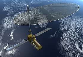 Artist's concept of the NASA-ISRO Synthetic Aperture Radar (NISAR) satellite in orbit. | |
| Mission type | Radar imaging |
|---|---|
| Operator | NASA / ISRO |
| Website | nisar www |
| Mission duration | 3 years[1][2] |
| Spacecraft properties | |
| Bus | I-3K[3] |
| Manufacturer | ISRO |
| Launch mass | 2,800 kg (6,200 lb)[4] |
| Power | 6,500 W |
| Start of mission | |
| Launch date | September 2022[5] |
| Rocket | GSLV Mk. II (4 meter fairing)[3] |
| Launch site | Satish Dhawan Space Center |
| Orbital parameters | |
| Reference system | Geocentric[1] |
| Regime | Low-Earth, Sun-synchronous[6] |
| Altitude | 747 kilometers (464 mi) |
| Inclination | 98.5° [6] |
| Transponders | |
| Band | Ka band L band |
With a total cost estimated at US$1.5 billion, NISAR is likely to be the world's most expensive Earth-imaging satellite.[8]
Overview
The NASA-ISRO Synthetic Aperture Radar, or NISAR satellite, will use advanced radar imaging to map the elevation of Earth's land and ice masses 4 to 6 times a month at resolutions of 5 to 10 meters.[9] It is designed to observe and measure some of the planet's most complex natural processes, including ecosystem disturbances, ice-sheet collapse, and natural hazards such as earthquakes, tsunamis, volcanoes and landslides.[10]
Under the terms of the agreement, NASA will provide the mission's L band synthetic aperture radar (SAR), a high-rate telecommunication subsystem for scientific data, GPS receivers, a solid-state recorder, and a payload data subsystem. ISRO will provide the satellite bus, an S band synthetic aperture radar, the launch vehicle, and associated launch services.[11]
All data from NISAR would be freely available 1 to 2 days after observation and within hours in case of emergencies like natural disasters.[9] Data collected from NISAR will reveal information about the evolution and state of Earth's crust, help scientists better understand our planet's natural processes and changing climate, and aid future resource and hazard management. The mission is a partnership between NASA and ISRO.[12]
The satellite will be three-axis stabilized. It will use a 12 m (39 ft) deployable mesh antenna and will operate on both the L and S microwave bands.[12] The aperture mesh reflector (antenna) will be supplied by Astro Aerospace, a Northrop Grumman company.[13]
The satellite will be launched from India aboard a Geosynchronous Satellite Launch Vehicle.[14][15][16] The orbit will be a Sun-synchronous, dawn-to-dusk type. The planned mission life is three years.[1] The project has passed the first stage of the design validation phase and has been reviewed and approved by NASA.[17]
ISRO's share of the project cost is about ₹788 crore (US$110 million), and NASA's share is about US$808 million.[15][16]
Payload
See also
- Earth observation satellite
- Indian Remote Sensing
- List of Indian satellites
- Seasat
References
- "Satellite Programme: NASA ISRO-Synthetic Aperture Radar". World Meteorological Organization. Archived from the original on 10 August 2014. Retrieved 2 July 2014.
- "Optimization of Debris Shields on the NISAR Mission's L-Band Radar Instrument" (PDF). conference.sdo.esoc.esa.int. ESA Space Debris Office. Retrieved 21 July 2017.
- "Overview of NISAR Mission and Airborne L & S SAR" (PDF). SAC.gov.in. Space Applications Centre, ISRO. Retrieved 23 November 2018.
- Neeck, Steven. "The NASA Earth Science Program and Small Satellites" (PDF). DLR.de. Retrieved 23 November 2018.
- Chaitanya, SV Krishna (4 August 2019). "Delighted that Chandrayaan-2 will explore moon's south pole: NASA chief scientist". The New Indian Express. Retrieved 11 September 2019.
The NASA-ISRO Synthetic Aperture Radar (NISAR) mission is proceeding well. The NASA and ISRO teams are working closely together toward launch in 2022.
- "NISAR Mission".
- Witze, Alexandra (2019-02-04). "Arctic scientists iced out by US–India radar mission". Nature. 566 (7742): 18. Bibcode:2019Natur.566...18W. doi:10.1038/d41586-019-00278-8. PMID 30723349.
- "NASA, ISRO jointly working on project NISAR". NASA/JPL (Press release). SAR Journal. 26 May 2017. Retrieved 11 September 2019.
- "Landslide Hazards to Infrastructure" (PDF). nisar.jpl.nasa.gov. 2017. Archived from the original (PDF) on 21 March 2019. Retrieved 21 March 2019.
- "NASA-ISRO SAR Mission (NISAR)". Jet Propulsion Laboratory. Retrieved 2 July 2014.
- "U.S., India to Collaborate on Mars Exploration, Earth-Observing Mission". NASA. 30 September 2014. Retrieved 8 October 2014.
- "NASA-ISRO Synthetic Aperature Radar". Jet Propulsion Laboratory. Retrieved 24 January 2017.
- White, AnnaMaria (30 October 2015). "NASA Jet Propulsion Laboratory Selects Northrop Grumman's Astro Aerospace for NISAR Reflector" (Press release). Northrop Grumman Corporation. GlobeNewswire. Retrieved 29 May 2019.
- Thakur, Vijainder K. (28 August 2015). "NASA-ISRO Synthetic Aperture Radar Radar Satellite (NI-SAR)". Indian Space Projects. Archived from the original on 8 December 2015. Retrieved 29 May 2019.
- "Rajya Sabha Q. No.2223, Session:243 "JOINT PROJECT BETWEEN NASA AND ISRO"" (PDF). Department of Space. 3 August 2017. Archived from the original (PDF) on 3 August 2017. Retrieved 29 May 2019.
- "Joint Project between NASA and ISRO". Press Information Bureau, Government of India. 3 August 2017. Retrieved 3 August 2017.
- "Isro's instrument design passes Nasa review". The Times of India. Retrieved 2 July 2014.
| Satellites |
|  | ||||||||||
|---|---|---|---|---|---|---|---|---|---|---|---|---|
| Space probes |
| |||||||||||
| Human spaceflight | ||||||||||||
| ||||||||||||