IRNSS-1G
IRNSS-1G was the seventh and final[2] of the Indian Regional Navigation Satellite System (IRNSS) series of satellites after IRNSS-1A, IRNSS-1B, IRNSS-1C, IRNSS-1D, IRNSS-1E and IRNSS-1F. This system of satellites will provide navigational services to the Indian region. The satellite was placed in geosynchronous orbit successfully on April 28, 2016 at 12:50–pm IST.[2]
| Mission type | Navigation |
|---|---|
| Operator | ISRO |
| COSPAR ID | 2016-027A |
| SATCAT no. | 41469 |
| Mission duration | 12 years |
| Spacecraft properties | |
| Spacecraft | IRNSS-1G |
| Spacecraft type | Satellite |
| Bus | I-1K |
| Manufacturer | ISRO Satellite Centre Space Applications Centre |
| Launch mass | 1,425 kilograms (3,142 lb) |
| Dry mass | 598 kilograms (1,318 lb) |
| Power | 1600 W |
| Start of mission | |
| Launch date | 12:50:00, April 28, 2016 (UTC+05:30) |
| Rocket | PSLV-XL C33 |
| Launch site | Satish Dhawan (First) |
| Contractor | ISRO |
| Orbital parameters | |
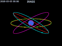
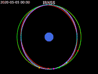
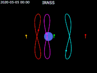
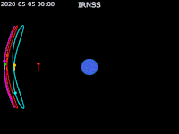
| Reference system | Geocentric |
| Regime | Geosynchronous Orbit (GSO) |
| Longitude | 129.429213 East |
| Perigee altitude | 35,780.961 km (22,233.258 mi)[1] |
| Apogee altitude | 35,796.200 km (22,242.727 mi)[1] |
| Inclination | 4.2637 |
| Period | 23:56:12.33 |
| Epoch | 17151.68965311 |
Launch
The satellite was launched from the First Launch Pad (FLP) of Satish Dhawan Space Centre, Sriharikota on board PSLV-C33.[2] The countdown of the launch had begun 51:30 hours before at 9:20 a.m. IST on 25 April.[3]
After the launch of IRNSS-1G the Indian government named the IRNSS system as NAVIC (Navigation Indian Constellation).
Specifications
The satellite is designed for 12 years of life.[3] It has a lift-off mass of 1,425 kilograms (3,142 lb) and dry mass of 598 kilograms (1,318 lb).[4] The ranging payload of IRNSS-1G consists of a C-band transponder (automatic receivers and transmitters of radio signals) which facilitates accurate determination of the range of the satellite.[5] It would operate in L-5 and S band spectrums and also has a Rubidium atomic clock.[6] Special thermal control systems are used for key components like this clock. Two panels of solar cells are used to generate 1660W of energy and one Lithium-ion 90A-hr battery is used.[4] The satellite is placed in an orbit at an altitude of 35,788.5 kilometres (22,237.9 mi) at 129.5 deg East longitude.[4][7] It cost approximately ₹125 crore (US$18 million).[8]
The "XL" version of PSLV was used with six strap-ons for the launch. Each strap-on used 12 metric tons (12 long tons; 13 short tons) of propellant. ISRO has successfully used PSLV 34 times and the XL version 12 times before the launch of IRNSS-1G.[9]
See also
- Communication-Centric Intelligence Satellite (CCI-Sat)
- GPS-aided geo-augmented navigation (GAGAN)
- Satellite navigation
References
- "NORAD Catalog Number 41469". NORAD. Retrieved 2 June 2017.
- "India launches seventh navigation satellite, to get its own GPS". The Hindu. 28 April 2016. Retrieved 28 April 2016.
- PTI (26 April 2016). "Countdown for IRNSS-1G launch begins at Sriharikota". The Hindu. Retrieved 28 April 2016.
- "PSLV-C33 - IRNSS-1G Specifications" (PDF). ISRO. Retrieved 28 April 2016.
- "'Isro launches rocket carrying India's seventh navigation satellite'". Business Standard. 28 April 2016. Retrieved 28 April 2016.
- "IRNSS-1G". ISRO. Retrieved 28 April 2016.
- Sangeeta Ojha (28 April 2016). "India's own navigation satellite IRNSS-1G launched: All you need to know about it". India Today. Retrieved 28 April 2016.
- Vanita Srivastava (1 May 2016). "IRNSS: Desi GPS to liberate India from dependence on US, Russia". Economic Times. Retrieved 2 May 2016.
- "PSLV-C33/IRNSS-1G". ISRO. Retrieved 28 April 2016.
External links
| Satellites | ||
|---|---|---|
| Related articles | ||
| Satellites |
|  | ||||||||||
|---|---|---|---|---|---|---|---|---|---|---|---|---|
| Space probes |
| |||||||||||
| Human spaceflight | ||||||||||||
| ||||||||||||