Earth Observing System
The Earth Observing System (EOS) is a program of NASA comprising a series of artificial satellite missions and scientific instruments in Earth orbit designed for long-term global observations of the land surface, biosphere, atmosphere, and oceans. The satellite component of the program was launched in 1997. The program is centerpiece of NASA's Earth Science Enterprise (ESE).
Mission list with launch dates
NASA Earth Science Division Operating Missions as of 2 February 2015
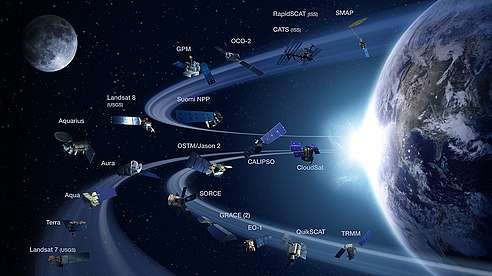
This animation shows the orbits of NASA's 2011 fleet of Earth remote sensing observatories
| Active mission | Completed mission |
| Satellite | Launch date | Designed life | Completion date | Launch site | Agency | Mission description |
|---|---|---|---|---|---|---|
| ACRIMSAT | 20 December 1999 | 30 July 2014 | Vandenberg | NASA | Study Total Solar Irradiance | |
| ADEOS I | 17 August 1996 | 30 June 1997 | Tanegashima | NASA / NASDA | Study wind scattering and map the ozone layer | |
| ADEOS II (Midori II) | 14 December 2002 | 24 October 2003 | Tanegashima | JAXA / NASA | Monitor the water and energy cycle as a part of the global climate system | |
| ATS-3 | 7 December 1966 | 3 years | 1 December 1978[1] | Cape Canaveral | NASA | Weather observation |
| ATLAS-1 | 24 March 1992 | 2 April 1992 | NASA | Unravel man's impact on the environment | ||
| CHAMP | 15 July 2000 | 5 years | 19 September 2010 | Plesetsk 132/1 | GFZ | Atmospheric and ionospheric research |
| CRRES | 25 July 1990 | 3 years | 12 October 1991 | Cape Canaveral | NASA | Investigate fields, plasmas, and energetic particles inside the magnetosphere |
| DE 1 and DE 2 | 3 August 1981 | 28 February 1991 and 19 February 1983 | Vandenberg | NASA | Investigate the interactions between plasmas in the magnetosphere and those in the ionosphere | |
| ERBS | 5 October 1984 | 2 years | 14 October 2005 | Cape Canaveral | NASA | Study the Earth's radiation budget and stratospheric aerosol and gases |
| ESSA program | 1966–1969 | Cape Canaveral | ESSA / NASA | Provide cloud-cover photography | ||
| ERS-1 | 17 July 1991 | March 2000 | Kourou | ESA | Measure wind speed and direction and ocean wave parameters | |
| SeaWiFS | 1 August 1997 | 1 August 2002 | 11 December 2010 | Vandenberg | GeoEye / NASA | Provide quantitative data on global ocean bio-optical properties |
| TRMM | 27 November 1997 | 27 November 2000 | 9 April 2015 | Tanegashima | NASA / JAXA | Monitor and study tropical rainfall |
| Landsat 7 | 15 April 1999 | Active | Vandenberg | NASA | Supply the world with global land surface images | |
| QuikSCAT | 19 June 1999 | 19 June 2002 | 19 November 2009 | Vandenberg | NASA / JPL | Acquire global radar cross-sections and near-surface vector winds |
| Terra (EOS-AM) | 18 December 1999 | 18 December 2005 | Active | Vandenberg | NASA | Provide global data on the state of the atmosphere, land, and oceans |
| NMP/EO-1 | 21 November 2000 | 30 March 2017 | Vandenberg | NASA | Demonstrate new technologies and strategies for improved Earth observations | |
| Jason 1 | 7 December 2001 | 1 July 2013 | Vandenberg | NASA / CNES | Provide information on ocean surface current velocity and heights | |
| Meteor 3M-1/Sage III | 10 December 2001 | 6 March 2006 | Baikonur | Roscosmos | Provide accurate, long-term measurements of ozone, aerosols, water vapor, and other key parameters of Earth's atmosphere | |
| GRACE | 17 March 2002 | 27 October 2017 | Plesetsk Cosmodrome | NASA / DLR | Measure Earth's mean and time-variable gravity field | |
| Aqua | 4 May 2002 | 4 May 2008 | Active | Vandenberg | NASA | Collect water information in the Earth system |
| ICESat | 12 January 2003 | 14 August 2010 | Vandenberg | NASA | Measuring ice sheet mass balance, cloud and aerosol heights, and land topography and vegetation characteristics | |
| SORCE | 25 January 2003 | Active | Cape Canaveral | NASA | Improve our understanding of the Sun | |
| Aura | 15 July 2004 | 15 July 2010 | Active | Vandenberg | NASA | Investigate questions about ozone trends, air-quality changes and their linkage to climate change |
| CloudSat | 28 April 2006 | 28 April 2009 | Active | Vandenberg | NASA | Provide the first direct, global survey of the vertical structure and overlap of cloud systems and their liquid and ice-water contents |
| CALIPSO | 28 April 2006 | Active | Vandenberg | NASA / CNES | Improve understanding of the role aerosols and clouds play in regulating the Earth's climate | |
| SMAP | 31 January 2015 | 31 May 2018 | Active | Vandenberg | NASA | Measure surface soil moisture and freeze-thaw state |
| OCO-2 | 2 July 2014 | 2 July 2019 | Active | Vandenberg | NASA | Provide space-based global measurements of atmospheric carbon dioxide |
| Aquarius | 10 June 2011 | 17 June 2015 [2] | Vandenberg | NASA / CONAE | Map the spatial and temporal variations of sea surface salinity | |
| Landsat 8 | 11 February 2013 | 11 February 2018 | Active | Vandenberg | NASA / USGS | Supply the world with global land surface images |
See also
- Atmospheric Chemistry Observational Databases
- Geoinformatics
- Earth Observing System Data and Information System (EOSDIS) – provides end-to-end capabilities for managing NASA's Earth science data
- A-train (satellite constellation)
- Algorithm Theoretical Basis Documents
References
- "ATS | Science Mission Directorate". science.nasa.gov. Retrieved 27 October 2016.
- Team, Lisa Taylor, Aquarius EPO. "NASA Aquarius Mission – Mission Status & Event Report". aquarius.umaine.edu.
External links
This article is issued from Wikipedia. The text is licensed under Creative Commons - Attribution - Sharealike. Additional terms may apply for the media files.