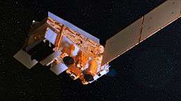
Suomi NPP
The Suomi National Polar-orbiting Partnership or Suomi NPP, previously known as the National Polar-orbiting Operational Environmental Satellite System Preparatory Project (NPP) and NPP-Bridge, is a weather satellite operated by the United States National Oceanic and Atmospheric Administration. It was launched in 2011 and continues to operate.
 Suomi NPP | |
| Mission type | Meteorology |
|---|---|
| Operator | NASA / NOAA / DoD |
| COSPAR ID | 2011-061A |
| SATCAT no. | 37849 |
| Mission duration | 5 years |
| Spacecraft properties | |
| Bus | BCP-2000 |
| Manufacturer | Ball Aerospace |
| Launch mass | 2,128 kilograms (4,691 lb)[1] |
| Dry mass | 1,400 kilograms (3,100 lb)[2] |
| Payload mass | 464 kilograms (1,023 lb)[2] |
| Dimensions | 1.3 m x 1.3 m x 4.2 m [2] |
| Start of mission | |
| Launch date | 28 October 2011, 09:48:01.828 UTC[3] |
| Rocket | Delta II 7920-10[4] D357 |
| Launch site | Vandenberg SLC-2W |
| Contractor | United Launch Alliance |
| Orbital parameters | |
| Reference system | Geocentric |
| Regime | Sun-synchronous |
| Semi-major axis | 7,204.0 kilometers (4,476.4 mi)[5] |
| Perigee altitude | 833.7 kilometers (518.0 mi)[5] |
| Apogee altitude | 834.3 kilometers (518.4 mi)[5] |
| Inclination | 98.7 degrees[5] |
| Period | 101.44 minutes[5] |
| Epoch | 25 January 2015, 00:35:06 UTC[5] |
National Polar-orbiting Operational Environmental Satellite System Preparatory Project | |
Suomi was originally intended as a pathfinder for the NPOESS program, which was to have replaced NOAA's Polar Operational Environmental Satellites and the U.S. Air Force's Defense Meteorological Satellite Program. Suomi was launched in 2011 after the cancellation of NPOESS to serve as a stop-gap between the POES satellites and the Joint Polar Satellite System which will replace them. Its instruments provide climate measurements that continue prior observations by NASA's Earth Observing System.
The satellite is named after Verner E. Suomi, a meteorologist at the University of Wisconsin–Madison. The name was announced on January 24, 2012, three months after the satellite's launch.[6][7]
The satellite was launched from Space Launch Complex 2W at Vandenberg Air Force Base in California by a United Launch Alliance Delta II 7920-10C on October 28, 2011. The satellite was placed into a sun-synchronous orbit 824 km (512 miles) above the Earth.[8]
History
NPOESS Preparatory Project (NPP) is intended to bridge the gap between old EOS and new systems by flying new instruments, on a new satellite bus, using a new ground data network.[9] Originally planned for launch five years earlier as a joint NASA/NOAA/DOD project, NPP was to be a pathfinder mission for the larger National Polar-orbiting Operational Environmental Satellite System until DOD participation in the larger project was dissolved. The project continued as a civilian weather forecasting replacement for the NOAA Polar Operational Environmental Satellites (POES) series, and ensured continuity of climate measurements begun by NASA's Earth Observing System.[10]
The spacecraft was launched 28 October 2011 from Vandenberg Air Force Base via a Delta II in the 7920-10 configuration (Extra Extended Long Tank with RS-27A engine first stage, 9 GEM-40 solid rocket motors, type 2 second stage with Aerojet AJ10 engine, no 3rd stage and a 10-meter fairing).[4][11][12] Additionally, the rocket deployed four CubeSats as a part of NASA ELaNa III manifest.
The VIIRS sensor on board the spacecraft acquired its first measurements of Earth on November 21, 2011.[13]
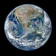
NASA also released a high resolution blue marble image of the Earth showing most of North America, which was created by NASA oceanographer Norman Kuring using data obtained on January 4, 2012 by the Visible Infrared Imager Radiometer Suite, one of five imaging systems aboard the satellite. That date was chosen because it was a fairly sunny day in most of North America.[8]
Status and future
As of August 2018 (beyond the initial 5-year mission) the spacecraft continues to operate.[14]
Instrumentation and capabilities
The Suomi NPP is the first in a new generation of satellites intended to replace the Earth Observing System satellites, which were launched from 1997 to 2011. The satellite orbits the Earth about 14 times each day. Its five imaging systems include:
- Advanced Technology Microwave Sounder (ATMS),[15] a microwave radiometer which will help create global moisture and temperature models
- Cross-track Infrared Sounder (CrIS),[16] a Michelson interferometer to monitor moisture and pressure
- Ozone Mapping and Profiler Suite (OMPS),[17] a group of imaging spectrometers to measure ozone levels, especially near the poles
- Visible Infrared Imaging Radiometer Suite (VIIRS),[18] a 22-band radiometer to collect infrared and visible light data to observe weather, climate, oceans, nightlight, wildfires, movement of ice, and changes in vegetation and landforms
- Clouds and the Earth's Radiant Energy System (CERES), a radiometer to detect thermal radiation, including reflected solar radiation and thermal radiation emitted by the Earth[19]
Gallery
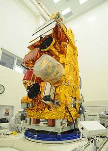
 Delta II rocket carrying NPP
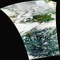 First image acquired by the VIIRS sensor.
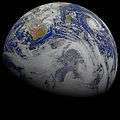 This composite image of southern Africa and the surrounding oceans was captured by six orbits of the satellite.
References
- "NPP NASA Facts" (PDF). NASA. Archived from the original (PDF) on 2013-02-15. Retrieved February 8, 2017.
- "Suomi NPP (National Polar-orbiting Partnership) Mission". eoPortal. Retrieved February 8, 2017.
- @NASAKennedy. "#NPP's official liftoff time was 2:48:01.828 a.m. PDT". Twitter. Retrieved 2013-08-17.
- NPP Satellite Reaches Orbit | AVIATION WEEK
- "NPP Satellite details 2011-061A NORAD 37849". N2YO. 25 January 2015. Retrieved 25 January 2015.
- Gran, Rani; Steve Cole (January 25, 2012). "NASA Renames Earth-Observing Mission in Honor of Satellite Pioneer". Suomi NPP. NASA. Retrieved January 29, 2012.
- Herzog, Karen (January 26, 2012). "Satellite renamed to honor UW's Suomi". Milwaukee Journal Sentinel. Milwaukee. Retrieved January 29, 2012.
- Netburn, Deborah (January 26, 2012). "The making of NASA's super hi-res blue marble Earth image". Los Angeles Times. Los Angeles. Retrieved January 29, 2012.
- "NPP Mission". NASA. Retrieved 15 August 2011.
- http://www.nasa.gov/home/hqnews/2010/sep/HQ_C10-058_JPSS-1_Spacecraft.txt
- History of the Delta Launch Vehicle: Description and Designations
- "NPP weather and climate satellite launches". BBC News. October 28, 2011.
- VIIRS First Light
- Rumbia. 17 Aug 2018
- Muth, C.; P.S. Lee; J. C. Shiue; W. Allan Webb (27 December 2004). "Advanced Technology Microwave Sounder on NPOESS and NPP". Geoscience and Remote Sensing Symposium, 2004. IGARSS '04. Proceedings. 2004 IEEE International. 4: 2454–2458. doi:10.1109/IGARSS.2004.1369789.
- "Cross-track Infrared Sounder (CrIS)". NASA. Retrieved 15 August 2011.
- "POLAR-ORBITING ENVIRONMENTAL SATELLITES: Information on Program Cost and Schedule Changes: GAO-04-1054". GAO. 2004.
- "Visible/Infrared Imager Radiometer Suite (VIIRS)". Raytheon. Retrieved 15 August 2011.
- "Spacecraft and Instruments". Suomi NPP. NASA. Archived from the original on April 13, 2012. Retrieved January 29, 2012.
External links
| Wikimedia Commons has media related to Suomi NPP. |
- Official website
- Mission page (NASA)
- Press kit (NASA)
- Press kit (Ball Aerospace)
- Brochure (NASA)