Cartosat-2A
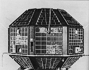
Cartosat-2A is an Earth observation satellite in a sun-synchronous orbit and the third of the Cartosat series of satellites. The satellite is the thirteenth satellite in the Indian Remote Sensing (IRS) satellite series to be built, launched and maintained by the Indian Space Research Organisation (ISRO).
| Mission type | Earth observation | ||||
|---|---|---|---|---|---|
| Operator | Indian Space Research Organisation (ISRO) | ||||
| COSPAR ID | 2008-021A | ||||
| SATCAT no. | 32783 | ||||
| Website | https://www.isro.gov.in/Spacecraft/cartosat-%E2%80%93-2a | ||||
| Mission duration | 5 years (planned) 12 years, 1 month, 29 days (elapsed) | ||||
| Spacecraft properties | |||||
| Bus | IRS-2[1] | ||||
| Manufacturer | Indian Space Research Organisation (ISRO) | ||||
| Launch mass | 690 kg [2][3] | ||||
| Dry mass | 626 kg [3] | ||||
| Power | 900 watts [2][3] | ||||
| Start of mission | |||||
| Launch date | 28 April 2008 at 03:54:00 UTC[4] | ||||
| Rocket | PSLC-C9[5] | ||||
| Launch site | Satish Dhawan, SLP[5] | ||||
| Contractor | Indian Space Research Organisation (ISRO) | ||||
| Orbital parameters | |||||
| Reference system | Geocentric | ||||
| Regime | Sun-synchronous | ||||
| Perigee altitude | 616 km | ||||
| Apogee altitude | 637 km | ||||
| Inclination | 98.0° | ||||
| Period | 97.3 minutes | ||||
| Epoch | 28 April 2008 | ||||
| |||||
Cartosat series | |||||
Description
It was launched by the PLSV-C9 on 28 April 2008 along with the 87 kg Indian Mini Satellite (IMS-1) and eight nano research satellites belonging to research facilities.
The CanX-2 and the CanX-6 of Canada, the AAUSAT-2 of Denmark, the Compass-1 and the Rubin-8 of Germany, the CUTE-1.7 of Japan, and the Delfi-C3 of the Netherlands.[6]
The IMS-1 satellite is a Ministry of Defence mission for the Government of India.[7] It is a dedicated satellite for the Indian Armed Forces which is in the process of establishing an Aerospace Command.[8]
The satellite carries a panchromatic (PAN) camera capable of taking black-and-white pictures in the visible region of electromagnetic spectrum. The highly agile Cartosat-2A can be steered up to 45° along as well as across the direction of its movement to facilitate imaging of any area more frequently. The satellite's health is continuously monitored from the Spacecraft Control Centre at Bangalore with the help of ISTRAC network of stations at Bangalore, Lucknow, Mauritius, Bearslake in Russia, Biak in Indonesia and Svalbard in Norway.[9]
See also
References
- Krebs, Gunter. "Cartosat 2, 2A, 2B, 2C, 2D, 2E". Gunter's Space Page. Retrieved 19 June 2017.
- "Cartosat-2A". Indian Space Research Agency. 28 April 2008. Retrieved 19 June 2017.
- "Satellite: CartoSat-2A". World Meteorological Organization. Retrieved 19 June 2017.
- "Cartosat 2A - Trajectory Details". National Space Science Data Center. NASA. Retrieved 19 June 2017.

- "PSLV C9/Cartosat 2A/IMS-1 Mission Brochure" (PDF). Indian Space Research Organisation. Retrieved 19 June 2017.
- India in multi-satellite launch
- "The Hindu Business Line: ISRO arm may get more satellite launch contracts, by K. Pichumani". Archived from the original on 11 September 2009. Retrieved 15 April 2008.
- "NDTV.com: India to launch first military satellite in August". 10 June 2008. Archived from the original on 2 May 2008. Retrieved 18 July 2010.
- PSLV Successfully Launches Ten Satellites Archived 1 May 2008 at the Wayback Machine
External links
| Satellites |
|  | ||||||||||
|---|---|---|---|---|---|---|---|---|---|---|---|---|
| Space probes |
| |||||||||||
| Human spaceflight | ||||||||||||
| ||||||||||||
Earth reconnaissance satellites (excluding Russia and the United States) | |||||||
|---|---|---|---|---|---|---|---|
| Canada |
| ||||||
| China |
| ||||||
| France |
| ||||||
| Germany |
| ||||||
| India |
| ||||||
| Israel |
| ||||||
| Italy |
| ||||||
| Japan |
| ||||||
| South Korea |
| ||||||
| Spain |
| ||||||
| Turkey |
| ||||||
| United Kingdom |
| ||||||