Cartosat-2F
Cartosat-2F is the eight satellite in the Cartosat-2 series. It is an Earth observation satellite launched on the PSLV-C40 mission by the Indian Space Research Organisation.[2] The PSLV-C40 launch was initially placed on hiatus following failures with the nose cone and satellite deployment systems of PSLV-C39, but was cleared to launch once these issues were resolved.[3] It was launched at 09:29 local time from First Launch Pad at Sriharikota Range on January 12, 2018,[4] the third of the series to be launched within a year.[5] After 16 minutes and 37, Cartosat-2F was separated from the launch vehicle, and the ISRO Telemetry, Tracking and Command Network took control of the satellite for maneuvers to its desired orbit.[4] The launch also marked the 100th satellite successfully put into orbit by the ISRO.[6]
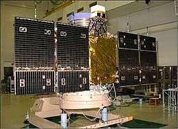 CartoSat 2 (Image Credit ISRO) | |
| Mission type | Reconnaissance |
|---|---|
| Operator | IRSO[1] |
| COSPAR ID | 2018-004A |
| SATCAT no. | 43111 |
| Website | Cartosat 2 Series Satellite |
| Mission duration | Planned: 5 years Elapsed: 2 years, 5 months, 10 days |
| Spacecraft properties | |
| Spacecraft type | Earth Observation |
| Manufacturer | ISRO |
| Launch mass | 710 Kg |
| Power | 986 Watts |
| Start of mission | |
| Launch date | 03:59:00, 12 January 2018 (UTC) |
| Rocket | PSLV-C40 |
| Launch site | Satish Dhavan Space Center, Sriharikotta, India |
| Contractor | ISRO |
| Orbital parameters | |
| Reference system | Circular polar Sun Synchronous |
| Regime | Sun-synchronous orbit |
| Inclination | 97.47 Degree |
| Period | 94.72 Minute |
Cartosat series | |
Originally, Cartosat-2E was published as the last Cartosat-2 satellite to be launched, as Cartosat-3 series spacecraft were scheduled to launch in 2018. Cartosat-2F was first listed on launch schedules as Cartosat-2ER, a name possibly indicating it was originally a replica of Cartosat-2E to be used as a spare.[7]
Like other satellites in the series, Cartosat-2F was built on an IRS-2 bus. It uses reaction wheels, magnetorquers, and hydrazine-fueled reaction control thrusters for stability. It has a design service life of five years.[5] Cartosat-2F has two main remote sensing instruments, a panchromatic camera called PAN and a four channel visible/near infrared radiometer called HRMX.[2]
The first image returned by the mission, on January 15, 2018; was of Holkar Stadium and the surrounding community in Indore, Madhya Pradesh.[8] The PAN camera is designed to have a spatial resolution less than one meter and a swath width of ten kilometers.[9]
References
- "PSLV C40 • Cartosat-2F". Spaceflight101. Retrieved 2 March 2019.
- "Satellite: CartoSat-2F". World Meteorological Organization.
- "PSLV all set to ferry 31 satellites on January 12". The Hindu. 10 January 2018. Retrieved 1 March 2019.
- "PSLV Successfully Launches 31 Satellites in a Single Flight - ISRO". www.isro.gov.in. ISRO. Retrieved 1 March 2019.
- "Cartosat 2F". nssdc.gsfc.nasa.gov. NASA. Retrieved 28 February 2019.
- "ISRO launches 100th satellite Cartosat-2 Series | Tehelka". tehelka.com. Tehelka. Retrieved 28 February 2019.
- Graham, William (11 January 2018). "India's PSLV successfully launches Cartosat-2F – NASASpaceFlight.com". nasaspaceflight.com. Retrieved 1 March 2019.
- K R, Rahul (18 January 2018). "Cartosat-2F first image stunningly sharper than Google Map". International Business Times, Singapore Edition. Retrieved 28 February 2019.
- Krebs, Gunter. "Cartosat 2, 2A, 2B, 2C, 2D, 2E, 2F". Gunter's Space Page. Retrieved 28 February 2019.
| 1990s | ||
|---|---|---|
| 2000s | ||
| 2010s |
| |
| Satellites |
|  | ||||||||||
|---|---|---|---|---|---|---|---|---|---|---|---|---|
| Space probes |
| |||||||||||
| Human spaceflight | ||||||||||||
| ||||||||||||
Earth reconnaissance satellites (excluding Russia and the United States) | |||||||
|---|---|---|---|---|---|---|---|
| Canada |
| ||||||
| China |
| ||||||
| France |
| ||||||
| Germany |
| ||||||
| India |
| ||||||
| Israel |
| ||||||
| Italy |
| ||||||
| Japan |
| ||||||
| South Korea |
| ||||||
| Spain |
| ||||||
| Turkey |
| ||||||
| United Kingdom |
| ||||||