Cartosat-2E
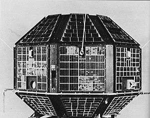
Cartosat-2E is an Earth observation satellite developed by the Indian Space Research Organisation (ISRO), and is the seventh in the Cartosat series.[4] It is designed to collect high-resolution, large-scale imagery for use in urban planning, infrastructure development, utilities planning, and traffic management.[5]
| Mission type | Earth observation | ||||||
|---|---|---|---|---|---|---|---|
| Operator | ISRO | ||||||
| COSPAR ID | 2017-036C | ||||||
| SATCAT no. | 42767 | ||||||
| Website | PSLV-C38 webpage | ||||||
| Mission duration | Planned: 5 years Elapsed: 3 years, 3 days | ||||||
| Spacecraft properties | |||||||
| Bus | IRS-2[1] | ||||||
| Manufacturer | ISRO | ||||||
| Launch mass | 712 kg (1,570 lb)[2] | ||||||
| Power | 986 watts[2] | ||||||
| Start of mission | |||||||
| Launch date | 23 June 2017, 03:59 UTC[3] | ||||||
| Rocket | PSLV-XL C38[3] | ||||||
| Launch site | Satish Dhawan FLP[2] | ||||||
| Contractor | ISRO | ||||||
| Orbital parameters | |||||||
| Reference system | Geocentric | ||||||
| Regime | Sun-synchronous | ||||||
| Perigee altitude | 505 km (314 mi) | ||||||
| Apogee altitude | 505 km (314 mi) | ||||||
| Inclination | 97.44° | ||||||
| Period | 94.72 minutes | ||||||
| Epoch | Planned[2] | ||||||
| |||||||
Cartosat series | |||||||
The satellite was launched on 23 June 2017, along with NIUSAT and 29 other satellites, aboard a PSLV-XL rocket from the Satish Dhawan Space Centre First Launch Pad.[3][6] With a mass of 712 kilograms (1,570 lb), it is deployed into a 505-kilometre (314 mi) Sun-synchronous orbit for a five-year primary mission.[2] India has allocated ₹160 crore (US$25 million in 2017) for the project.[7]
Payloads
Cartosat-2E carries two primary instruments: the Panchromatic Camera (PAN) and the High-Resolution Multi-Spectral radiometer (HRMX). PAN is capable of taking panchromatic (black and white) photographs in a selected portion of the visible and near-infrared spectrum (0.50–0.85 µm) at a resolution of 65 centimetres (26 in).[8] HRMX is a four-channel radiometer sensitive across the entire visible spectrum and part of the near-infrared spectrum (0.43–0.90 µm) at a resolution of 2 metres (6.6 ft).[9]
See also
References
- Krebs, Gunter. "Cartosat 2, 2A, 2B, 2C, 2D, 2E". Gunter's Space Page. Retrieved 19 June 2017.
- "PSLV-C38: Cartosat-2 Series Satellite Brochure" (PDF). Indian Space Research Organisation. Retrieved 19 June 2017.
- Graham, William (22 June 2017). "PSLV rocket launches Cartosat 2E and 30 small sats". NASASpaceFlight.com. Retrieved 23 June 2017.
- "Cartosat-2E". World Meteorological Organization. Retrieved 9 September 2016.
- "ISRO anticipates high resolution images from Cartosat satellites". The Hindu. 8 May 2016. Retrieved 9 September 2016.
- Prasannal, Laxmi (15 June 2017). "ISRO to launch 'Cartosat 2E' on board PSLV-C38 on June 23". The Times of India. Times News Network. Retrieved 19 June 2017.
- "Space Projects Initiated/Pending Completion". Press Information Bureau, Government of India. 24 July 2014. Retrieved 9 September 2016.
- "Instrument: PAN (CartoSat 2C/D)". World Meteorological Organization. Retrieved 19 June 2017.
- "Instrument: HRMX". World Meteorological Organization. Retrieved 19 June 2017.
| Satellites |
|  | ||||||||||
|---|---|---|---|---|---|---|---|---|---|---|---|---|
| Space probes |
| |||||||||||
| Human spaceflight | ||||||||||||
| ||||||||||||
Earth reconnaissance satellites (excluding Russia and the United States) | |||||||
|---|---|---|---|---|---|---|---|
| Canada |
| ||||||
| China |
| ||||||
| France |
| ||||||
| Germany |
| ||||||
| India |
| ||||||
| Israel |
| ||||||
| Italy |
| ||||||
| Japan |
| ||||||
| South Korea |
| ||||||
| Spain |
| ||||||
| Turkey |
| ||||||
| United Kingdom |
| ||||||