Landsat 7
Landsat 7 is the seventh satellite of the Landsat program. Launched on 15 April 1999, Landsat 7's primary goal is to refresh the global archive of satellite photos, providing up-to-date and cloud-free images. The Landsat Program is managed and operated by the United States Geological Survey, and data from Landsat 7 is collected and distributed by the USGS. The NASA WorldWind project allows 3D images from Landsat 7 and other sources to be freely navigated and viewed from any angle. The satellite's companion, Earth Observing-1, trailed by one minute and followed the same orbital characteristics, but in 2011 its fuel was depleted and EO-1's orbit began to degrade.[2] Landsat 7 was built by Lockheed Martin Space Systems.
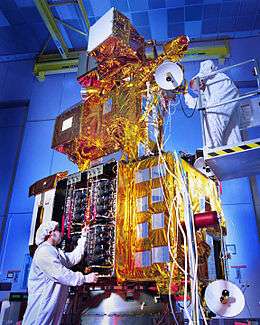 Landsat 7 before launch | |
| Mission type | Earth imaging |
|---|---|
| Operator | USGS / NASA |
| COSPAR ID | 1999-020A |
| SATCAT no. | 25682 |
| Mission duration | 5 years (planned) 21+ years (achieved) |
| Spacecraft properties | |
| Bus | TIROS-N |
| Manufacturer | Lockheed Martin Space Systems |
| Launch mass | 1973 kg |
| Dimensions | 4.04 metre long 2.74 metre diameter |
| Power | 1550 watts |
| Start of mission | |
| Launch date | 15 April 1999, 18:32:00 UTC |
| Rocket | Delta II 7920 |
| Launch site | Vandenberg, SLC-2W |
| Contractor | Boeing |
| Orbital parameters | |
| Reference system | Geocentric |
| Regime | Sun-synchronous |
| Perigee altitude | 701 km |
| Apogee altitude | 703 km |
| Inclination | 98.21° |
| Period | 98.83 minutes |
| Repeat interval | 16 days |
| Epoch | 11 June 2016 [1] |
 | |
In 2016, NASA announced plans to attempt the first ever refueling of a live satellite by refueling Landsat 7 in 2020 with the Restore-L mission,[3] as of 2019 the date slipped to 2022.[4]
Satellite specifications

Landsat 7 was designed to last for five years, and has the capacity to collect and transmit up to 532 images per day. It is in a polar, sun-synchronous orbit, meaning it scans across the entire Earth's surface. With an altitude of 705 km, it takes 232 orbits, or 16 days, to do so. The satellite weighs 1973 kg, is 4.04 m long, and 2.74 m in diameter. Unlike its predecessors, Landsat 7 has a solid state memory of 378 Gbits (roughly 100 images). The main instrument on board Landsat 7 is the Enhanced Thematic Mapper Plus (ETM+).
Main features
- A panchromatic band with 15 metre spatial resolution (band 8)
- Visible (reflected light) bands in the spectrum of blue, green, red, near-infrared (NIR), and mid-infrared (MIR) with 30 metre spatial resolution (bands 1-5, 7)
- A thermal infrared channel with 60 metre spatial resolution (band 6)
- Full aperture, 5% absolute radiometric calibration
Scan Line Corrector failure
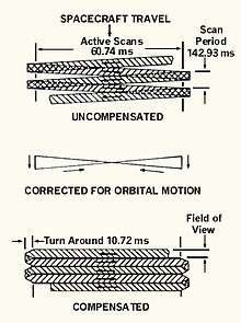
On 31 May 2003, the Scan Line Corrector (SLC) in the ETM+ instrument failed. The SLC consists of a pair of small mirrors that rotate about an axis in tandem with the motion of the main ETM+ scan mirror. The purpose of the SLC is to compensate for the forward motion (along-track) of the spacecraft so that the resulting scans are aligned parallel to each other. Without the effects of the SLC, the instrument images the Earth in a "zig-zag" fashion, resulting in some areas that are imaged twice and others that are not imaged at all. The net effect is that approximately 22% of the data in a Landsat 7 scene is missing when acquired without a functional SLC.
Following the SLC failure, an Anomaly Response Team (ART) was assembled, consisting of representatives from the USGS, NASA, and Hughes Santa Barbara Remote Sensing (the manufacturer of the ETM+ instrument). The team assembled a list of possible failure scenarios, most of which pointed at a mechanical problem with the SLC itself. Since there is no backup SLC, a mechanical failure would indicate that the problem was permanent. However, the team was unable to rule out the possibility of an electrical failure, though such a possibility was deemed remote. Nevertheless, on 3 September 2003, USGS director Charles G. Groat authorized the Landsat project to reconfigure the ETM+ instrument and various other subsystems on board Landsat 7 to use the spacecraft's redundant ("Side-B") electrical harness.
With this authorization, the USGS flight operations team at the NASA Goddard Space Flight Center uploaded a series of commands to the spacecraft, instructing it to operate using the redundant electrical harness. This operation was successful, and on 5 September 2003, the ETM+ instrument was turned on and acquired data that was sent to the Landsat ground system at EROS outside Sioux Falls, South Dakota. It was immediately apparent that the migration to the Side-B electrical harness had not fixed the problem with the SLC. Following this, the instrument was reconfigured again to use its primary electrical harness. The subsequent conclusion of the Anomaly Response Team was that the SLC problem was mechanical and permanent in nature.
Landsat 7 continues to acquire data in this mode. Data products are available with the missing data optionally filled in using other Landsat 7 data selected by the user. In 2013, Landsat 7 was joined by Landsat 8.
Satellite imagery
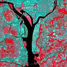
In August 1998, NASA contracted EarthSat to produce Landsat GeoCover (Geocover 2000 in NASA WorldWind) — a positionally accurate orthorectified Landsat Thematic Mapper and Multispectral Scanner imagery covering the majority of the Earth's land mass. The contract was part of the NASA Scientific Data Purchase which was administrated through NASA's John C. Stennis Space Center. GeoCover was later enhanced to EarthSat NaturalVue, a simulated natural color Landsat 7 derived circa year 2000, orthorectified, mosaicked and color balanced digital image dataset. Other commercial simulated true color 15-metre global imagery products built from the NASA Landsat 7 imagery include TerraColor from Earthstar Geographics, TruEarth (found in Google Earth and Google Maps) from TerraMetrics, BrightEarth from ComputaMaps, simulated natural color from Atlogis and a product of i-cubed used in NASA WorldWind.
Largest parts of the Earth surface displayed on web mapping services like Google Maps/Google Earth, MSN Maps or Yahoo! Maps are based on enhanced and color balanced Landsat 7 imagery.
See also
References
- "LANDSAT 7 Satellite details 1999-020A NORAD 25682". N2YO. 25 January 2015. Retrieved 25 January 2015.
- EO-1 Phase F Report

- "NASA's Restore-L Mission to Refuel Landsat 7, Demonstrate Crosscutting Technologies". 23 June 2016. Retrieved 21 December 2017.
- "Maxar and NASA Successfully Complete Design Review for Restore-L On-Orbit Servicing Spacecraft Bus". Maxar Technologies (Press release). 8 April 2019. Retrieved 9 November 2019.
External links
- NASA's Landsat 7 Website
- Landsat 7 Science Data Users Handbook
- The USGS' Landsat Website
- "Landsat 7 Media Kit". Boeing. Archived from the original on 8 May 1999.
- NASA's World Wind Project
- NASA Applied Sciences Directorate website for free viewing/download of Landsat GeoCover band 742 mosaics
- University of Maryland Global Land Cover Facility for free viewing/download of individual Landsat images, GeoCover mosaics, and other earth imagery data
- Harris GLOBE15 - Harris Corporation Geospatial website (includes 15m global data set details)
- EarthSat's NaturalVue 2000: Global natural color satellite imagery coverage (resolution 15 m), based on Landsat 7 data acquired between 1999 and 2001
- TerraColor.Net - TerraColor 15m imagery website
- TruEarth 15m imagery website
- ICEDS Webserver, a free WMS compliant webserver, serving a variety of Geographic data including Landsat images
- Atlogis Maps and Atlogis Meta-Maps: Online-Viewer for Landsat 5 and Landsat 7 Natural Color Mosaic
- CEOS MIM Database Landsat 7 Entry