Polar Operational Environmental Satellites
The Polar-orbiting Operational Environmental Satellite (POES) was a constellation of polar orbiting weather satellites funded by the National Oceanic and Atmospheric Administration (NOAA) and the European Organization for the Exploitation of Meteorological Satellites (EUMETSAT) with the intent of improving the accuracy and detail of weather analysis and forecasting.[1] The Spacecraft were provided by NASA and the European Space Agency, and NASA's Goddard Space Flight Center oversaw the manufacture, integration and test of the NASA-provided TIROS satellites.[2] The first polar-orbiting weather satellite launched as part of the POES constellation was the Television Infrared Observation Satellite (TIROS), which was launched on April 1, 1960. The final spacecraft, NOAA-19, was launched in February 2009. [3] The ESA-provided MetOp satellite operated by EUMETSAT utilize POES-heritage instruments for the purpose of data continuity. The Joint Polar Satellite System (JPSS), which was launched on November 18, 2017, is the successor to the POES Program.[4]
On-orbit satellite operations of POES is performed by NOAA's Office of Satellite and Product Operations (OSPO).[5]
Daily global coverage
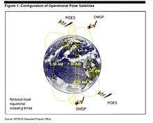
Each POES satellite completes roughly 14.1 orbits per day. Since the number of orbits per day is not an integer, the ground tracks do not repeat on a daily basis. The systems includes both morning and afternoon satellites which provide global coverage four times daily.[5]
Applications
Data from the POES support a broad range of environmental monitoring applications including weather analysis and forecasting, climate research and prediction, global sea surface temperature measurements, atmospheric soundings of temperature and humidity, ocean dynamics research, volcanic eruption monitoring, forest fire detection, global vegetation analysis, search and rescue, and many other applications.[5]
One of the key instruments of the current POES MetOp-B system is the High Resolution Infrared Radiation Sounder (HIRS/4). HIRS/4 senses within 20 channels ranging from visible bands to long wave infrared (0.69-14.96 micron wavelengths), to sense variation of temperature, humidity, and pressures within the atmosphere.[3] The data collected from HIRS/4 is collaboratively used with the Advanced Microwave Sounding Instrument (AMSU) to advance research in sea surface temperatures, cloud coverage analysis, ozone concentrations throughout the atmosphere and earth's radiance.[2][3]
SARSAT
POES has been used by the Search and Rescue community since 1982. COSPAS-SARSAT is the international humanitarian Search and Rescue Satellite-Aided Tracking System that is responsible for alerting and locating information to search and rescue authorities. COSPAS-SARSAT satellites detect 406 MHz distress signals at all times from nearly any place on the globe. Each 406 MHz beacon has a unique fifteen digit identification (ID) code embedded within its signal which allows rescuers to have an identification of the party in distress before they head out on the rescue. There is no charge for this service provided in conjunction with NOAA and SARSAT.[6]
Mission
- TIROS-1 - Launched 1 April 1960 from Cape Canaveral, FL[7]
- TIROS-2 - Launched on November 23, 1960 from Cape Canaveral, FL[8]
- TIROS-N - Launched November 1978. Ended February 1981.
- NOAA-6 - Launched July 1979. Ended November 1986.
- NOAA-7 - Launched August 1981. Ended January 1985.
- NOAA-8 - Launched May 1983. Ended October 1985.
- NOAA-10 - Launched October 1986. Ended August 1991.
- NOAA-12 - Launched June 1991. Ended March 2001.
- NOAA-14 - Launched February 1994. Ended December 2004.
- NOAA-15 - Launched July 1998. Still in Use.
- NOAA-16 - Launched January 2001. Ended June 2014.
- NOAA-17 - Launched 24 June 2002 from Vandenberg Air Force Base, USA. Ended April 2014
- NOAA-18 - Launched 20 May 2005 from Vandenberg Air Force Base, USE. Still in use.
- MetOp-A - Launched 19 October 2006 from Baikonur Cosmodrome, Kazakhstan. Still in use.
- NOAA-19 - Launched on February 6, 2009, the fifth and last in the current series of polar-orbiting satellites[8] Still in use.
The MetOp missions are not part of POES, but use POES heritage instruments.
See also
References
- "EUMETSAT Polar System - Programme Background". EUMETSAT. Archived from the original on 2008-11-23.
- "POES Project". NASA. Archived from the original on 2008-09-26.
- ". . . P O E S . . ". poes.gsfc.nasa.gov. Retrieved 2017-03-19.
- "NOAA/NASA Joint Polar Satellite System (JPSS) Management Control Plan (MCP) 2013" (PDF). January 2013.
- "Polar Orbiting Satellites". NOAA. Archived from the original on 2007-12-20.
- "COSPAS SARSAT - Search and Rescue Satellite Aided Tracking System" (PDF). NOAA. Archived (PDF) from the original on March 19, 2017. Retrieved March 21, 2017.
- "A History of POES". poes.gsfc.nasa.gov. Retrieved 2017-03-19.
- "POES Timeline". poes.gsfc.nasa.gov. Retrieved 2017-03-19.
- "MetOp-B Launches with NASA Goddard-Developed Instruments."NASA. Retrieved: 21 June 2012.