Morris County, Texas
Morris County is a county located near the eastern border of the U.S. state of Texas. As of the 2010 census, its population was 12,934.[1] Its county seat is Daingerfield.[2] Morris County is probably named for William Wright Morris, an early judge and planter from Henderson, also in northeast Texas. As of 2016, Morris County is no longer one of 25 prohibition, or entirely dry, counties in the state of Texas. Morris County is now "partially wet." [3]
Morris County | |
|---|---|
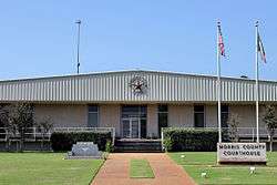 The Morris County Courthouse in Daingerfield | |
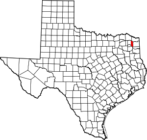 Location within the U.S. state of Texas | |
 Texas's location within the U.S. | |
| Coordinates: 33°07′N 94°44′W | |
| Country | |
| State | |
| Founded | 1875 |
| Seat | Daingerfield |
| Largest city | Daingerfield |
| Area | |
| • Total | 259 sq mi (670 km2) |
| • Land | 252 sq mi (650 km2) |
| • Water | 6.7 sq mi (17 km2) 2.6%% |
| Population (2010) | |
| • Total | 12,934 |
| • Density | 51/sq mi (20/km2) |
| Time zone | UTC−6 (Central) |
| • Summer (DST) | UTC−5 (CDT) |
| Congressional district | 4th |
| Website | www |
History
In the nineteenth century, this area was settled primarily by European-American planters and farmers, many of whom brought enslaved African Americans with them or purchased others to work as laborers on the cotton plantations they developed. Cotton was most important, but farmers also cultivated other commodity crops before the American Civil War. Eastern Texas was the region of the state with the highest number and proportion of slaves.
The area has continued to be mostly rural and agricultural. In the 21st century, African Americans comprise a significant minority in the county.
Geography
According to the U.S. Census Bureau, the county has a total area of 259 square miles (670 km2), of which 252 square miles (650 km2) is land and 6.7 square miles (17 km2) (2.6%) is water.[4] It is the fifth-smallest county in Texas by land area and fourth-smallest by total area.
Adjacent counties
- Bowie County (north)
- Cass County (east)
- Marion County (southeast)
- Upshur County (south)
- Camp County (southwest)
- Titus County (west)
- Red River County (northwest)
Demographics
| Historical population | |||
|---|---|---|---|
| Census | Pop. | %± | |
| 1880 | 5,032 | — | |
| 1890 | 6,580 | 30.8% | |
| 1900 | 8,220 | 24.9% | |
| 1910 | 10,439 | 27.0% | |
| 1920 | 10,289 | −1.4% | |
| 1930 | 10,028 | −2.5% | |
| 1940 | 9,810 | −2.2% | |
| 1950 | 9,433 | −3.8% | |
| 1960 | 12,576 | 33.3% | |
| 1970 | 12,310 | −2.1% | |
| 1980 | 14,629 | 18.8% | |
| 1990 | 13,200 | −9.8% | |
| 2000 | 13,048 | −1.2% | |
| 2010 | 12,934 | −0.9% | |
| Est. 2019 | 12,388 | [5] | −4.2% |
| U.S. Decennial Census[6] 1850–2010[7] 2010–2014[1] | |||
As of the census[8] of 2000, there were 13,048 people, 5,215 households, and 3,749 families residing in the county. The population density was 51 people per square mile (20/km²). There were 6,017 housing units at an average density of 24 per square mile (9/km²). The racial makeup of the county was 71.71% White, 24.13% Black or African American, 0.53% Native American, 0.18% Asian, 0.06% Pacific Islander, 2.28% from other races, and 1.12% from two or more races. 3.66% of the population were Hispanic or Latino of any race.
There were 5,215 households out of which 29.50% had children under the age of 18 living with them, 53.90% were married couples living together, 14.10% had a female householder with no husband present, and 28.10% were non-families. 25.80% of all households were made up of individuals and 13.20% had someone living alone who was 65 years of age or older. The average household size was 2.47 and the average family size was 2.95.
In the county, the population was spread out with 25.20% under the age of 18, 7.80% from 18 to 24, 24.30% from 25 to 44, 24.50% from 45 to 64, and 18.30% who were 65 years of age or older. The median age was 40 years. For every 100 females there were 92.70 males. For every 100 females age 18 and over, there were 87.40 males.
The median income for a household in the county was $29,011, and the median income for a family was $35,326. Males had a median income of $30,917 versus $20,270 for females. The per capita income for the county was $15,612. About 14.90% of families and 18.30% of the population were below the poverty line, including 25.40% of those under age 18 and 12.90% of those age 65 or over.
Education
The following school districts serve Morris County:
- Daingerfield-Lone Star ISD (small portion in Titus County)
- Hughes Springs ISD (mostly in Cass County)
- Pewitt CISD (small portions in Titus and Cass counties)
Morris County is also served by the Northeast Texas Community College, whose main campus is in southeastern Titus County, but it has a small satellite campus in Naples.
Communities
Cities
- Daingerfield (county seat)
- Hughes Springs (mostly in Cass County)
- Lone Star
- Omaha
Town
Politics
| Year | Republican | Democratic | Third parties |
|---|---|---|---|
| 2016 | 69.3% 3,446 | 28.7% 1,425 | 2.1% 102 |
| 2012 | 62.9% 3,232 | 36.2% 1,858 | 1.0% 49 |
| 2008 | 60.2% 3,158 | 39.2% 2,055 | 0.7% 35 |
| 2004 | 53.4% 2,818 | 46.2% 2,437 | 0.4% 23 |
| 2000 | 48.7% 2,381 | 50.2% 2,455 | 1.1% 53 |
| 1996 | 30.0% 1,449 | 61.6% 2,973 | 8.4% 406 |
| 1992 | 25.1% 1,400 | 54.4% 3,028 | 20.5% 1,141 |
| 1988 | 37.4% 2,104 | 62.6% 3,522 | 0.1% 4 |
| 1984 | 48.5% 2,778 | 51.1% 2,925 | 0.4% 24 |
| 1980 | 40.4% 2,133 | 58.8% 3,105 | 0.8% 42 |
| 1976 | 37.4% 1,843 | 62.3% 3,071 | 0.3% 17 |
| 1972 | 69.5% 2,699 | 29.9% 1,162 | 0.6% 24 |
| 1968 | 26.0% 1,064 | 41.6% 1,701 | 32.4% 1,323 |
| 1964 | 33.9% 1,218 | 65.8% 2,366 | 0.3% 10 |
| 1960 | 44.3% 1,569 | 55.1% 1,952 | 0.7% 23 |
| 1956 | 47.6% 1,463 | 51.8% 1,592 | 0.7% 20 |
| 1952 | 34.1% 890 | 65.9% 1,722 | 0.0% 1 |
| 1948 | 9.2% 143 | 74.8% 1,164 | 16.0% 249 |
| 1944 | 8.3% 122 | 86.0% 1,269 | 5.8% 85 |
| 1940 | 4.5% 82 | 95.5% 1,752 | |
| 1936 | 4.1% 52 | 95.9% 1,220 | |
| 1932 | 2.9% 38 | 97.1% 1,253 | |
| 1928 | 26.9% 287 | 73.1% 780 | |
| 1920 | 18.1% 164 | 73.7% 669 | 8.3% 75 |
| 1916 | 15.3% 163 | 64.6% 689 | 20.2% 215 |
| 1912 | 25.7% 89 | 55.2% 191 | 19.1% 66 |
See also
- Dry counties
- Ernest Wallace, historian of the South Plains
- National Register of Historic Places listings in Morris County, Texas
- Recorded Texas Historic Landmarks in Morris County
References
- "State & County QuickFacts". United States Census Bureau. Archived from the original on September 21, 2011. Retrieved December 22, 2013.
- "Find a County". National Association of Counties. Retrieved 2011-06-07.
- "TABC Home Page". www.tabc.state.tx.us. Retrieved 2018-07-28.
- "2010 Census Gazetteer Files". United States Census Bureau. August 22, 2012. Retrieved May 4, 2015.
- "Population and Housing Unit Estimates". United States Census Bureau. May 24, 2020. Retrieved May 27, 2020.
- "U.S. Decennial Census". United States Census Bureau. Retrieved May 4, 2015.
- "Texas Almanac: Population History of Counties from 1850–2010" (PDF). Texas Almanac. Retrieved May 4, 2015.
- "U.S. Census website". United States Census Bureau. Retrieved 2011-05-14.
- Leip, David. "Dave Leip's Atlas of U.S. Presidential Elections". uselectionatlas.org. Retrieved 2018-07-28.
External links
- Morris County website
- Morris County from the Handbook of Texas Online
Places adjacent to Morris County, Texas | ||||||||||
|---|---|---|---|---|---|---|---|---|---|---|
| ||||||||||
Municipalities and communities of Morris County, Texas, United States | ||
|---|---|---|
| Cities | Morris County map | |
| Town | ||
| Unincorporated communities | ||
| Footnotes | ‡This populated place also has portions in an adjacent county or counties | |

| Authority control |
|
|---|