Irion County, Texas
Irion County (/ˈaɪriən/ EYE-ree-ən) is a county located on the Edwards Plateau in the U.S. state of Texas. As of the 2010 census, its population was 1,599.[1] Its county seat is Mertzon.[2] The county is named for Robert Anderson Irion, a secretary of state of the Republic of Texas.
Irion County | |
|---|---|
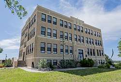 The Irion County Courthouse in Mertzon | |
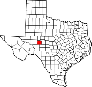 Location within the U.S. state of Texas | |
 Texas's location within the U.S. | |
| Coordinates: 31°18′N 100°59′W | |
| Country | |
| State | |
| Founded | 1889 |
| Named for | Robert Anderson Irion |
| Seat | Mertzon |
| Largest city | Mertzon |
| Area | |
| • Total | 1,052 sq mi (2,720 km2) |
| • Land | 1,052 sq mi (2,720 km2) |
| • Water | 0.07 sq mi (0.2 km2) 0.01%% |
| Population (2010) | |
| • Total | 1,599 |
| • Density | 1.5/sq mi (0.6/km2) |
| Time zone | UTC−6 (Central) |
| • Summer (DST) | UTC−5 (CDT) |
| Congressional district | 11th |
| Website | www |
Irion County is included in the San Angelo, Texas, Metropolitan Statistical Area.
History
Beginning in 1858, until 1861, Butterfield Overland Mail crosses the region.[3]
In 1876 John Arden brought the first flock of sheep from California and Billy Childress established the longhorn 7D Ranch.[4]
The Texas legislature forms Irion County from Tom Green County in 1889. Sherwood becomes the county seat.[5]
Oil was discovered in Irion County in 1928.[6]
In 1936 Mertzon becomes county seat.[7]
Currently, the Old Irion County Courthouse in Sherwood is the only property in the county which is listed on the National Register of Historic Places.
Geography
According to the U.S. Census Bureau, the county has a total area of 1,052 square miles (2,720 km2), of which 1,052 square miles (2,720 km2) is land and 0.07 square miles (0.18 km2) (0.01%) is water.[8] The Spraberry Trend, the third-largest oil field in the United States by remaining reserves, underlies much of the county.[9]
Major highways


Adjacent counties
- Tom Green County (north and east)
- Schleicher County (southeast)
- Crockett County (southwest)
- Reagan County (west)
Demographics
| Historical population | |||
|---|---|---|---|
| Census | Pop. | %± | |
| 1890 | 870 | — | |
| 1900 | 848 | −2.5% | |
| 1910 | 1,283 | 51.3% | |
| 1920 | 1,610 | 25.5% | |
| 1930 | 2,049 | 27.3% | |
| 1940 | 1,963 | −4.2% | |
| 1950 | 1,590 | −19.0% | |
| 1960 | 1,183 | −25.6% | |
| 1970 | 1,070 | −9.6% | |
| 1980 | 1,386 | 29.5% | |
| 1990 | 1,629 | 17.5% | |
| 2000 | 1,771 | 8.7% | |
| 2010 | 1,599 | −9.7% | |
| Est. 2019 | 1,536 | [10] | −3.9% |
| U.S. Decennial Census[11] 1850–2010[12] 2010–2014[1] | |||
As of the census[13] of 2000, there were 1,771 people, 694 households, and 523 families residing in the county. The population density was 2 people per square mile (1/km²). There were 914 housing units at an average density of 1 per square mile (0/km²). The racial makeup of the county was 90.68% White, 0.40% Black or African American, 0.79% Native American, 6.55% from other races, and 1.58% from two or more races. 24.62% of the population were Hispanic or Latino of any race.
There were 694 households out of which 32.40% had children under the age of 18 living with them, 64.80% were married couples living together, 6.60% had a female householder with no husband present, and 24.50% were non-families. 21.80% of all households were made up of individuals and 11.20% had someone living alone who was 65 years of age or older. The average household size was 2.55 and the average family size was 2.97.
In the county, the population was spread out with 26.70% under the age of 18, 4.70% from 18 to 24, 26.90% from 25 to 44, 26.10% from 45 to 64, and 15.60% who were 65 years of age or older. The median age was 40 years. For every 100 females there were 100.30 males. For every 100 females age 18 and over, there were 99.40 males.
The median income for a household in the county was $37,500, and the median income for a family was $45,458. Males had a median income of $35,642 versus $20,395 for females. The per capita income for the county was $20,515. About 8.30% of families and 8.40% of the population were below the poverty line, including 7.20% of those under age 18 and 7.90% of those age 65 or over.
Oil & Gas Activity Summary
Irion County, TX is one of the highest BOE counties in Texas. The table below contains oil and gas data from 1993 through Sept 2019 covering 4,910 wells that have been producing in that period of time.
| Category | Last Year Value | Current Year Value | YoY Trend | YoY % Change |
|---|---|---|---|---|
| Total Wells | 3,505 | 4,910 | Up | 40.09% |
| Total Producing Wells | 2,896 | 2,847 | Down | -1.69% |
| Percentage of Wells Producing | 83% | 58% | Down | 43% |
| Past Year Active Producers | 77 | 68 | Down | -12% |
| Past Year Total Permits | 162 | 288 | Up | 78% |
| Average Well Depth | 6,549 | 6,549 | Flat | 0% |
| Average BOE per Well | 340 | 350 | Up | 3% |
Notable natives
- Laura Bullion, female Old West outlaw, born in Knickerbocker.[15]
Politics
| Year | Republican | Democratic | Third parties |
|---|---|---|---|
| 2016 | 86.2% 660 | 11.8% 90 | 2.1% 16 |
| 2012 | 84.8% 668 | 14.2% 112 | 1.0% 8 |
| 2008 | 78.8% 644 | 20.1% 164 | 1.1% 9 |
| 2004 | 82.6% 684 | 17.0% 141 | 0.4% 3 |
| 2000 | 78.7% 624 | 20.4% 162 | 0.9% 7 |
| 1996 | 55.9% 386 | 30.9% 213 | 13.2% 91 |
| 1992 | 34.1% 283 | 30.8% 256 | 35.1% 292 |
| 1988 | 62.2% 539 | 37.6% 326 | 0.2% 2 |
| 1984 | 75.3% 619 | 24.2% 199 | 0.5% 4 |
| 1980 | 63.7% 427 | 35.7% 239 | 0.6% 4 |
| 1976 | 50.0% 302 | 49.2% 297 | 0.8% 5 |
| 1972 | 76.1% 363 | 23.3% 111 | 0.6% 3 |
| 1968 | 43.1% 211 | 38.2% 187 | 18.8% 92 |
| 1964 | 36.2% 199 | 63.8% 351 | |
| 1960 | 48.9% 238 | 50.5% 246 | 0.6% 3 |
| 1956 | 58.3% 252 | 41.2% 178 | 0.5% 2 |
| 1952 | 48.7% 268 | 51.3% 282 | |
| 1948 | 14.3% 63 | 83.2% 366 | 2.5% 11 |
| 1944 | 11.9% 54 | 80.1% 363 | 8.0% 36 |
| 1940 | 11.6% 74 | 87.9% 560 | 0.5% 3 |
| 1936 | 9.3% 49 | 89.8% 476 | 0.9% 5 |
| 1932 | 10.3% 47 | 87.3% 398 | 2.4% 11 |
| 1928 | 68.5% 259 | 31.5% 119 | |
| 1924 | 25.4% 73 | 71.2% 205 | 3.5% 10 |
| 1920 | 20.1% 45 | 66.1% 148 | 13.8% 31 |
| 1916 | 3.0% 5 | 90.4% 150 | 6.6% 11 |
| 1912 | 0.0% 0 | 89.8% 132 | 10.2% 15 |
See also
References
- "State & County QuickFacts". United States Census Bureau. Archived from the original on October 18, 2011. Retrieved December 17, 2013.
- "Find a County". National Association of Counties. Archived from the original on 2011-05-31. Retrieved 2011-06-07.
- Hunt, William R; Leffler, John. "Irion County". Handbook of Texas Online. Texas State Historical Association. Retrieved 29 November 2010.
- Lanning, James and Judy (1995). Texas Cowboys: Memories of the Early Days. TAMU Press. p. 57. ISBN 978-0-89096-658-7.
- "Sherwood, Texas". Texas Escapes. Texas Escapes - Blueprints For Travel, LLC. Retrieved 29 November 2010.
- Warner, C A; Thompson, Ernest O (2007). Texas Oil & Gas Since 1543. Copano Bay Press. p. 299. ISBN 978-0-9767799-5-7.
- "Mertzon, Texas". Texas Escapes. Texas Escapes - Blueprints For Travel, LLC. Retrieved 29 November 2010.
- "2010 Census Gazetteer Files". United States Census Bureau. August 22, 2012. Retrieved April 30, 2015.
- Top 100 Oil and Gas Fields Archived 2009-05-15 at the Wayback Machine
- "Population and Housing Unit Estimates". United States Census Bureau. May 24, 2020. Retrieved May 27, 2020.
- "U.S. Decennial Census". United States Census Bureau. Retrieved April 30, 2015.
- "Texas Almanac: Population History of Counties from 1850–2010" (PDF). Texas Almanac. Retrieved April 30, 2015.
- "U.S. Census website". United States Census Bureau. Retrieved 2011-05-14.
- "Irion County, TX Mineral & Royalty Information". www.mineralanswers.com. Retrieved 2020-01-27.
- Magness, Perre, Cohort of Butch, Sundance 'retired' here, Commercial Appeal, Memphis, Jan. 12, 1995, page EC2
- Leip, David. "Dave Leip's Atlas of U.S. Presidential Elections". uselectionatlas.org. Retrieved 2018-07-25.
External links
- Irion County government website
- Irion County from the Handbook of Texas Online
- Inventory of county records, Irion County courthouse, Mertzon, Texas, hosted by the Portal to Texas History
- Irion County Profile from the Texas Association of Counties
Places adjacent to Irion County, Texas | ||||||||||
|---|---|---|---|---|---|---|---|---|---|---|
| ||||||||||
Municipalities and communities of Irion County, Texas, United States | ||
|---|---|---|
| City | Irion County map | |
| Unincorporated communities | ||

| Authority control |
|
|---|