Texas State Highway 77
State Highway 77, or SH 77, is a numbered state highway in Texas, occupying the counties of Morris and Cass. SH 77 is 46.815 miles (75.341 km) long, and connects U.S. Highway 259 (US 259) to the Louisiana state line.
| ||||
|---|---|---|---|---|
 | ||||
| Route information | ||||
| Maintained by TxDOT | ||||
| Length | 46.815 mi[1] (75.341 km) | |||
| Existed | 1923–present | |||
| Major junctions | ||||
| West end | ||||
| East end | ||||
| Location | ||||
| Counties | Morris and Cass | |||
| Highway system | ||||
| ||||

Route description
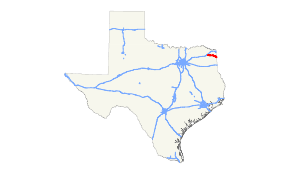
SH 77 begins 4 miles (6.4 km) north of Omaha on US 259, and travels eastward to Naples, meeting US 67 and SH 338. In Douglassville, SH 77 intersects SH 8. After cutting across the south side of Atlanta, where it meets US 59 (Future Interstate 369), SH 77 cuts to the southeast, and crosses into the very northwest corner of Louisiana near Three Corners (where Arkansas, Louisiana and Texas meet), becoming Louisiana Highway 1.
History
SH 77 was originally proposed on August 21, 1923, as a route from Douglasville to Naples, replacing SH 1B.[2] On June 24, 1931, SH 77 was extended southeast to Louisiana, replacing a portion of SH 47.[3] On March 11, 1935, SH 77 Spur was designated to Marietta. This would be cancelled on completion, but would be restored on April 19, 1937, as SH 245. On September 26, 1939, SH 77 was extended west to Commerce, replacing SH 260 but this plan was cancelled on January 14, 1941. On February 28, 1966, SH 77 was extended west over FM 2880 from US 259 to US 67.[4]
Junction list
| County | Location | mi[5] | km | Destinations | Notes |
|---|---|---|---|---|---|
| Morris | | 0.0 | 0.0 | ||
| Naples | 4.5 | 7.2 | Interchange | ||
| 5.0 | 8.0 | ||||
| Cass | | 6.5 | 10.5 | ||
| | 9.6 | 15.4 | |||
| | 12.7 | 20.4 | |||
| | 16.0 | 25.7 | |||
| | 18.2 | 29.3 | |||
| Douglassville | 23.7 | 38.1 | |||
| | 27.7 | 44.6 | |||
| | 30.5 | 49.1 | |||
| | 32.2 | 51.8 | |||
| Atlanta | 35.0 | 56.3 | |||
| 35.3 | 56.8 | West end of US 59 overlap | |||
| 35.7 | 57.5 | East end of US 59 overlap | |||
| 36.3 | 58.4 | ||||
| 37.0 | 59.5 | ||||
| 37.6 | 60.5 | ||||
| | 41.0 | 66.0 | |||
| | 44.7 | 71.9 | |||
| | 47.1 | 75.8 | |||
1.000 mi = 1.609 km; 1.000 km = 0.621 mi
| |||||
References
- Transportation Planning and Programming Division (n.d.). "State Highway No. 77". Highway Designation Files. Texas Department of Transportation. Retrieved July 21, 2018.
- "August 21, 1923 Minute Order" (PDF).
- "June 22, 1931 Minute Order" (PDF).
- Transportation Planning and Programming Division (n.d.). "Farm to Market Road No. 2880". Highway Designation Files. Texas Department of Transportation. Retrieved June 25, 2018.
- Google (June 25, 2018). "Route of SH 77" (Map). Google Maps. Google. Retrieved June 25, 2018.