Cooke County, Texas
Cooke County is a county in the U.S. state of Texas. At the 2010 census, its population was 38,437.[1] The county seat is Gainesville.[2] The county was founded in 1848 and organized the next year. It is named for William Gordon Cooke, a soldier during the Texas Revolution. It is a part of the Texoma region.
Cooke County | |
|---|---|
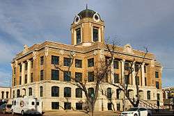 The Cooke County Courthouse in Gainesville | |
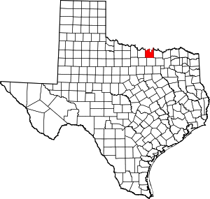 Location within the U.S. state of Texas | |
 Texas's location within the U.S. | |
| Coordinates: 33°38′00″N 97°13′00″W | |
| Country | |
| State | |
| Founded | 1849 |
| Seat | Gainesville |
| Largest city | Gainesville |
| Area | |
| • Total | 898 sq mi (2,330 km2) |
| • Land | 875 sq mi (2,270 km2) |
| • Water | 24 sq mi (60 km2) 2.6%% |
| Population (2016) | |
| • Total | 39,141 |
| • Density | 44/sq mi (17/km2) |
| Time zone | UTC−6 (Central) |
| • Summer (DST) | UTC−5 (CDT) |
| Congressional district | 13th |
| Website | www |
Cooke County comprises the Gainesville, TX Micropolitan Statistical Area, which is also included in the Dallas–Fort Worth, TX-OK Combined Statistical Area.
Republican Drew Springer, Jr., a businessman from Muenster, has represented Cooke County in the Texas House of Representatives since January 2013.[3]
Geography
According to the U.S. Census Bureau, the county has an area of 898 square miles (2,330 km2), of which 875 square miles (2,270 km2) are land and 24 square miles (62 km2) (2.6%) are covered by water.[4]
Major highways
.svg.png)


Adjacent counties
- Love County, Oklahoma (north)
- Grayson County (east)
- Denton County (south)
- Wise County (southwest)
- Montague County (west)
Demographics
| Historical population | |||
|---|---|---|---|
| Census | Pop. | %± | |
| 1850 | 220 | — | |
| 1860 | 3,760 | 1,609.1% | |
| 1870 | 5,315 | 41.4% | |
| 1880 | 20,391 | 283.7% | |
| 1890 | 24,696 | 21.1% | |
| 1900 | 27,494 | 11.3% | |
| 1910 | 26,603 | −3.2% | |
| 1920 | 25,667 | −3.5% | |
| 1930 | 24,136 | −6.0% | |
| 1940 | 24,909 | 3.2% | |
| 1950 | 22,146 | −11.1% | |
| 1960 | 22,560 | 1.9% | |
| 1970 | 23,471 | 4.0% | |
| 1980 | 27,656 | 17.8% | |
| 1990 | 30,777 | 11.3% | |
| 2000 | 36,363 | 18.1% | |
| 2010 | 38,437 | 5.7% | |
| Est. 2019 | 41,257 | [5] | 7.3% |
| U.S. Decennial Census[6] 1850–2010[7] 2010–2014[1] | |||
According to statistical data from 2016, Cooke County has a population of 39,141 people (41% urban, 59% rural), nearly 14,000 households, and over 10,000 families. The population density was 42 per square mile (16/km²). The 15,061 housing units averaged 17 per square mile (7/km²). The racial makeup of the county was 88.84% White, 3.06% Black or African American, 1.00% Native American, 0.34% Asian, 0.01% Pacific Islander, 5.16% from other races, and 1.61% from two or more races. About 10% of the population was Hispanic or Latino of any race.
Of the more than 14,000 households in Cooke County, 33.90% had children under the age of 18 living in the home, 59.60% were married couples living together, 9.90% had a female householder with no husband present, and 26.70% were not families; 23.30% of all households were made up of individuals, and 11.10% had someone living alone who was 65 years of age or older. The average household size was 2.60 and the average family size was 3.07.
The population was distributed as 27.30% under the age of 18, 8.70% from 18 to 24, 26.10% from 25 to 44, 23.00% from 45 to 64, and 14.90% who were 65 years of age or older. The median age was 37 years. For every 100 females, there were 97.40 males. For every 100 females age 18 and over, there were 92.80 males.
While 2015 estimates place the median household income for Cooke County at $53,552, past estimates showed the median household income to be $37,649, with the median family income being $44,869. Males had a median income of $32,429 and females $22,065. The per capita income was $17,889. About 10.90% of families and 14.10% of the population were below the poverty line, including 19.80% of those under age 18 and 10.70% of those age 65 or over. Median house values in 2015 were $118,254.
Government and infrastructure
The Texas Juvenile Justice Department operates the Gainesville State School in an unincorporated area in Cooke County, east of Gainesville.[8]
Politics
Cooke County is heavily Republican. The last Democrat to win Cooke County was Lyndon B. Johnson in 1964.
| Year | Republican | Democratic | Third parties |
|---|---|---|---|
| 2016 | 82.6% 13,181 | 14.7% 2,352 | 2.6% 422 |
| 2012 | 83.3% 11,951 | 15.7% 2,246 | 1.1% 154 |
| 2008 | 78.9% 11,871 | 20.3% 3,051 | 0.9% 132 |
| 2004 | 78.8% 11,908 | 20.8% 3,142 | 0.4% 57 |
| 2000 | 75.2% 10,128 | 23.4% 3,153 | 1.4% 188 |
| 1996 | 59.5% 7,320 | 30.8% 3,782 | 9.7% 1,195 |
| 1992 | 40.5% 5,299 | 23.7% 3,105 | 35.8% 4,680 |
| 1988 | 62.8% 7,196 | 36.8% 4,217 | 0.3% 39 |
| 1984 | 71.4% 8,260 | 28.4% 3,278 | 0.2% 26 |
| 1980 | 62.6% 6,760 | 35.6% 3,842 | 1.9% 200 |
| 1976 | 51.5% 4,804 | 48.1% 4,483 | 0.5% 42 |
| 1972 | 78.3% 6,317 | 21.1% 1,702 | 0.6% 51 |
| 1968 | 48.0% 3,799 | 34.2% 2,711 | 17.8% 1,412 |
| 1964 | 43.2% 3,117 | 56.6% 4,083 | 0.2% 11 |
| 1960 | 55.5% 3,983 | 44.2% 3,168 | 0.4% 25 |
| 1956 | 64.3% 4,164 | 35.1% 2,272 | 0.6% 37 |
| 1952 | 62.2% 4,385 | 37.7% 2,657 | 0.1% 8 |
| 1948 | 23.8% 1,194 | 64.5% 3,241 | 11.8% 591 |
| 1944 | 18.6% 919 | 66.2% 3,270 | 15.2% 749 |
| 1940 | 23.2% 1,358 | 76.6% 4,483 | 0.2% 12 |
| 1936 | 15.6% 686 | 83.9% 3,686 | 0.5% 20 |
| 1932 | 11.0% 470 | 88.5% 3,775 | 0.5% 20 |
| 1928 | 54.0% 2,262 | 45.9% 1,924 | 0.1% 4 |
| 1924 | 12.9% 525 | 77.6% 3,170 | 9.6% 391 |
| 1920 | 29.6% 1,003 | 64.1% 2,170 | 6.4% 215 |
| 1916 | 12.9% 353 | 83.1% 2,273 | 4.0% 109 |
| 1912 | 9.6% 206 | 83.3% 1,780 | 7.1% 151 |
Communities
Towns
Census-designated place
Unincorporated communities
- Bulcher
- Burns City
- Dexter
- Era
- Hood
- Leo
- Lois
- Marysville
- Moss Lake
- Mountain Springs
- Myra
- Road Runner
- Prairie Point
- Rosston
- Sivells Bend
- Walnut Bend
- Woodbine
See also
References
- "State & County QuickFacts". United States Census Bureau. Retrieved December 9, 2013.
- "Find a County". National Association of Counties. Archived from the original on May 31, 2011. Retrieved June 7, 2011.
- "State Rep. Springer announces district tour July 30". Lubbock Avalanche-Journal, July 16, 2013. Retrieved July 18, 2013.
- "2010 Census Gazetteer Files". United States Census Bureau. August 22, 2012. Retrieved April 21, 2015.
- "Population and Housing Unit Estimates". United States Census Bureau. May 24, 2020. Retrieved May 27, 2020.
- "U.S. Decennial Census". United States Census Bureau. Archived from the original on April 26, 2015. Retrieved April 21, 2015.
- "Texas Almanac: Population History of Counties from 1850–2010" (PDF). Texas Almanac. Retrieved April 21, 2015.
- "Gainesville State School Archived 2011-02-20 at the Wayback Machine." Texas Youth Commission. Retrieved August 8, 2010.
- Leip, David. "Dave Leip's Atlas of U.S. Presidential Elections". uselectionatlas.org. Retrieved 2018-07-20.
External links
- Cooke County government's website
- Cooke County from the Handbook of Texas Online
Places adjacent to Cooke County, Texas | ||||||||||
|---|---|---|---|---|---|---|---|---|---|---|
| ||||||||||
Municipalities and communities of Cooke County, Texas, United States | ||
|---|---|---|
| Cities | Cooke County map | |
| Town | ||
| CDP | ||
| Other unincorporated communities | ||

| Authority control |
|
|---|