Smith County, Texas
Smith County is a county in the U.S. state of Texas. As of the 2010 census, its population was 209,714.[1] Its county seat is Tyler.[2] Smith County is named for James Smith, a general during the Texas Revolution.
Smith County | |
|---|---|
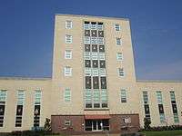 Smith County Courthouse in Tyler | |
 Seal | |
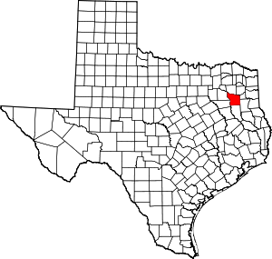 Location within the U.S. state of Texas | |
 Texas's location within the U.S. | |
| Coordinates: 32°23′N 95°16′W | |
| Country | |
| State | |
| Founded | July 1846 |
| Seat | Tyler |
| Largest city | Tyler |
| Area | |
| • Total | 950 sq mi (2,500 km2) |
| • Land | 921 sq mi (2,390 km2) |
| • Water | 28 sq mi (70 km2) 3.0%% |
| Population (2010) | |
| • Total | 209,714 |
| • Estimate (2019) | 232,751 |
| • Density | 228/sq mi (88/km2) |
| Time zone | UTC−6 (Central) |
| • Summer (DST) | UTC−5 (CDT) |
| Congressional district | 1st |
| Website | www |
Smith County is part of the Tyler metropolitan statistical area and the Tyler–Jacksonville combined statistical area.
History

For thousands of years, indigenous peoples occupied this area of present-day Texas. The first known inhabitants of the area now known as Smith County were the Caddo Indians, who were recorded here until 1819. That year, a band of Cherokees, led by The Bowl (also known as Chief Bowels), migrated from Georgia and settled in what are now Smith and Rusk Counties.[3] The Treaty of Bowles Village on February 23, 1836, between the Republic of Texas and the Cherokee and 12 affiliated tribes, gave all of Smith and Cherokees Counties, as well as parts of western Rusk County, southern Gregg (formed from Rusk County in 1873) along with southeastern Van Zandt Counties to the tribes.[4] The Native Americans remained on these lands until the Cherokee War in the summer of 1839, as part of conflicts with Native Americans in Texas. The Cherokees were driven out of Smith County, as others of their kin were forced from the Southeast United States during Indian Removal.
After 1845, some Cherokees returned when Benjamin Franklin Thompson, a white man married to a Cherokee, purchased 10,000 aces of land in Rusk County. The Mount Tabor Indian Community developed here,[5] some six miles south of present-day Kilgore. The community later grew and incorporated areas near Overton, Arp, and Troup, Texas.
In July 1846, Smith County separated from the Nacogdoches District and was named for James Smith, a general of the Texas Revolution. At this time, Tyler was designated as the county seat.[6]
Camp Ford was the largest Confederate prisoner-of-war camp west of the Mississippi River during the American Civil War. Here, Sheriff Jim Reed of Collin County and Judge McReynolds, former chief justice of the district, were seized and lynched by "Regulators". The original site of the camp stockade is now a public historic park, owned by Smith County, and managed by the Smith County Historical Society. The park contains a kiosk, a paved trail, interpretive signage, a cabin reconstruction, and a picnic area. It is located on Highway 271, 0.8 miles north of Loop 323.
20th century to present
The Smith County Historical Society, a 501(c)(3) nonprofit organization, was founded in 1959 by individuals and business firms dedicated to discovering, collecting, and preserving data, records, and other items relating to the history of Smith County. More information can be found at the Smith County Historical Society Website.[7]
Geography
According to the U.S. Census Bureau, the county has a total area of 950 square miles (2,500 km2), of which 921 square miles (2,390 km2) are land and 28 square miles (73 km2) (3.0%) are covered by water.[8]
The county infrastructure includes some 1,180 miles (1,900 km) of two-lane county road.
Major highways
.svg.png)


Adjacent counties
- Wood County (north)
- Upshur County (northeast)
- Gregg County (east)
- Rusk County (southeast)
- Cherokee County (south)
- Henderson County (southwest)
- Van Zandt County (northwest)
Demographics
| Historical population | |||
|---|---|---|---|
| Census | Pop. | %± | |
| 1850 | 4,292 | — | |
| 1860 | 13,392 | 212.0% | |
| 1870 | 16,532 | 23.4% | |
| 1880 | 21,863 | 32.2% | |
| 1890 | 28,324 | 29.6% | |
| 1900 | 37,370 | 31.9% | |
| 1910 | 41,746 | 11.7% | |
| 1920 | 46,769 | 12.0% | |
| 1930 | 53,123 | 13.6% | |
| 1940 | 69,090 | 30.1% | |
| 1950 | 74,701 | 8.1% | |
| 1960 | 86,350 | 15.6% | |
| 1970 | 97,096 | 12.4% | |
| 1980 | 128,366 | 32.2% | |
| 1990 | 151,309 | 17.9% | |
| 2000 | 174,706 | 15.5% | |
| 2010 | 209,714 | 20.0% | |
| Est. 2019 | 232,751 | [9] | 11.0% |
| U.S. Decennial Census[10] 1850–2010[11] 2010–2019[1] | |||
As of the census[12] of 2010, 209,714 people and 76,427 households resided in the county. The population density was 227.6 people per square mile (73/km²), in 87,309 housing units. The racial makeup of the county was 70.1% White, 17.9% African American, 0.5% American Indian and Alaska Native, 1.2% Asian, and 2.0% persons of two or more races. About 17.2% of the population was Hispanic or Latino of any race.
Of 76,427 households, 34.8% had children under the age of 18 living with them, 51.8% were married couples living together, 13.3% had a female householder with no husband present, and 30.7% were not families; 25.3% of all households were made up of a householder living alone. The average household size was 2.60 and the average family size was 3.13.
The median income for a household in the county was $46,139. The per capita income for the county was $25,374. About 15.4% of families and 13.80% of the population were below the poverty line.
In the county, the population was distributed as 26.60% under the age of 18, 9.80% from 18 to 24, 27.40% from 25 to 44, 22.10% from 45 to 64, and 14.10% who were 65 years of age or older. The median age was 36 years. For every 100 females there were 92.10 males. For every 100 females age 18 and over, there were 87.90 males.
Politics
Conservative Whites in Smith County began to ally with the Republican Party in 1964, making it one of three East Texas counties, along with Panola and Gregg, to vote for Barry Goldwater in 1964, when native son Democratic President Lyndon B. Johnson won re-election. At that time, most Blacks and Latinos in the county were still disenfranchised due to the state's discriminatory use of certain barriers.[13] The last Democrat to carry Smith County was incumbent President Harry S. Truman in 1948.[14] No Democrat has gained 30% of the county’s vote in the past five elections. The last Democrat to gain more than 40% was Jimmy Carter from Georgia in 1976.
| Year | Republican | Democratic | Third parties |
|---|---|---|---|
| 2016 | 69.5% 58,930 | 26.3% 22,300 | 4.2% 3,538 |
| 2012 | 72.0% 57,331 | 27.0% 21,456 | 1.0% 814 |
| 2008 | 69.4% 55,187 | 29.8% 23,726 | 0.8% 648 |
| 2004 | 72.5% 53,392 | 27.1% 19,970 | 0.4% 302 |
| 2000 | 71.5% 43,320 | 27.2% 16,470 | 1.4% 834 |
| 1996 | 60.0% 32,171 | 34.1% 18,265 | 6.0% 3,207 |
| 1992 | 47.0% 27,753 | 29.7% 17,514 | 23.3% 13,739 |
| 1988 | 64.7% 34,658 | 34.9% 18,719 | 0.4% 215 |
| 1984 | 72.6% 40,740 | 27.1% 15,227 | 0.3% 152 |
| 1980 | 64.6% 28,236 | 34.0% 14,838 | 1.4% 626 |
| 1976 | 56.6% 22,238 | 42.9% 16,856 | 0.5% 181 |
| 1972 | 74.4% 23,671 | 25.3% 8,041 | 0.4% 115 |
| 1968 | 39.5% 12,079 | 29.1% 8,897 | 31.4% 9,595 |
| 1964 | 50.9% 12,960 | 49.0% 12,474 | 0.2% 38 |
| 1960 | 57.8% 12,042 | 40.8% 8,494 | 1.4% 285 |
| 1956 | 65.2% 12,255 | 34.4% 6,468 | 0.4% 69 |
| 1952 | 56.4% 10,947 | 43.5% 8,450 | 0.1% 13 |
| 1948 | 28.1% 3,181 | 57.2% 6,473 | 14.6% 1,655 |
| 1944 | 9.8% 936 | 69.9% 6,671 | 20.3% 1,931 |
| 1940 | 14.2% 1,557 | 85.7% 9,410 | 0.1% 8 |
| 1936 | 8.5% 660 | 91.4% 7,116 | 0.2% 12 |
| 1932 | 9.2% 750 | 90.5% 7,424 | 0.3% 27 |
| 1928 | 59.9% 3,493 | 40.2% 2,343 | |
| 1924 | 18.9% 1,079 | 78.2% 4,473 | 3.0% 171 |
| 1920 | 15.1% 707 | 63.5% 2,965 | 21.4% 1,001 |
| 1916 | 22.2% 773 | 69.6% 2,422 | 8.2% 286 |
| 1912 | 14.9% 485 | 59.6% 1,936 | 25.5% 827 |
Smith County is represented in the Texas House of Representatives by Matt Schaefer (R) of Tyler and the Texas Senate by Senator Bryan Hughes (R). Its U.S. Representative is Louie Gohmert (R).
Government and infrastructure
The county is governed by a commissioners court, made up of four members elected from single-member districts and a county judge elected at-large.
Smith County ranks 10th in the State of Texas for road miles. The county has 1,170 miles – about the distance from Tyler, Texas to Paradise, Nevada -- of roads it maintains. The Smith County Road & Bridge Department maintains the county’s bridges and roads, including mowing the rights of way.
The $39.5 million Smith County Road Bond passed with 73% of the vote on November 7, 2017. The issuance of bonds was for road and bridge construction and major improvements. Road work around the county is well underway. For a list of road projects in the two-phase, six-year bond program, visit www.smith-county.com.
Officials
Twenty-eight elected officials serve Smith County citizens (county auditor is not an elected position):
| Official | Function |
|---|---|
| County judge | County administration (as presiding member of the commissioners court) and judicial jurisdiction |
| Commissioners (four, one per precinct) | County administration (commissioners court) |
| Sheriff | Security and law enforcement |
| District attorney | Law enforcement and criminal prosecution |
| Constables (five, one per precinct) | Law enforcement |
| Justices of the peace (five, one per precinct) | Judicial/legal jurisdiction |
| District clerk | Judicial support to district courts |
| County clerk | Clerk of record for the county |
| County tax assessor-collector | Collector of property taxes and special fees |
| County treasurer | County’s chief banker |
| County court at law judges (three) | Judicial/Legal jurisdiction |
| District judges (four) | Judicial/legal jurisdiction |
Education
These school districts serve school-aged children in Smith County:
- Arp Independent School District
- Bullard Independent School District (also partially in Cherokee County)
- Chapel Hill Independent School District
- Gladewater Independent School District (also partially in Gregg County and Upshur County)
- Lindale Independent School District (also partially in Van Zandt County)
- Troup Independent School District (also partially in Cherokee County)
- Tyler Independent School District
- Van Independent School District (also partially in Van Zandt County)
- Whitehouse Independent School District
- Winona Independent School District
Those wishing to attend institutions of higher learning in the area can attend:
Media
Smith County is part of the Tyler/Longview/Jacksonville DMA. Local media outlets are: KLTV, KTRE-TV, KYTX-TV, KFXK-TV, KCEB-TV, and KETK-TV.
KTBB, an AM radio station based in Tyler, provides a news-talk format to the area.
The daily Tyler Morning Telegraph is the primary newspaper in the county, based in Tyler. Coverage of the area can also be found in the Longview News-Journal, published in Longview, in Gregg County.
Communities
Cities
- Arp
- Hideaway
- Lindale
- New Chapel Hill
- Noonday
- Overton (mostly in Rusk County)
- Troup (small part in Cherokee County)
- Tyler (county seat)
- Whitehouse
Towns
- Bullard (small part in Cherokee County)
- Winona
Census-designated place
Unincorporated communities
- Antioch
- Bascom
- Blackjack
- Bostick
- Browning
- Carroll
- Chapel Hill
- Copeland
- Dogwood City
- Elberta
- Flint
- Garden Valley
- Gresham
- Jamestown
- Lee Spring
- Midway
- Mount Sylvan
- New Harmony
- New Hope
- Omen
- Owentown
- Pine Springs
- Pine Trail Estates
- Red Springs
- Salem
- Sand Flat
- Shady Grove
- Sinclair City
- Starrville
- Swan
- Teaselville
- Thedford
- Walnut Grove
- Waters Bluff
- Wood Springs
- Wright City
Ghost towns
See also
- Caldwell Zoo
- Carnegie History Center
- Cotton Belt Depot Train Museum
- Goodman-LeGrand House
- List of museums in East Texas
- National Register of Historic Places listings in Smith County, Texas
- Recorded Texas Historic Landmarks in Smith County
- Texas Rose Festival
- Tyler Museum of Art
- Whitaker-McClendon House
- Mount Tabor Indian Community
References
- "State & County QuickFacts". United States Census Bureau. Retrieved December 24, 2013.
- "Find a County". National Association of Counties. Retrieved 2011-06-07.
- Clarke, Mary Whatley (1971). Chief Bowels and the Texas Cherokees: A History. p. 17.
- Winfrey, Day (1825–1916). Indian Papers of Texas, Volume I: Treaty between Texas and the Cherokee Indians. pp. 14–17.CS1 maint: date format (link)
- Pynes, Patrick (2007). Historic Origins of the Mount Tabor Indian Community: Northern Arizona University. p. 74.
- Texas State Historical Association Online. "Smith County". Texas State Historical Association. Retrieved 7 May 2012.
- "To discover, collect and preserve the history of Smith County". Smith County Historical Society. Retrieved 2015-08-15.
- "2010 Census Gazetteer Files". United States Census Bureau. August 22, 2012. Retrieved May 10, 2015.
- "Population and Housing Unit Estimates". United States Census Bureau. May 24, 2020. Retrieved May 27, 2020.
- "U.S. Decennial Census". United States Census Bureau. Retrieved May 10, 2015.
- "Texas Almanac: Population History of Counties from 1850–2010" (PDF). Texas Almanac. Retrieved May 10, 2015.
- "U.S. Census website". United States Census Bureau. Retrieved 2011-05-14.
- "5.3 Historical Barriers to Voting", Texas Politics, University of Texas website, 2018
- The Political Graveyard; Smith County, Texas
- Leip, David. "Dave Leip's Atlas of U.S. Presidential Elections". uselectionatlas.org. Retrieved 4 April 2018.
External links
Places adjacent to Smith County, Texas | ||||||||||
|---|---|---|---|---|---|---|---|---|---|---|
| ||||||||||
Municipalities and communities of Smith County, Texas, United States | ||
|---|---|---|
| Cities | Smith County map | |
| Towns | ||
| CDP | ||
| Other unincorporated communities |
| |
| Ghost towns | ||
| Footnotes | ‡This populated place also has portions in an adjacent county or counties | |

| Authority control |
|
|---|